The Chinese carriage revisited

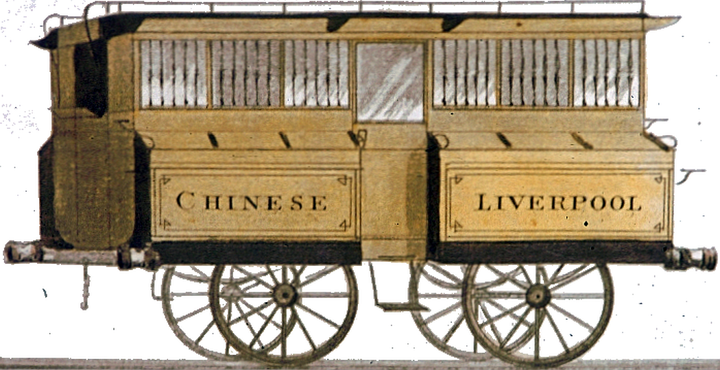
Some time ago I mused on the design of what I called the Chinese carriage, largely because the word "Chinese" was written on the side and it looked marginally pagoda-like end-on.

ccblob0
Thomas Talbot Bury's version

ccblob0a
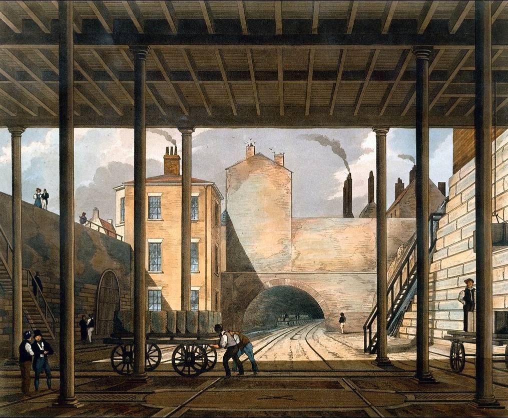
The carriage seen in Isaac Shaw's view of Crown Street, Liverpool

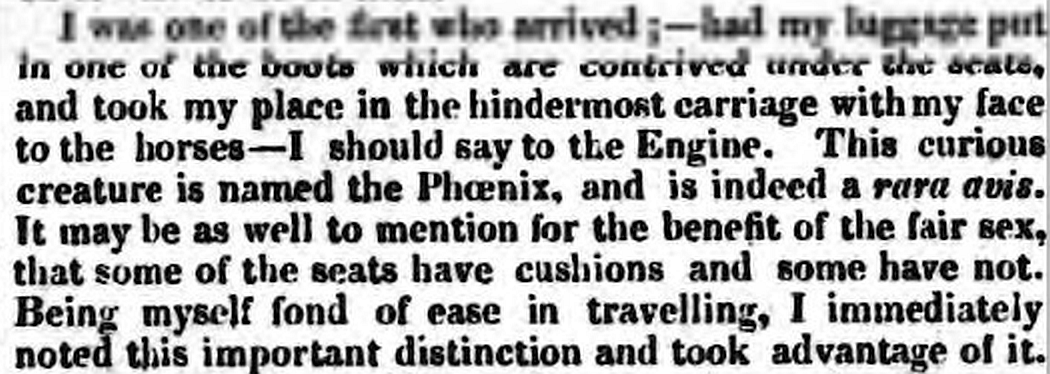
To be fair, I did consider the possibility that the side-bulges were luggage paniers (technically "boots" as per the holds fore and aft on stage-coaches) and so it appears they were, at least according to my reading of a letter published on October 2nd 1830 in the Sheffield Independent. The author was travelling from Liverpool to Manchester but appears to have found his own way to Crown Street station, chosen a comfortable seat facing the engine (presumably not in place at that time) and had his luggage stowed beneath a seat in one of the boots. So far, so unexceptional. Underseat storage was probably the norm.

ccblob1
(c) British Newspaper Archive

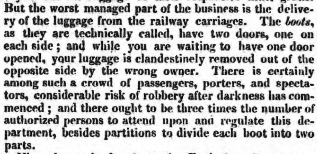
However, on arrival at Manchester, he waited for a porter to recover said luggage only to find that it had already been retrieved from the other side (which I take to mean "outside"). As he was sitting facing the engine, the boot was likely under another passenger's seat. So here we have a luggage compartment with two doors, one inside, the other outside.

ccblob2
(c) British Newspaper Archive

Whether external access is via the (rather narrow) lid or, perhaps more likely, the hinged vertical panel is unclear. In the former case retrieval is also awkward due to the height and the need to deal with what appear to be six boots either side of the carriage. Some haste will be in order if the train is due to make a return trip so it is perhaps unsurprising that the porters empty the boots as quickly as possible without entering the carriage via the proportionately smaller number of doors.

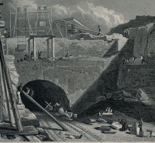
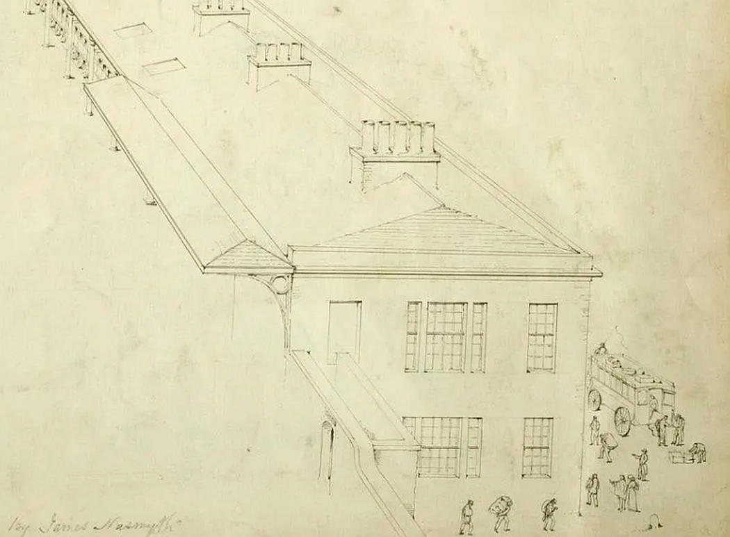
This is especially true for the arrival station at Manchester which was not opposite the departure platform (the 1830 warehouse was in the way) but on the far side of the Water Street bridge. James Nasmyth captured some of the fraught activity associated with an arrival with a host of porters carrying baggage down under the bridge and along to a horse-drawn omnibus parked outside the station entrance on Liverpool Road (Science Museum CC-BY-NC-SA).

ccblob3

The uncertainty was compounded by shared use of the boots without partitions and the presence of cads attempting to hijack passengers to rival hotels. Of course, there was also a facility to place luggage on the roof so the scene must have been one of organised chaos, especially to the uninitiated.
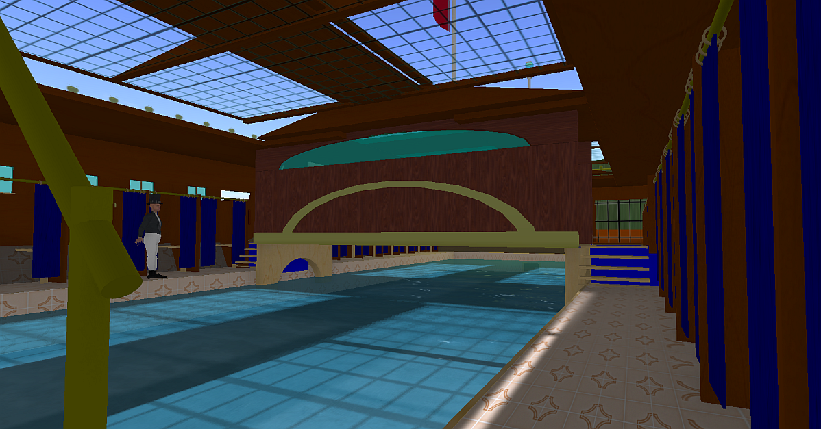
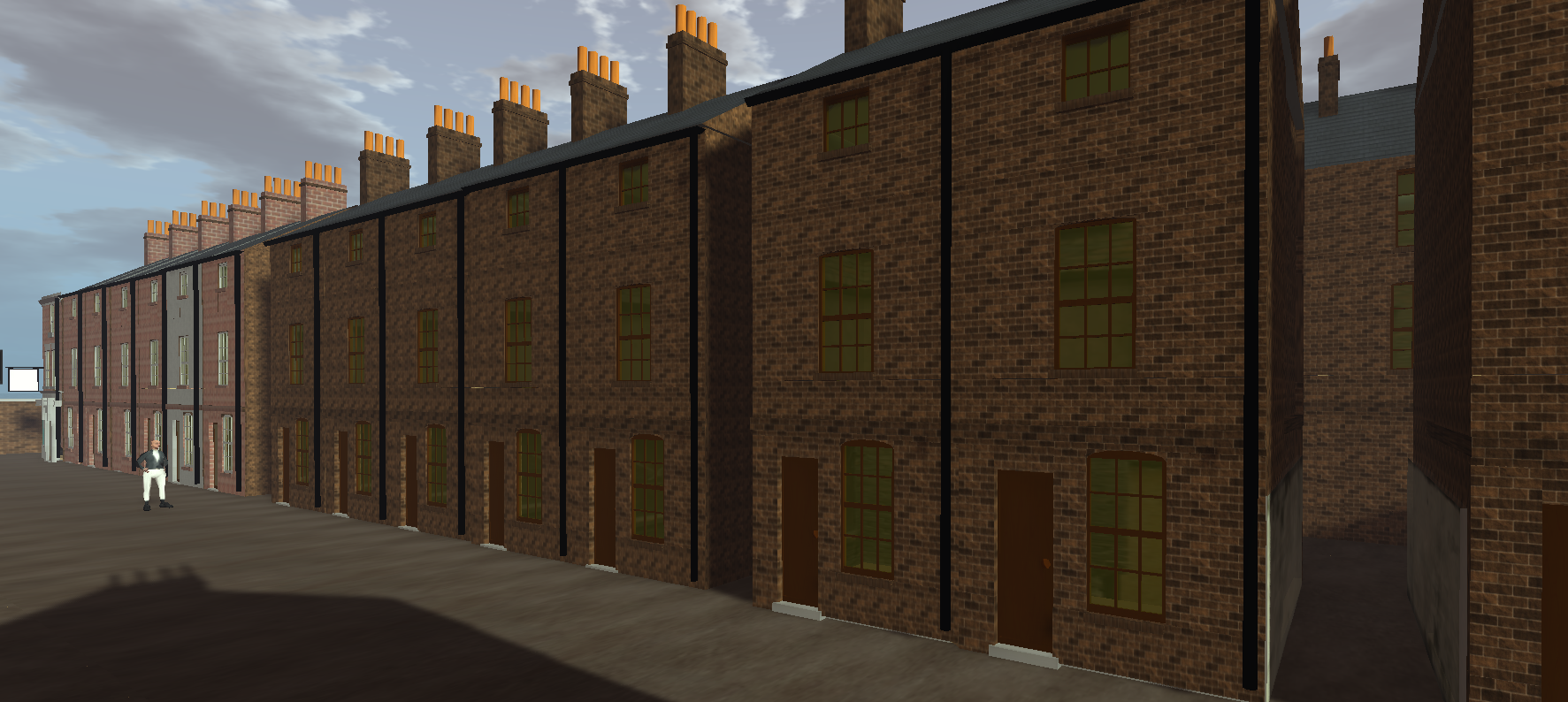
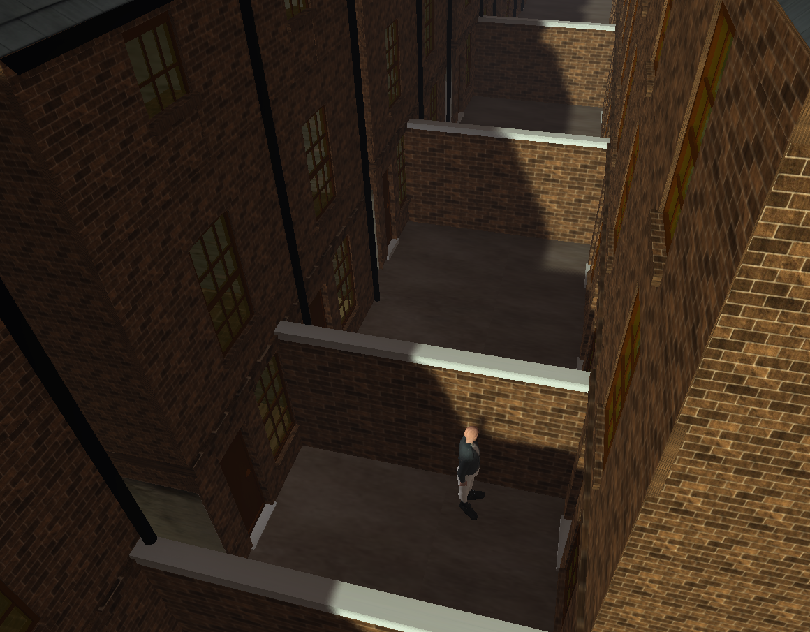
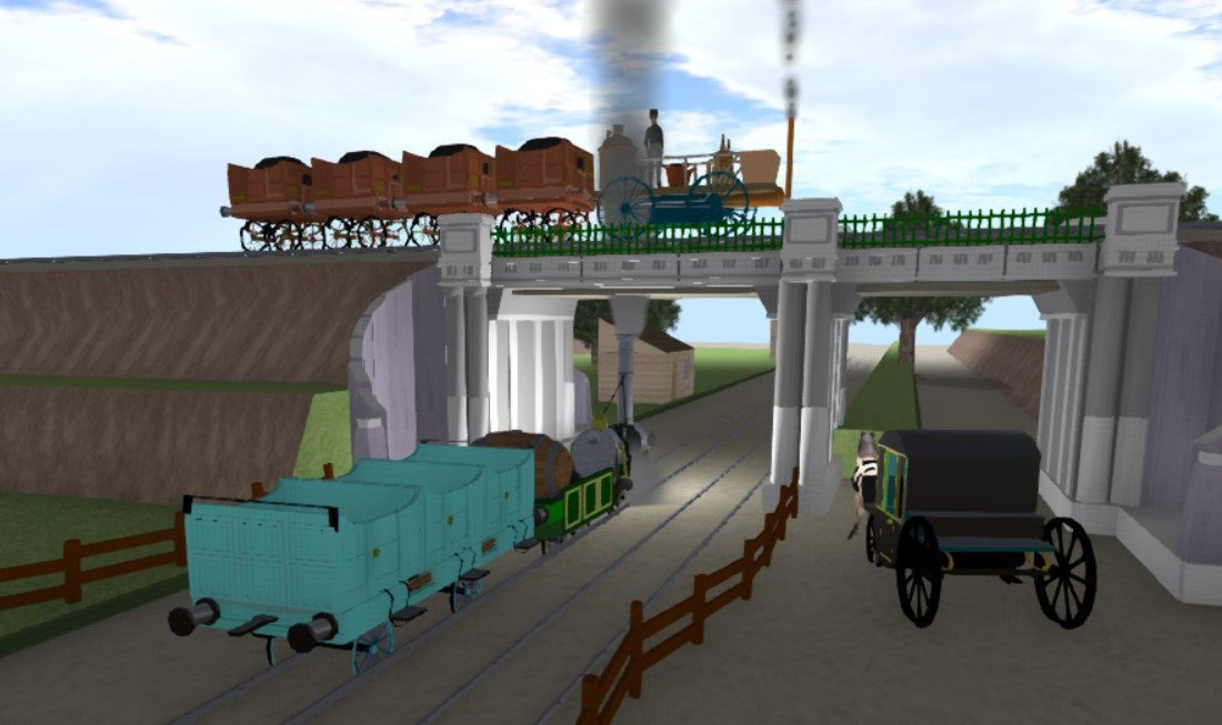
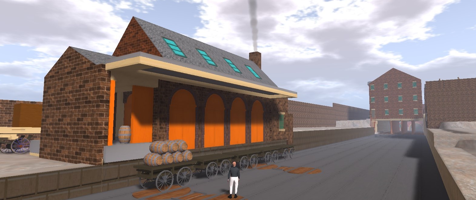
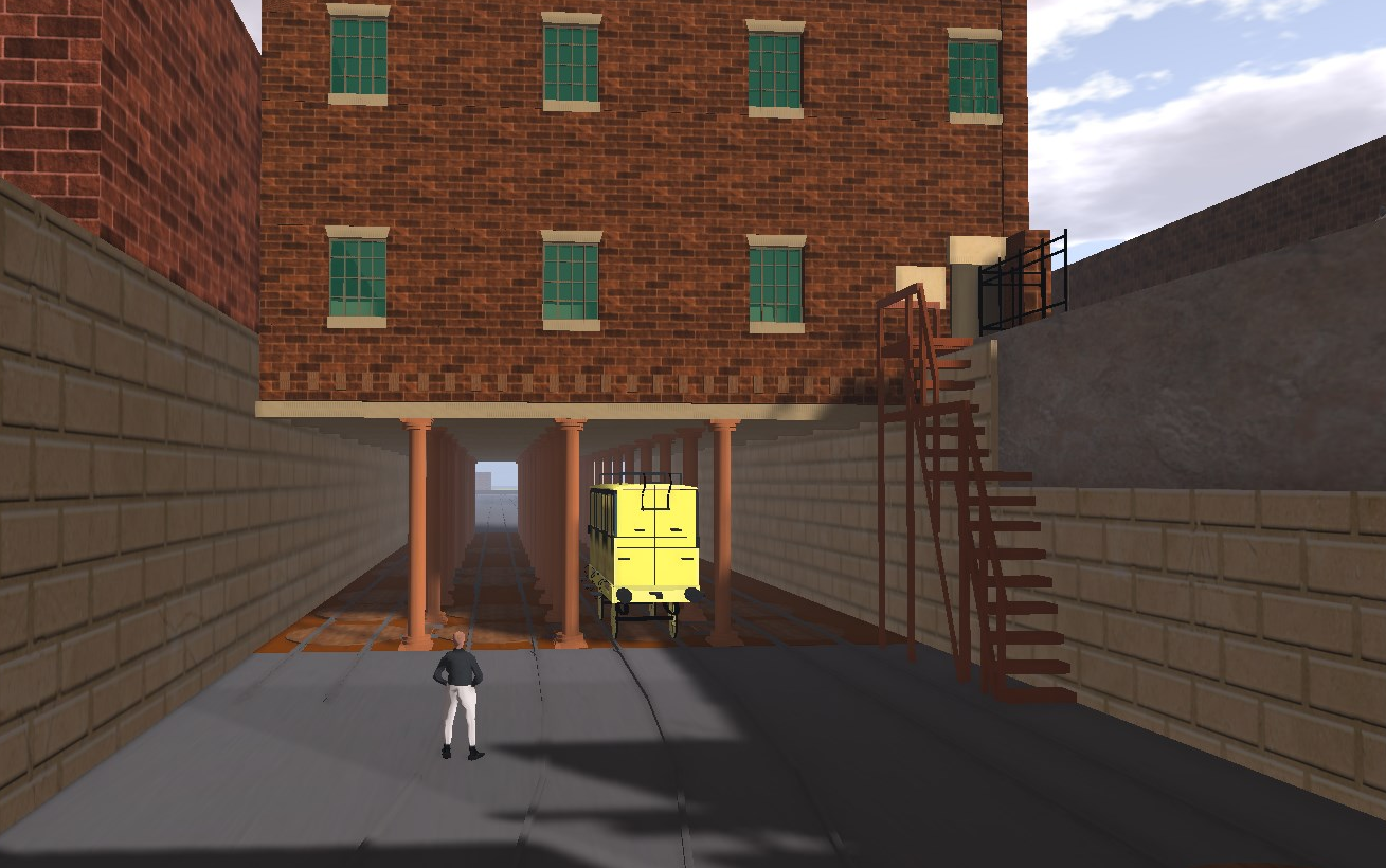
The OpenSim build

A quick build illustrates the possible layout of the Chinese carriage and, more importantly, some of the constraints. Firstly, the underseat storage is limited to seats along the sides of the carriage. The externals struts or edges to the boot lids suggest that these were shared in pairs in order to accommodate five seats per side per half-carriage yet still allow the end one a chance to open against the two (fully cushioned) seats against the end of the carriage.

chinese carriage inside

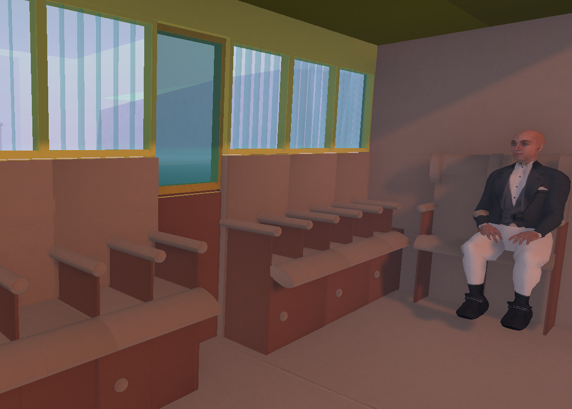
This gives 24 seats per carriage which is the same as three compartments with four per side. It would be a tight fit, especially at the ends with the compensation perhaps of superior leg room compared to standard carriage designs.

ccblob4

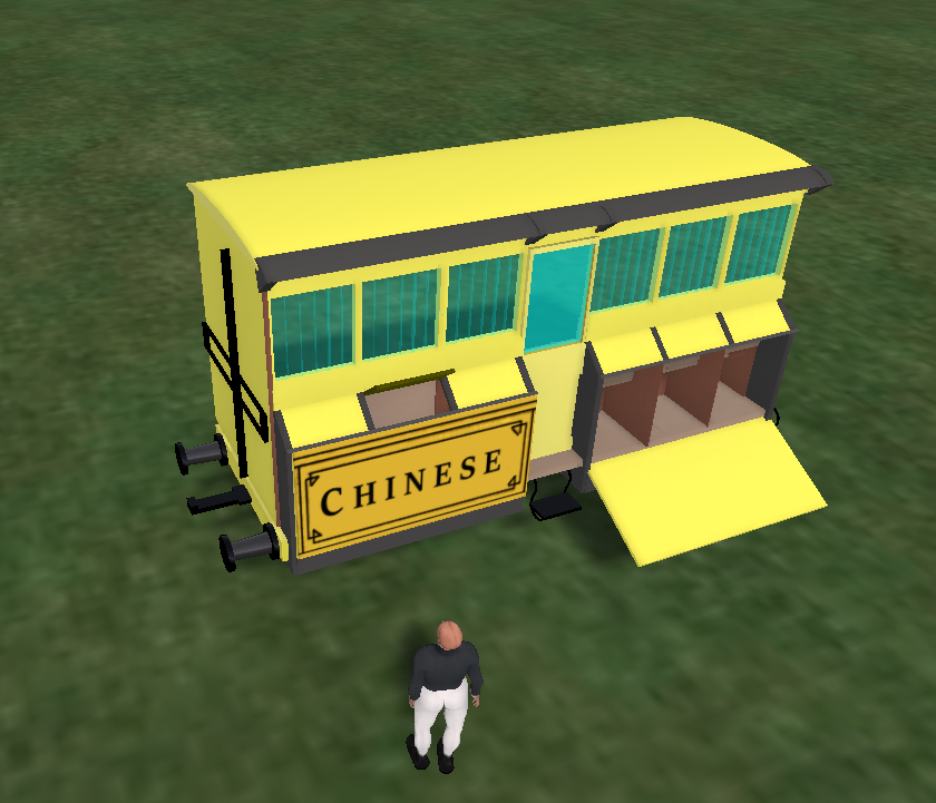
Externally the drop-down side panel looks much the better bet although it might be argued that the roof overhang was, however briefly, to protect the boots when the lids were open. The handles visible in Bury's closeup at either end of the side panel might have been for lowering it as well as providing assistance on mounting.

Coach building

In 1828 Stephenson, acting on James Cropper's recommendation, hired coachmaker Thomas Clarke Worsdell to manage construction of the carriages and pertinent items start to appear in the Finance Committee minutes from 23rd May onwards, e.g. red pine timber, mahogany, beech, wheels, axles, iron plates, brass coach furniture, broad cloth and fringe for coach lining. In January 1829 files were ordered for the coachmakers and in February paint. The choice of yellow was made by Stephenson based on the colours used by the fastest road carriages.

The designs were heavily influenced by road coach designs, for example the multi-compartment diligence. Initially many different designs were adopted and these are described in an article published in the Liverpool Mercury on 11th June 1830. The Chinese coach design is not mentioned; indeed, there is specific mention of the lack of space for luggage.

ccblob2a
(c) British Newspaper Archive

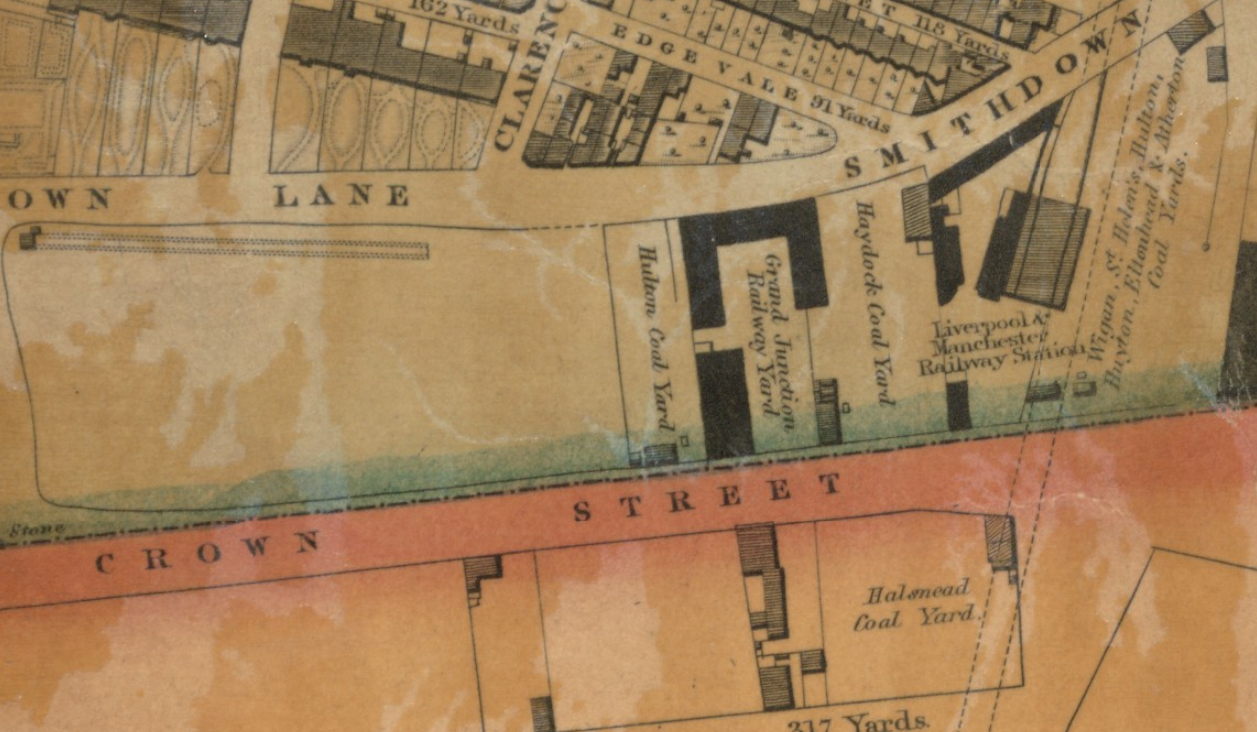
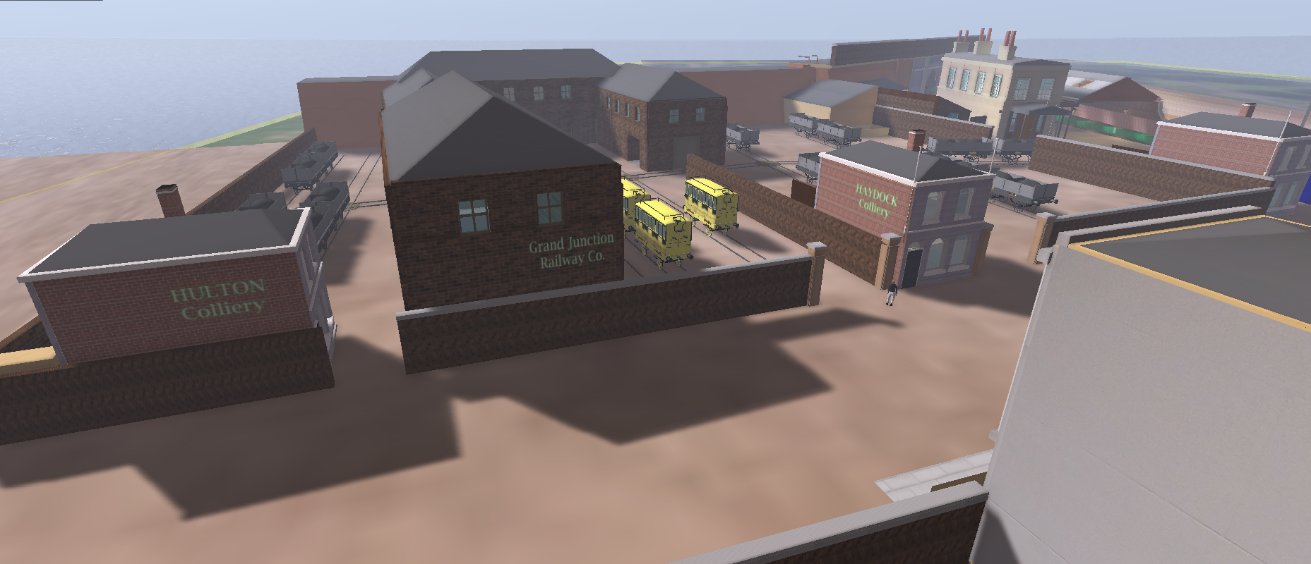
Construction and maintenance took place at Crown Street but transferred to Lime Street when workshops were completed at the new station which opened in 1836.

An inspection run on 14th June 1830 may have seen the first public use of Worsdell's carriages. It employed the locomotive Arrow, two coaches, an open carriage (presumably blue, second class) and seven waggons. It started in Liverpool and went as far as the Oldfield Road bridge, the bridges into the Liverpool Road station still being under construction.

Coach names

Most prints show the carriage name on the centre door. This does not seem to apply to the Chinese carriage which appears in three early prints, two by Bury and one by Shaw, raising the possibility that there was more than one carriage of this design, named or otherwise.

Names from Thomas, p. 253.

Velocipede, Lord Derby, London, Fly, King William, Queen Adelaide, Duke of Wellington, Sir Robert Peel, Earl of Wilton, William Huskisson, Marquis of Stafford, Sovereign, Clarence, The Lark, Greyhound, Traveller, Harlequin, Victory, The Delight, The Times, The Globe, Experience, Treasurer, Despatch, Conservative, Reformer.

Possible names from 1828 minutes of the Finance Committee

These derive from invoices for wheels, axles, etc mentioned in passing.

Cumberland, Nimble, Jean, Jenet, Hope, Bellona, Mercury, Eleanor, Expedition, Anne, Betsey, Jane, Turtle Dove.

Given the absence of overlap, it is possible that these names were used during construction and changed subsequently. Otherwise it suggests that there may have been about 40 glass coaches not including any subsequently built for the mail and, perhaps, the Chinese carriage(s).

Beyond the L&MR

Names do not seem to have persisted beyond the mergers of the mid-1840s. It may be that the railways by that stage were keen to distance themselves from their road forebears rather than mimic them.

Likewise, the L&MR does not seem to have adopted the saloon or external boot layouts to any great degree. Perhaps negative feedback from passengers, the availability of the roof and the requirement for access from trackside were sufficient disincentives.

Renumbering Lawton Street

I've been investigating nineteenth century Lawton Street and the Brougham Institute in particular. The various online street directories can tell us much about the life of a street in terms of who lived there and their occupation. However, insights into a street's appearance require matching street numbers to map location and layout plus such imagery as can be found. Horwood's map of 1803 and Goad's fire insurance maps of 1888 can be useful in places but Horwood's map lacks numbers for Lawton Street and detail on Goad's much later map masks much of the evolutionary development of Lawton Street with the street disrupted by the advent of Central Station.

liverpool bold st ex 1865 pano centred on lawton st
Fig: Lawton Street proceeds up to Renshaw Street to the left of centre on the 1865 panorama by Sulman & Jackson. CC-BY-SA 4.0 Historic Liverpool.

However, Goad's map also obscures the fact that street numbering changed mid-century. Initially it had proceeded up one side and then back down the other before changing to the more familiar odd numbers one side, evens the other. In Liverpool the impetus for renumbering came from the council Health Committee in 1852 and was a response to the rapid and relatively uncontrolled development of Liverpool. Whether it was motivated by the need to unambiguously identify properties in need of cleaning or improvement is unclear.

Renumbering was driven by Health Committee

The first step was for the Borough Engineer to develop and test plans for renumbering. The strategy is a little obscure but seems to have involved numbers of different colours depending on whether the new or old system was being followed (presumably buildings were labelled with both so old and new addresses alike could be used). Old numbers were in black, new ones in red. Letters a to c could also be used, presumably appended to numbers where a new build had been inserted and existing sequence was to be preserved. The Brougham Institute, for example, was numbered 6a.

The next step was to seek funds from the Finance Committee and the Health Committee nominated Councillors Beckwith and Johnson to liaise. There things stalled, however, presumably because Finance Committee demurred. The Town Clerk came to the rescue with advice to the effect that the Finance Committee could be bypassed; if Council gave its approval in addition to the Health Committee then Finance Committee would have to fall into line.

Whether this proved necessary is unclear but numbering was eventually begun, probably in late 1855, and apparently completed in 1856. It was not without consequence. One workman carrying out the numbering was subject to criminal assault and another accused of the same, plus the renumbering caused extra work in terms of election admininstration. Overall the change must have been perceived as positive as Birkenhead then considered a similar updating.

Lawton Street was in the trial

One peculiar facet, however, is that Lawton Street may have been one of the streets included in the Borough Engineer's trial. The numbering in 1829 appears to run from the east side of the junction with Ranelagh Street up to Renshaw Street and then back down the opposite side to the west side of the Ranelagh Street junction, just behind the Waterloo Hotel. The buildings next to the hotel (and behind the Lyceum on Bold Street) were apparently warehouses but include one, possibly more, owned by drysalters Harrop, Hill & Smith who were probably making dye for paints, Smith operating the so-called Waterloo Mill as part of this process. Other likely anchor points include the residence of the Drummond family at number 31 and, between these, a building belonging to the Machell family who owned and operated the ropery from number 34 and may have had a chandlery there.

liverpool lawton st map numberingv2
Fig: Lawton Street on Gage's map of 1836. CC-BY-SA 4.0 Historic Liverpool.

However, Gore's directory of 1853 (three years before the main renumbering) shows a reversal of numbers with the Drummonds (William now rather than John) at number 14, hotelier/publican Mary Williams at 10, provision merchant David Tomb at 8, Newton & Edwards (cement manufacturers) at 6 and auctioneer William Holbrook Jackson at 4.

A later sales advert suggests that Williams created her 13-bed hotel, the Crown, from two existing houses. In fact, Lawton Street had three, possibly four licensed premises, including the Dog, the Lord Hill and a spirit vault called the Cottage (perhaps in one of the original cottages on the street or in one of three behind the Crown). Its proximity to the large works of builders Foster & Stewart likely meant there was no shortage of custom and the size of the Crown made it a popular venue for meetings and function dinners. This was in stark contrast to the temperance ethos of the Brougham Institute at 6a which rather pointedly held an annual anniversary tea party and ball.

This numbering is consistent with Goad's 1888 fire insurance map which shows even numbers ascending towards Renshaw Street on the south side of what little remains of Lawton Street after the advent of the high-level Central Station in 1874 (work probably started in 1864).

All this is very tentative at the moment as regards Lawton Street and more research is required. However, knowledge that street numbering changed in general in 1855/6, and for some streets a few years earlier, may be useful to others.

Coglan's Floating Bath

Tourist guides to Liverpool were extolling the virtues of bathing in the Mersey estuary as early as 1803. There were seaside hotels up at Bootle and bathing machines and private baths established nearer the growing town around 1765. In 1794 the corporation acquired the latter which had separate facilities for males and females with 30 x 33 ft baths and the option of sea swimming when the state of the tide allowed. However, as the docks extended northwards so the baths became separated from the estuary and they ultimately closed in 1817.

liverpool herdman old baths
Fig: The old baths off Bath Street.

While the corporation pondered its next steps, private enterprise stepped forward in 1816 in the guise of Unitarian Liberal Thomas Coglan. Coglan's approach was radically different in establishing a floating bath in a ship moored some distance offshore. Floating baths were nothing new; continental examples dated back to the 1760s and London had one on the Thames established by a Mr Fox in 1810. However, mostly these were moored at the riverside unlike Coglan's which was variously 200-400 yards from the docks.

liverpool floating bath 3
Fig: Mr Coglan's Floating Bath

The reason for this seems to have been the common practice for males to bathe naked and the perceived need to remove such outrageous behaviour from public view. Although most sessions were male-only, the Liverpool floating bath later instituted 1-2 female-only sessions per week (females sometimes also bathed nude as became apparent in 1880 when the floating bath at Bridgnorth sank during one such session, leaving the doubtless distressed participants to swim to the bank minus their clothes).

Who was Thomas Coglan?

Coglan (??-29/06/1841) was a Dublin-born auctioneer and stocks and shares broker. Family records suggest that by 1818 he was living with his wife Martha on Denison Street. This was close to the north shore and it is possible that Coglan was an enthusiastic swimmer as well as having sufficient means to fund a venture potentially at odds with the corporation's own plans.

He was an early trader in railway shares, a founder member of the Liverpool Stock Exchange and stood successfully in the St Anne's ward as a Reformer for election to the council in 1835 and 1838. On his demise his wife Martha held a substantial investment in the Bank of Liverpool.

As the docks expanded northwards Coglan moved to more affluent Bold Street where he appears to have lived over a business offering warm and vapour baths, perhaps run by Martha given his other interests. According to Horwood's 1803 map, 19 Bold Street was likely on the east side between Newington and Heathfield Street, perhaps the extant three-storey terraced building with quoins and eared architraves around the windows.

bold st 19
Fig: Possible 19 Bold Street according to old street numbering scheme (ex Google Maps)

In the 1830s Coglan moved to Stafford Street, now in the so-called Fabric District.

Coglan's commercial offices were initially at 3, Statham's Buildings, 84 Lord St, although he later moved to 19/21 Exchange Street East. Statham's Buildings were probably affected by the widening of Lord Street in 1828/9 following the Act of 1825.

Construction, launch and early operation

Coglan's Floating Bath was constructed in Hamer's yard and launched on 11th June 1816 to great acclaim, providing a welcome diversion from the election then underway. The £3000 expense of fitting-out a purpose-built ship was supported by a scheme that guaranteed four years of free swimming for £20. Many doubtless also saw it as a public "good" in terms of encouraging healthy exercise and a useful skill while at the same time mitigating the problems off the north shore.

While tourist guides advanced the tonic properties of immersion in cold water, Liverpool doctor James Currie was one of several who identified possible medicinal properties, including in his case treatment for typhus. Nevertheless, the floating bath was a summer-only operation, retiring to the then undeveloped Wallasey pool over the winter.

The ship had buoyancy tanks that allowed it to carry estuarine water that entered and departed via grated sluices at either end. According to Samuel Holme it was initially moored some 400 yards off Pier Head, i.e. Georges Dock, which would place it not far off midstream, handily avoiding whatever effluent emanated from the town and docks. This exposed location may go some way to explaining its sturdy ship-like design. By 1838 the ship was moored 200 yards off Prince's Dock where the middle of the three flights of steps was used by prospective clients.

The facility was open from 06:00 to dusk for a fee of 6d for children and 8d for adults with season tickets also available. The ship appears to have had a rudder or tiller, suggesting that it may have reoriented during the course of the day to face the oncoming tide.

According to one source, the vessel was 82x34 ft with the bath 80x27 ft (and hence larger than the new corporation baths on George's Dock that opened in 1828) with a floor sloping from 3.5 to 6 ft in depth of water. There were numerous dressing-rooms around the pool and some were screened to permit bathers to descend into the water unseen. There was also a small private bath and additionally two cabin areas aft and midships where food, drink and newspapers were available. Strong swimmers could also emerge from the far side of the ship and swim in the estuary itself.

After their swim bathers could go on deck and either promenade or use the tables and seating provided.

Social function

In his autobiography Holme pays tribute to the floating bath for improving his swimming skills and as a young man reckoned on spending an hour there at high tide 2-3 times a week during the summer months. He recalls taking "headers", ie diving, into the water, either from a board 7 ft above the waterline (presumably at the doorway or on the foredeck) or from the promenade deck some 15 feet above.

Clearly the bath was also a place to mix socially and Holme notes that Egerton Smith, founder/publisher of the Liverpool Mercury, was one of the best swimmers. It is perhaps unsurprising then that another of Smith's publications, The Kaeidoscope, published an anonymous letter from son to father begging for a season ticket as well as a piece by Coglan on the benefits of vapour baths.

While Holme went onto a successful career as a builder (St George's Hall was one of his) and Tory Mayor of Liverpool, more radical elements also met at the bath. Thus on a visit London publisher Richard Carlile used the excuse of a swim to encounter Egerton Smith and his Mercury colleague John Smith who, like Carlile, had been at Peterloo in 1819. The Smiths may have used the informal atmosphere of the floating bath as a general means of gauging public interest and sentiment.

On at least one occasion the ship was used as the base for swimming races in the river albeit with limited success as the strength of the current forced many to retire. Nevertheless, it attracted thousands of spectators on the dockside.

The new baths

baths ex lancs illust
Fig: The new baths designed by corporation architect John Foster Jnr.

In 1828/9 the corporation finally built new bathing facilities on the west side of George's Dock and concern was expressed that this would damage Coglan's trade and investment. However, it is clear from his dealings in a number of railway shares that he remained solvent and his death in 1841 preceded the crash in railway shares in the middle of that decade.

Tourist guides show that the bath continued to operate until at least 1843 although it increasingly became an impediment to shipping.

The OpenSim model

A tentative OpenSim model has been constructed. There is apparently a Herdman illustration of the interior but this could not be found online so a design has been adopted based on the above description.

coglan1r
Fig: Exterior view

The standard representation of the ship shows a hull with a row of portholes and a door roughly midships. The deck above has railings but little obvious superstructure beyond a flagpole. It seems likely therefore that the door gave access to the central cabin which presumably bridged the actual pool as well as providing access to the poolside.

The portholes presumably open above the changing cubicles and thus provide light to both cubicle and pool. Given that operation ceased at dusk, it seems not unlikely that the deck incorporated one or more skylights.

coglan2r
Fig: Interior view

The published measurements allow for a poolside margin but no space for cubicles. Accordingly a metre is added at either side for changing space. It is assumed that these were dedicated to individual customers so no separate storage area for baskets is assigned. If that was the case, it caps the number of swimmers at around 32 although there are reports of as many as 500 using the baths in a day.

The aft area also had a cabin space and it is possible that the small private bath was also located here. his area has some superstructure. While this may in part be related to the tiller, it is also possible that a kitchen was located here and two small chimneys protrude on the superstructure. It may also have housed the staircase to the promenade deck.

Nothing is known of the staffing arrangements on the ship although with at least two rowing boats and presumably some management and galley provision, it seems likely that 4-6 people were temporarily employed. There is no evidence of swimming tuition or supervision though the pool boasted not a single casualty in the 27 years of its operation.

See also a more general review of Liverpool as a coastal resort.

Mulligan and early court housing on Peter Street

The first recorded Liverpool address for Irish potter/poet Hugh Mulligan is on New Peters Street (later Peter Street) off Whitechapel where he lived between 1770 and 1774 (dates non-exclusive). Mulligan was an early mentor to William Roscoe and a member of a small set with anti-slavery views considered radical in a port based largely on the "African" trade.

Both terraced ends of the east side of Peter Street appear in Herdman paintings, the Whitechapel end merging into a row of shops and the other end capped by a pub and in the process of being demolished by Herdman's time.

The middle of the street, however, is not shown and I suspect that this area was occupied by an early form of court housing. As ever, a work in progress, much conjecture.

liverpool williamson 1766 map ex harvard peter st
Fig: Williamson's 1766 map shows only the Frog Lane (Whitechapel) end of New Peter Street built out. North is to the left.

Peter Street

The origin of the name Peter Street is unclear. Nearby Stanley Street was named for the local Stanley family who owned the land and it is possible that the Peters family were likewise responsible for Peter(s) Street. The Peters family were wealthy merchants and Ralph Peters, who lived on John Street, became Town Clerk.

The first intimation of Peter Street appears on the 1766 map by Williamson on which it is laid out but only part-built. By 1769, however, both sides of Peter Street were built out and Horwood's map of 1803 shows in excess of 100 dwellings on or adjacent to Peter Street. It seems likely therefore that the house that Mulligan moved into was only a few years old.

liverpool whitechapel herdman r
Fig: Peter Street (left) as seen from corner of Dawson Street with the main thoroughfare of Whitechapel running left to right. Painted by WG Herdman in 1858. British Museum CC BY-NC-SA 4.0.

The street was demolished in the 1860s and the only visual record I have been able to locate comprises two watercolours by Herdman. In 1858 he painted a view of Whitechapel that included part of the south side of Peter Street and in 1867 a view of the opposite end of the street where it turned into Shaws Hill Street. The buildings are shown in the course of demolition although the corner pub is still occupied judging by the washing hanging across the street.

Both ends of the street show three-storey, single bay terraced housing with a narrow frontage although in at least one case there is a suggestion that two adjacent dwellings have been merged. There are also decorative additions to doors and at least one extra window.

The house seen in the course of demolition appears to extend back the full extent of the building. The visible doorway may be to the stairs and it is plausible that a wall once extended in line with it to form two rooms, front and back; if so, access to the back room would appear to be via the front. The stairway hints at the tight spiral staircase common at the time and observed at 10 Hockenhall Alley where it is at the right rear of a building with perhaps half the depth seen here.

liverpool cross hall st herdman 1867 c
Fig: Derelict court housing on Cross(e) Hall (Crosshall) Street. The front house was likely a back-to-back that has been extended while the back house abutted the back houses on the south side of Peter Street although it was built later. The Municipal Buildings on Dale Street can be seen in the background.

Some idea of the back houses on Peter Street may be obtained from a painting by Herdman of a partially demolished Crosse Hall (Crosshall) Street. This shows a full-size front house possibly extended at the rear and behind it a back house which is roughly half the depth of the standard front house. The back house may have been built after those on Peter Street (sometime between 1803 and 1835) and accordingly created a faux back-to-back not necessarily aligning with those to the rear off Peter Street.

Perry's 1769 street plan supports this view as it shows on the south side so-called back houses accessed via narrow alleys between front houses. Horwood's map suggests that the mid-street front houses were themselves small-footprint back-to-backs clustered in fours, two on the street, two facing the courtyard. Their appearance may have resembled the extant but now dilapidated house on Hockenhall Alley, three storeys with a single bay (Herdman view, internal photo, external photo, 1930s.

liverpool 10 hockenhall alley by phil nash ex he site
Fig: Grade II-listed No.10 Hockenhall Alley. Photo by Phil Nash from Historic England website.

Life in early court housing

While later courts had shared provision in terms of privies, ash cans and clothes washing, early courts may have replicated the general C18 century experience.

Water may have been obtained from a water carrier or from the Fall Well which was only finally closed in 1790. Clothes were traditionally washed and dried in the area now occupied by St John's Gardens, adjacent to the well.

Mains sewerage was almost certainly absent with nightsoil being collected, possibly from an earth midden though none is evident on the exterior.

Streets and courts in the OpenSim model have been left unpaved/flagged. Although Herdman shows Castle Street with pavements in 1786, it is not clear when side streets were addressed although they are shown in his later pictures of Peter Street.

OpenSim build

liverpool peter st far end 1
Fig: Peter Street. A pub can be seen at the far end on the corner of Shaw's Hill Street. To the right is a narrow access to one of the courts via the limewashed alleyway.

liverpool peter st opensim 2 courts
Fig: The first court off Peter Street appears to have had only two dwellings facing one another.

Perry's map shows walls delineating four courts containing a total of six back houses. These may have varied in size with some larger than the basic unit (slightly larger than 3x3 m) located at the rear of the first court (as seen from Whitechapel).

This raises an interesting possibility, namely that the back houses may have been of interest to those running micro-businesses from home. The court may have provided some storage or work space and larger houses would have additional rooms for small-scale enterprise, albeit cramped. Stewart observes that work carried out in the court by the likes of oakum pickers often contributed to their run-down state. Taylor similarly suggests that cellars may have been sub-let not only as living space but for "people following trades."

By contrast the other side of Peter Street was more conventionally built with few back-to-backs and back houses. Court construction was a largely speculative enterprise and it may be that the landowner decided on a limited trial in the first instance until a viable market was demonstrated. Stewart cites returns of the order of 10% per annum.

With the downturn in the pottery business Mulligan may have become self-employed with a room in one of the larger back houses which he dedicated to pottery decoration and copperplate engraving. That said, there are other outhouses on Perry's map that might have been a smallscale business workshop or, of course, Mulligan may have worked elsewhere as he did at the pottery on Brownlow Hill and perhaps subsequently when it moved to Park Lane.

Later developments

Later courts would typically have 3-4 houses on either side of the yard space with a water pump and shared provision in terms of privies, ash cans and washing. None of this is apparent on Perry's map although this could simply be a matter of resolution. They are visible to a degree on Gage's map of 1835.

liverpool gages map peter st x2
Fig: By 1835 there are small buildings in the courts that probably represent privies etc. There are also additional courts, house extensions and other developments to the rear. The alleys leading to the courts may have been built over to give the tunnel entrance characteristic of many courts.

Residents and reputation

Those living on Peter Street in the 1770s appear to have had diverse occupations drawn from groups including mariners, artisans and labourers but not, for example, merchants. This was low-cost housing for those required to live close to their work in the centre of town. Among the artisans was at least one further potter (Scarisbrick) as well as one or more of weavers, joiners, bricklayers, ropemakers, shoemakers/cordwainers, sail makers, shipwrights and watchmakers. There was at least one shopkeeper, a tobacconist, but his shop or kiosk may have been elsewhere.

Over time, however, the street (and others nearby) gained a poor reputation, Hume's map of 1858 identifying it as an area of "crime and immorality". Densely populated with lodging houses as well as courts, it featured periodically in lurid news stories involving murder, violence against children and dog-fighting.

Whether this trend started much earlier and contributed to Mulligan's decision to cross Whitechapel and live in nearby Charles Street is unknown. As Elizabeth Stewart notes in her recent book Courts & Alleys, it is unwise to generalise on the condition of court properties or the experiences of their occupants.

Around this time Mulligan dropped the designation "potter" from his entry in Gore's directory so another possibility is that his aspirations in that direction had run their course and Charles Street seemed a better fit for the future.

Demolition

As well as perhaps being an early example of court housing, Peter Street was also among the first to be demolished despite the apparent absence of the infamous cellar dwellings (Taylor seems to suggest that there were some in the vicinity but not a uniform distribution). This presumably came about as a result of bye-laws in Liverpool's Sanitary Amendment Act of 1864 which, in the face of recurring cholera outbreaks, introduced new building regulations and powers of compulsory purchase for demolition of slum properties.

In 1867 the Medical Officer of Health, Dr William Trench, recommended demolition of 387 houses to counter the threat of typhus and cholera. This correlates with the date of Herdman's watercolour. While the cholera map of 1866 suggests that there were fatalities on Peter Street, the number was not on a par with other areas of the town.

It is of possible interest that Herdman seems to have only recorded the area from within as it underwent demolition. Perhaps Peter Street was a place he preferred not to linger in when populated but a place he felt deserved to be recorded for posterity even as a shadow of its former self.

Much of the site is now occupied by the 1872 Midland Railway Goods Office by Sumners & Culshaw latterly converted into a Conservation Centre. The destruction of inner city housing in favour of railway developments was a commonplace event in Victorian Britain. What happened to the displaced residents is largely unrecorded.

liverpool midland railway goods office
Fig: The former Midland Railway Goods Office. Peter Street is to its left, Crosshall Street to its right.

Further info

Stewart. Courts and Alleys
Taylor. The Court and Cellar Dwelling: the Eighteenth Century Origin of the Liverpool Slum

Roscoe and Mulligan

Liverpool's cultural development during the latter part of the eighteenth century was greatly influenced by William Roscoe. Roscoe, however, was famously of relatively humble origins, his father at the time of Roscoe's birth being an innkeeper. Leaving school at 12 to work in his father's market garden, Roscoe would later acknowledge the role played by an early mentor, Hugh Mulligan, in introducing him to the arts. Indeed, Mulligan is credited as an influence in the biography of Roscoe written shortly after his death by his son Henry.

Very much a work in progress…

Mulligan is often mentioned in passing as a somewhat enigmatic Irish poet who was by trade a painter of pottery and a copperplate engraver. He was employed by the china works on Brownlow Hill owned by James Pennington. The works backed onto a bowling-green behind the inn on Mount Pleasant run by Roscoe's father, the New Bowling-Green Inn.

liverpool mount pleasant map 1790
Fig: Although the area was a little more developed by the time of this map (Gore's, 1790), the two bowling-greens on Mount Pleasant and associated inns are still evident as are the market gardens at the bottom of the hill. The U-shaped Brownlow Hill china works can be seen behind the lower bowling-green along with the windmill used for grinding colours although by this time the works had closed.

Pennington moved the business to Park Lane in 1767/8. Whether Mulligan moved with it is unclear. The manufacture of ceramics for the most part declined in Liverpool (the Herculaneum Pottery was for a time the exception) although the decoration of pottery manufactured elsewhere continued. During his formative years, however, Roscoe in his spare time could go to the nearby china works and there he acquired the basics of painting from Mulligan.

The Irish poet (nicknamed Mully or Little Mully, presumably a reference to his stature) may also be the subject of a verse in Roscoe's poem Mount Pleasant written at this time. If so, it suggests that Mulligan was an excellent performer of his poetry and perhaps more generally a popular raconteur. Roscoe wrote the poem when he was 16 although it was published much later in 1777. It is notable for verses directed against the slave trade and the greed it engendered. These were radical and potentially dangerous ideas to hold in Liverpool at this time, thoughts that Roscoe and Mulligan likely shared with a select circle.

mully1
Fig: Verse from Roscoe's poem Mount Pleasant possibly referring to "Mully" alias Mulligan.

Giving up working his father's market garden, Roscoe now briefly tried his hand at bookselling before becoming apprenticed to an attorney. When he qualified in 1770, his spare time was used to further the arts in Liverpool, a town very much focused on commerce and in particular the slave (or "African") trade.

liverpool roscoe houses
Fig: Convention has it that here were two Bowling Green Inns owned by Roscoe's father on Mount Pleasant. This image from Herdman's Pictorial Relics has them mis-labelled from this conventional standpoint although Herdman claims in a footnote that his interpretation is correct. Convention conversely has it that Roscoe was born in the one on the right in 1753 but his family moved to the one on the left a year later.

By now a relatively wealthy attorney, Roscoe played a leading role in organising the Society for Artists in Liverpool (pdf). Although short-lived, the society organised the first provincial art exhibition in the country. It was held in in 1784 in Roscoe's new house on Rodney Street (one of the earliest in that road and still extant). While Roscoe contributed two sketches, his early tutor Mulligan is notable by his absence.

liverpool rodney st roscoe by mayer
Fig: Roscoe's house, setting for the first exhibition (from the article by Mayer).

The early radical circle encompassing Roscoe and Mulligan may also have included the Irish-born clergyman and author George Gregory who lived briefly in Liverpool and later wrote to his friend Roscoe on 12th Feb 1801 asking that a guinea be given on his behalf to "poor Mulligan."

Where Roscoe had prospered, Mulligan had not.

Mulligan's travails

Mulligan appears to have had at least six children and the dates of their premature deaths allow Mulligan's location to be approximated via parish records. Thus he lived on (New) Peter(s) Street between 1770-1774 and then at 3 Charles Street 1778-1785 (dates non-exclusive). The children (Ann, Thomas, George, James, Sarah, Elizabeth) were buried by their father in the graveyard at nearby St John's (formerly behind St George's Hall). The identity of their mother, however, is unclear.

A somewhat cryptic inscription on the Mulligan portrait (see below) alludes to one Sarah Granger as being "dulcinea to his Fable Knight of La Mancha". However, the idealised Dulcinea described by Cervantes was the object of Don Quixote's unrequited love and her reality in any case far removed from his vision.

A woman called Sarah Wright was married to labourer James Granger at St John's church in 1790 although there is no necessary connection to Mulligan.

An outside possibility is that the famously benevolent Mulligan was somehow acting in loco parentis for children of women who for one reason or another could not bury them. The mortality rate for infants was notoriously high in some areas of Liverpool.

liverpool whitechapel 1790
Fig: Map of central Liverpool published by Gore 1790 showing Peter and Charles Street either side of the diagonal street labelled White(chapel) with St John's at the top.

From around 1780 onwards the blind poet Edward Rushton began composing radical verse and around 1792 opened a bookshop on nearby Paradise Street. He would become an important member of Roscoe's circle.

Around this time Mulligan was similarly a bookseller on Whitechapel and in 1788-1789 he co-published a newspaper with Rushton, the Liverpool & Lancashire Weekly Herald. Mulligan appears to have closed the paper in response to a visit by naval officers following a piece by Rushton critical of the activities of the press gang.

Nevertheless the two remained friends and Rushton would later compose an elegy to Mulligan and his 1806 ode To a Bald-headed Poetical Friend may be similarly directed. Mulligan likewise used Rushton as the lightly anonymised subject of one of his poems "Epistle to Mr. E___ R___".

Mulligan published a book of anti-slavery poems in 1788 possibly following Roscoe's lead. It received mixed reviews but remains of academic interest. Around this time Mulligan is listed as a copperplate engraver at 3 Charles Street in 1790 Gore's directory to which is added bookselling in 1796 and 1800.

The later elegies by Roscoe and Rushton among others are testament to Mulligan's enduring popularity despite what had become parlous financial circumstances and possibly failing mental and physical health. In 1794 he may have acted as witness at the marriage of Samuel Moore, a painter, and Mary Page.

Final days

For whatever reason Mulligan in his latter days appears to have been taken under Roscoe's wing. Presumably he had no other family to care for him and was almost, if not completely, destitute.

In 1798 a letter from Roscoe to his wife mis-dated 31st April mentions that "little Mully" was found walking in the gardens at Allerton (just prior to Roscoe's removal there from Birchfield). Mulligan was well pleased with the situation and, rubbing his hands, said "Well, well, this will be the place for quietness."

Roscoe's concern regarding Mulligan was shared by his son William Stanley who on 17th March 1798 wrote to his father that "poor Mulligan is very ill."

In 1801 William Stanley writes from Oxford enquiring of his mother whether Mulligan has yet been translated to the Dingles (sic), then a beauty spot on the Mersey where the Roscoes had a house. In the absence of a reply the question is repeated on 17th Jan 1802. Mulligan died on 9th December 1802.

Frog Lane in Mulligan's day

Mulligan lived on New Peter Street (as shown in the 1769 Perry map, presumably to distinguish it from Old Peter Street which became Peter and then School Lane) which at the time ran off Frog Lane (later Whitechapel) halfway towards Dale Street before forking hard right into Shaw's Hill Street. Although there are houses running the length of the street, Perry's map suggests that there were narrow alleyways leading to a second row of interstitial houses, possibly an early version of court housing or alternatively workshops. Although Peter Street these days is dominated by the rear of the former Midland Railways Goods Office, it may have been largely residential in 1769.

Both Peter and Charles Streets opened onto Whitechapel, formerly Frog Lane. This represented the upper reaches of the creek that represented the outfall of the stream from Mosslake Fields and which ended in the pool. The area seems to have been prone to flooding and conditions in cellar dwellings in particular must have been dire. Herdman produced a small sketch of shops in Whitechapel during a flood.

Peter Street had terraced housing at either end and Herdman painted one during demolition c.1860, showing that there was a public house on the corner with Shaw Hill Street (blocked off by this time).

Herdman twice painted the shops adjacent to Peter Street as seen from the opposite corner of Dawson Street and one shows the terrace at the Whitechapel end of Peter Street. The shop at the end of the street has a characteristic chamfered corner, possibly a later modification, that can be seen in a more distant view reproduced in Kay Parrot's book of Herdman paintings.

Somewhat earlier, around 1830, Brierley sketched a row of shops opposite Dawson Street, presumably on the other side of Peter Street.

In 1769 at the time of the Perry map there were still a few open fields off Whitechapel. However, there were also signs of industry. There was a (probably rather noxious) tanyard close to the (Old) Haymarket and a silk house off Preston Street. Sir Thomas Buildings (now Sir Thomas Street) had a coalyard, foundry and distillery.

liverpool herdman whitechapel 1
Fig: Shops on Whitechapel with the mainly residential Peter Street branching off on the left. Image courtesy of British Museum licensed CC BY-NC-SA 4.0.

Perspective

Both Roscoe and Rushton suffered hard times, Rushton losing his sight early in life on a slaving voyage and Roscoe latterly becoming a bankrupt. Each, however, had periods of success and posterity has been kinder to them than poor Mully who, personal and business vicissitudes notwithstanding, remained true to himself and perhaps paid the price accordingly.

We learn more of this radical yet benevolent man from Rushton's elegy. Mayer also quotes an elegy written by a mutual friend, possibly Liverpool printer John McCreery.

The Roscoes were given a posthumous portrait of Mulligan by the artist, Julius Caesar Ibettson, described as "disguised" but "like". The unusual headgear probably derives from a voyage the two made from Hull to Leith to meet Thomas Vernon, a bookseller who went bankrupt in the late 1780s but later became Liverpool's first auctioneer. Ibettson describes Mulligan as a "fellow sufferer" on Vernon's "Scotch campaign" and suggests that they had ended up as a fairly desperate street theatre act with Vernon as showman, Ibbetson a dancing bear and his son and Mully monkeys.

The long clay pipe shown in the portrait, however, was a favourite pastime of Mulligan's. Whether a plantation crop was ultimately a comfort to or the death of Mully remains a mystery.

Acknowledgements: Part of the narrative derives from summaries of letters written by or to William Roscoe and available from Liverpool City Archives.

The Intersection Bridge

The Intersection Bridge was the first bridge to carry one railway, the St Helens & Runcorn Gap (SH&RGR), over another, the better known Liverpool & Manchester (L&MR). It was situated on the Sutton inclined plane not far from St Helens Junction. Although the bridge persisted for a good many years after the line closed, it was much modified and what we know of it derives mostly from an aquatint prepared by SG Hughes and published in 1832.

view_of_the_intersection_bridge,_from_bury's_liverpool_and_manchester_railway,_1832_-_edgehill_2
Fig: View of the iron Intersection Bridge looking east down the Sutton inclined plane towards St Helens Junction and Manchester beyond. The print is dedicated to brewer Edward Greenall, father of Peter who was also a supporter of the SH&RGR.

What the picture tells us

The image (zoomable versions) is interesting for a number of reasons. Firstly, the artist is unknown but is presumably Thomas Talbot Bury who produced a popular series of coloured views of the L&MR published by Rudolph Ackermann. Why he is unattributed here is unclear. He did, however, produce a revised series of L&MR prints in 1833 so likely was available for this commission. However, it is worth noting that the SH&RGR did not open until February 1833 so whether the embankment and bridge were complete and coal being hauled routinely may be doubtful. However, one coal train apparently did run in November 1832 to win a wager that the line would be operable before the year's end; perhaps that event is recorded here although the lush foliage suggests otherwise. The line was supposed to take coal from the collieries around St Helens to the Mersey around Runcorn Gap, modern-day Widnes but the dock was not finished by the time the railway opened in February 1833 and only completed some six months later.

It follows that the interpretation given below is even more conjectural than usual. It may represent circumstances that pertained for a short time or not at all.

The bridge was designed by Charles Blacker Vignoles who produced the survey for the Rennies that underpinned the enabling legislation for the L&MR passed by Parliament in 1826. He subsequently resigned from the L&MR after being blamed by George Stephenson for an error in the survey for the Wapping tunnel.

As with the L&MR Water Street bridge, the structure was made of iron. It appears to have had some architectural aspirations (perhaps a riposte by Vignoles to the L&MR) with Doric pillars, pilasters and triglyphs although, as an architecture student, Bury may have accentuated them to a degree. The bridge appears to have been widened and modified over time and I am not aware of any other records of its original appearance.

The picture shows three people beside the railway, a man and woman plausibly waiting for the train in the distance and a man on a cart in Leach Lane (which leads through to Penlake Lane beyond). Although it could be waiting to take on passengers in transit, the cart does not appear to be especially suited to the purpose and it seems more likely that it is waiting to collect goods, perhaps empty milk churns or similar.

In front of the couple is a broken stone sleeper of the kind used to support the rails (the sleepers were buried so are not normally visible). On embankments, however, wood sleepers were used. Both the SH&RGR and L&MR used standard gauge. This sounds trivial with hindsight but, of course, enabled growth of a network.

By 1832 the L&MR was operating mixed use second class trains so it is not unlikely that the well-dressed prospective passenger is waiting to board the same train, the man attending her being an L&MR employee, perhaps a policemen who will flag the train down (no signals are visible).

The policeman may have been based in the cottage just beyond the bridge on the left. It clearly has access onto the track and the drop-ended hood mouldings are typical of L&MR buildings at this time. This area was known as Toad Leach, later Sutton Leach, and it is possible that the station is the one known as Sutton in early schedules. This is normally ascribed to the station now known as Lea Green (also termed Top of Sutton Incline) but it is possible that the stopping-place swapped between the two locations for a time.

The rationale for this may have been the development of passenger traffic on the otherwise mainly mineral-oriented SH&RGR. The latter is known to have purchased two coaches from the L&MR that were ordinarily attached to the end of coal trains. The notion that there was an interchange at the bridge is supported by an account by George Head of a journey along the SH&RGR from St Helens to Runcorn Gap.

George Head's experience of the SH&RGR

Head travelled from Liverpool to St Helens, alighting at St Helens Junction (which can be seen in the distance on the left of the track) and then taking a horse-drawn wagon along the branchline to the centre of St Helens. The same conveyance later took him on the SH&RGR mainline and over the Intersection Bridge where it dropped him on the embankment before going back to collect passengers from Liverpool and Manchester, possibly from Sutton station (if the station persisted and there was a staircase to the embankment) or all the way from St Helens Junction, a round-trip of approx. 2 km.

The ascent of the embankment involved an inclined plane either side of the bridge. An 1849 map suggests the engine house was south of the bridge, not far from Leach House. It powered a continuous rope haulage system although the descent was conducted under gravity. Head goes into some detail as to how the operation was managed. Ultimately, when the L&MR passengers had joined those waiting, they entered two new carriages, half-closed, half-open, attached to a coal train hauled by a locomotive and then descended the inclined plane towards Runcorn Gap, the whole journey of 8 miles taking three hours and costing 6d and 9d for the two stages either side of the bridge.

The locomotives

The locomotive on the bridge is presumably either William IV or Queen Adelaide, developed from Braithwaite and Ericsson's Novelty which competed at the Rainhill Trials in 1829. Novelty is supposed to have been used on the SH&RGR whose engineer, Charles Blacker Vignoles, was a supporter of Novelty at Rainhill (he also designed the Intersection Bridge). William IV and Queen Adelaide were follow-on commissions by the L&MR after Rainhill but arrived too late for use at the opening in 1830 and were generally felt to be under-powered for the luggage trains they were intended to haul. Their ultimate fate is unrecorded but it would not be a surprise if they also spent some time on the SH&RGR.

locomotive wilhelm iv dampfwagenwilhelmderiv
Fig: Locomotive William IV designed by Braithwaite and Ericsson.

The locomotive on the left is presumably Northumbrian which continued in use until 1836. Although an advance on the other engines used on the opening day, it was rapidly superceded by the Planet class so may have been a one-off design.

OpenSim build

This is a rather old scratch build but illustrates the principal features of the location at the time. The cottage in particular needs further work. The engine shown on the bridge is the smaller Novelty rather than William IV or Queen Adelaide in the original picture.

intersection bridge

Further information

The SH&RGR competed with the Sankey Canal for carrying coal and indeed later merged with them to form the St Helens Canal and Railway Company in 1845.

Although the bridge was dismantled in the 1970s, a footbridge remains. Further details from Sutton Beauty website and the 8D Association

Update 3/9/19: Added image of William IV

The Railway Inn on Crown Street

George Stephenson's 1830 map of Liverpool Crown Street shows a building opposite what would later become the yard of the Grand Junction Railway. This, however, is not a railway property but rather the Railway Inn, an early example of a building that would soon become commonplace in towns and cities across the country.

As ever, a work in progress, much conjecture…

liverpool crown street gages map 1836 fixed 2 railway inn highlighted
Fig: Michael Gage's map published in 1836 showing Crown Street expanding with yards to the north (left on the map) and the site of the Railway Inn highlighted in yellow.

Notwithstanding temperance sensibilities among the directors, local breweries were often quick to exploit the arrival of railway travellers and workers as at Patricroft. However, little seems to be known of Crown Street's equivalent, the Railway Inn, apart from the brief entry and 1904-dated photo in Freddy O'Connor's book "A Pub on Every Corner: South Liverpool".

Although a building is shown on the site on the 1830 map, the earliest building labelled Railway Inn is on the 1849 Town Map. It is assumed that the inn changed neither name nor location in the meantime.

Most of the images in the book (and pubs on Crown Street) derive from a chain owned by the brewer Peter Walker & Son. However, Walker only arrived in Liverpool from Ayr in 1836 so cannot have been the original owner if, indeed, the company later acquired the inn.

History of the parcel

Likewise the ownership of the parcel is unclear although it seems to have been entirely separate from the station and ran through to Olive Street, named for the nearby Botanic Garden. The Garden gradually migrated to Edge Lane to avoid pollution from the Crown Street yards and re-opened there in 1836.

Swire's 1824 map shows the parcel as directly adjacent to the Garden and apparently non-agricultural, perhaps cleared for building although it pre-dates the laying-down of Olive Street itself. There is an outside possibility, however, that it formed a carriage park for visitors to the Garden. Indeed, the land may have been owned by the Garden and parcels sold off to part-fund its running expenses, ultimately including the move to Edge Lane.

Adverts appeared in local newspapers around this time for land close to the Crown Street yard and the inn may have been one outcome. However, it does not feature in reporting about the opening day (15th September 1830) so it is also possible that it opened subsequently.

Opening day accounts generally mention the William IV Hotel whose proprietor, a Mr Harding, provided a grandstand with musical accompaniment. However, there was a King William IV hotel in Williamson Square and it seems not unlikely that this establishment sponsored the grandstand rather than one local to the station.

Stephenson's map suggests that the inn was among the first buildings on the parcel in 1830 although 1829 Gore's directory lists a Lightfoot court off Olive Street. However, there was in fact another Olive Street off Back Russell Street. This makes it difficult to unambiguously identify residents on the Crown Street parcel(s). However, one possible Olive Street resident was Thomas Rogers whose (highly pertinent) occupation was given as gardener. It is also possible that Stephenson's map was selective given that it fails to show the dominant building in the vicinity, Stephen White's windmill.

By 1836 the inn had been joined on its narrow parcel by a range of other buildings running through to Olive Street. Some were contiguous with the inn and may have been livery stables for those using the inn, for rail travellers or for those working in or visiting the yards. There was also a house or business on Olive Street itself. Mid-century much of the parcel was redeveloped to form a court-style housing project called Barton's Buildings (also known as Court No.2), albeit with an unusual pattern comprising clusters of four houses with a square rather than rectangular layout. By the turn of the century, however, much of the parcel was vacant apart from the Crown Street frontage.

An early proprietor of the inn may have been Samuel Hunter. His wife, Jane Hunter, remarries in 1839 to John Taubman following the death of her husband the previous year. She was the owner of the inn at the time and her new husband was a joiners' foreman in Gray's yard, part of the railway station.

Whether they kept the inn going is unclear although it may have been a struggle as the Liverpool Albion in 1842 carries an advert announcing an auction of the premises, goodwill, fixtures and fittings.

The inn disappears from records sometime before 1912 and is not visible in an aerial view of 1934. Of the street directories available online, it appears only in the 1860 Gore's (street number: 236, proprietor: Samuel Hancock) but earlier editions may not have listed establishments on the outskirts of town.

Other businesses on the west side of Crown Street

Unlike the east side, the west side of Crown Street does not appear to have developed incrementally. Although the parcel was vacant in 1830, Gage's map shows the Halsnead coalyard on the corner of Crown Street and Myrtle Street South by 1836. The Halsnead colliery was served by the Willis branch just west of Huyton Quarry station. This probably opened in 1834, presumably at roughly the same time as the yard at Crown Street.

It seems likely that the Halsnead yard had rail access across Crown Street from its opening although presumably the line was worked by horses. Horses rarely feature in what little artwork of Crown Street survives other than in pulling road carriages. However, most of the coalyards had two buildings, one for offices, the other stables with nearby midden, and horses likely played a major role in shunting as well as off-site coal deliveries.

The only other western parcel shown as occupied on Gage's 1836 map was an oil works. This has two small buildings and whether manufacture or distribution took place there is unclear. The precise nature of the product being handled is unclear but the nearby railway would potentially have been a significant customer for lubricants in particular.

The appearance of the inn

liverpool crown st railway inn
Fig: The Railway Inn on Crown Street after the photo in O'Connor's book. There was probably a flight of stairs on the right that led down to an area at basement level, possibly staff accommodation. This is no longer present in the 1904 photo although the tops of the windows overlooking the area are still visible. Vaults may have been accessed via a passageway to the left.

The inn is perhaps a little more architecturally interesting than the average street corner pub of this era. This may fit with it serving both pub and hotel functions as with a traditional coaching inn. With the offset door it has what Murchison (pdf) calls a "shop" format. The giant pilasters are reminiscent of the Custom House Hotel; unfortunately the photo is truncated vertically so it is impossible to state what order (if any) they had, nor whether there were any further decorative elements above.

Although much else differs, pilasters are also seen in the former Marble Hall Hotel at 68 Vauxhall Road, more recently the Marble Hall Cafe. This was a Threlfall's pub, the brewery opening on Crosbie Street in 1818 adjacent to what would become the Wapping Goods station. The hotel in its present form does not appear on maps, however, until post-1860s.

Whether the clock on the Railway Inn was an original feature is unclear; perhaps the idea was that travellers would immediately see that they had time for a drink before their train departed.

Business development

Inns played a key role in coaching and, indeed, in the early days of the Stockton & Darlington Railway which opened in 1825. However, by 1870 builder and former Liverpool mayor Samuel Holme was bemoaning the absence of good inns in many towns and ascribed it to the replacement of road coaches by railways. Those that survived were often less hotel, more public bar.

Unsurprisingly, railside taverns like Patricroft sought to ply passengers and staff on passing trains with food and drink, something the directors were anxious to avoid. Drunkenness among railway employees was a significant concern for the L&MR and the basis of a number of accident reports and disciplinary procedures.

By the 1870s railway hotels at mainline stations would become large and ornate. In 1830, however, the Railway Inn was notably less elaborate in appearance than the Mayfair (Kean's) Hotel on the corner of Tabley Street and Park Lane. Kean's (as it was more commonly known) was supposedly built to cater for rail travellers alighting at Wapping which, of course, turned out to be exclusively a goods station.

The end of passenger services at Crown Street in 1836 likely had significant consequences for the residential functions of the Railway Inn. However, even prior to that hotels in the centre of Liverpool were touting for business outside the station and provided their own transport into town.

There was one category of potential user that would persist, however, namely train crews who would need to stay at Crown Street overnight. However, in most cases these were likely accommodated in quarters above company offices.

While the station provided waiting-rooms, they did not provide food or drink beyond the services of a freelance orange-seller. Many would bring their own picnic basket but even so the inn must have been an attractive proposition to those whose departure was delayed.

With the closure and demolition of the passenger station and a switch to livestock (briefly) and coal, the inn was unfavourably situated in an industrial setting. There were works springing up in the vicinity with potentially thirsty staff to assuage but equally there were likely more handily placed public houses. One possibility is that at this stage the Railway Inn may have catered more to the needs of colliery agents and railway middle management wanting to socialise or entertain for business purposes.

According to Thomas (1980), William Hulton was obliged to apologise to the railway directors when in 1846 his agent at Edge Hill was seen to treat a large number of enginemen at "Mr Vidler's Hotel", i.e. the Tunnel Hotel. This anecdote, possibly linked to an upcoming election, illustrates use of the hotel by agents (and presumably coal merchants) as well as highlighting the dim view taken by the railway of such activity by its operations staff.

Nevertheless, both establishments must have turned some profit to have survived as long as they did (although vacant for some time, Kean's was demolished only relatively recently). In due course, however, there was considerable competition on and beyond Crown Street and this may ultimately have sealed the fate of the Railway Inn.

Crown Street and the Grand Junction Railway

On 4th July 1837 the Grand Junction Railway (GJR) commenced operations between [Liverpool Lime Street] and Birmingham Vauxhall and thus became the first UK trunk line. The following year the GJR would connect with the London & Birmingham and thus permit travel between Liverpool, Manchester and Euston. The GJR track in fact ran only as far as Warrington and the link to the lines of the Liverpool & Manchester Railway (L&MR) was provided by the Warrington & Newton Railway which was acquired by the GJR in 1835.

vauxhall_station_birmingham_1837
Fig: Birmingham Vauxhall station looking somewhat akin to Crown Street albeit with a larger train shed.

Opening day

As reported by The Times, the opening attracted large crowds but was otherwise low key: no celebrities or bands and just a single flag on the first carriage leaving the temporary terminus at Birmingham Vauxhall station at 06:30. It was noted that there were no Birmingham men on the Board of Directors which was largely drawn from Liverpool.

The first class train comprised 8 carriages and the locomotive Wildfire. As was the custom, the carriages bore names: Triumph, Greyhound, Swallow, Liverpool & Birmingham mail, Celerity, Umpire, Statesman and Birmingham & Manchester mail. Once clear of Birmingham it averaged 35-40 mph. The train from Liverpool, however, suffered delays due to the "obstreperous intrusion" of people from the "iron and coal districts".

The first mixed class train from Liverpool, however, suffered an engine failure and the delay in its arrival at Birmingham led to much consternation amid speculation that there had been an accident.

In normal service the first class journey was expected to take 4 hours 35 minutes with second classs trains an hour slower.

Liverpool and the GJR

liverpool crown st gateposts
Fig: The lefthand pair of gateposts are situated on what was originally the boundary of the GJR yard on Crown Street. The offices of the Haydock colliery were located where the brick wall stands.

The interaction between the GJR and L&MR was more profound than the above suggests with the L&MR's John Moss its chairman and Charles Lawrence his deputy. The GJR was given space at Lime Street and had its own engineering works at Crown Street and shared use of the locomotive works at Edge Hill. While it operated luggage trains to Wapping and had warehouse and crane facilities there, it also had a yard at the junction of Kent Street and Grenville Street, the site now occupied by Liverpool Community College.

While the engineering works at Crown Street was moved to Crewe in 1843, the GJR continued to operate in close conjunction with the L&MR. For example, with the closure of passenger services at Crown Street the station appears to have been adapted to manage cattle and pigs with the GJR probably having its own loading wharf.

The close working relationship was underpinned by George Stephenson's involvement at different times as Prinicipal Engineer in both companies. The cross-representation of directors between the Boards was not always without concerns regarding conflicts of interest. However, during a period of mergers across the growing industry and network the L&MR was absorbed into the GJR in 1845 and both companies into the London & North Western the following year.

GJR at Crown Street

The earliest maps of Crown Street show two vacant fields north of the station with a footpath between them and the station leading from Crown Street to Smithdown Lane. The L&MR appears to have acquired the fields from the Marquis of Salisbury (the ropeworks on Smithdown Lane were presumably excluded and later became the site of the surviving Victorian terrace).

It seems likely that the expansion northwards took place incrementally. An undated sketch map at Lancashire Archives shows the proximal parcel assigned to Haydock colliery and the adjacent one only part-levelled and largely given over to sidings. It may be that this was the original location of the Hulton colliery parcel given the presence of a weighbridge. Hulton's operation may thus have moved further north when the enabling legislation for the GJR was passed in May 1833.

Gage's map of 1835 (published 1836) shows the three yards north of Crown Street (Haydock, GJR, Hulton) and additionally the Halsnead yard on the other side of Crown Street. Unfortunately there is no track layout but it seems likely that track crossed Crown Street to the Halsnead yard.

liverpool gage map crown st
Fig: Gage's map. Top is east, left is north.

The GJR yard was an engineering works enagaged in manufacture and maintenance of rolling stock much as with Gray's yard on Crabtree Lane at the south end of Crown Street. It was here that Nathaniel Worsdell, formerly of the L&MR Crown Street works, built the first travelling post office, a modified horse-box, in 1838.

In 1843 this engineering activity moved to the new works at Crewe and the vacant GJR yard may have been leased to the adjacent Haydock collieries (later Turner & Evans and then Evans) before going through the hands of numerous coal merchants, including Laird's, Higginson's and latterly Martindale's, father and son.

After conversion to a coalyard the GJR yard was reconfigured with workshops to the east under Smithdown Lane being demolished to make way for sidings and an additional stable block being built along Crown Street. The large broad block on Crown Street, part-stables, part-stores with its own internal siding, seems, however, to have been retained. Plausibly the entrance pillars may date to this post-GJR as an attempt to unify the two yards although the GJR entrance was likely in the same location previously.

There is a photo of the Martindale's era that shows the company owning both the Evans/Haydock and the former GJR yards. The ex-GJR block can be seen to the rear and the windowless building to the left on Crown Street comprise additional stables. The building on the right contains the offices once belonging to the Haydock yard. The Martindale family was closely associated with Liverpool FC, two members becoming chairman of the club.

Ultimately the site became Oldham's scrap metal yard (founded in 1946 the company is now based in Kirkby and remains in the demolition and recycling business) before closing in 1972. A photo from this time shows the same office building with gateposts on either side and a large travelling crane over what had been the Haydock yard.

The Haydock yard also had stables at the south-east corner under Smithdown Lane and a covered wharf and siding adjacent to the passenger station. As with most yards, it had a weighbridge adjacent to the office.

A brief glimpse of the yard is available from a film demonstrating use of a petrol shunter at Crown Street in the 1930s. The introductory still shows from left to right the Haydock/Evans office, the later ex-GJR shed absent from Gage's map (the boundary between the two parcels was crooked), the broader ex-GJR block and, in the distance, the Hulton office/shed.

liverpool crown st aerial view 2 1934 with arrows
Fig: An aerial view of the location in 1934 shows the presence of the large GJR block (blue arrowhead) as well as the entrances flanked by the extant gateposts (red arrowheads).

Importance of the northern yard

There is always a tendency to focus on the L&MR passenger station at Crown Street but the GJR was also primarily a Liverpool endeavour with much in common and a longer reach. Even after the departure of the GJR works, the impact on the city of the northern coalyard was considerable. It provided the fuel for the dwellings and businesses that would soon populate the elevated outskirts of the growing town. Its success encouraged a similar development at Edge Hill.

Although the presence of the GJR was relatively fleeting, the persistence of the broad stables/stores block gives some indication as to the appearance of the contemporary buildings both at the far end of the GJR yard and, perhaps, the otherwise largely mysterious Millfield/Gray's works of the L&MR.

Thus the buildings are two storeys, brick-built with a low, hipped roof. There are no obvious skylights and access is via recessed doors, presumably to reduce risk in an environment with frequent movement of both road and rail vehicles.

liverpool crown st northern yards opensim v2
Fig: Work-in-progress build of the reimagined northern yards based on Gage's 1836 map and showing the pillars at the entrances to the GJR and Haydock yards. The building in the foreground is the Railway Inn. The rolling stock is not intended to be representative.

Wapping Goods Station

Having written about the Wapping Tunnel, it seems appropriate to mention the station of the same name. As with its extant counterpart at Liverpool Road, Manchester, it dates to 1830 but is much less well understood. As ever, a work-in-progress.

wapping bury aquatint
Fig: The tunnel portal in 1831 as viewed from beneath the warehouse situated over the cutting. The height of the cutting (and hence columns) is somewhat exaggerated. Artist: Thomas Talbot Bury.

The original intention had been for the Liverpool & Manchester Railway (L&RM) to enter Liverpool to the north but the failure of the 1825 Bill led to a rethink and adoption of a more southerly route, largely to mollify influential landowners. Locomotives were not permitted on the streets of Liverpool and the solution was to site a passenger station at Crown Street just outside the boundary. Even so, locomotives did not enter the station but instead trains were hauled into the station by rope connected to a stationary engine in the Moorish Arch at Edge Hill.

Location

Goods trains also shed their locomotives at the Edge Hill Cavendish (now Chatsworth Street) cutting and ran by gravity down to Wapping Station, close to the Queens and Kings Docks but separated from them by the dock road, Wapping at this point and hence the name of the station. Wapping Dock itself, as we shall see, was a later addition.

The station was also bounded to the east by Park Lane (a later name for the station), to the north by Sparling Street and to the south by Crosbie Street, infamous for its crowded court housing. Over time the station would be extended to Blundell Street.

map gage wapping cropped
Fig: Detail from Gage's 1836 map. The station cutting runs down the centre with the 1830 warehouse roughly in the middle. Three small buildings just above it are clustered around the tunnel entrance where small rectangles represent weighing machines on both the up and down line. The long range of warehouses to the right (south) was likely absent on opening in 1830. The building opposite is the Up Goods Office.

The station was sited on a former ropery and indeed one continued in operation immediately to the north. The linear site sloping down to the docks obviously suited sidings although the incline required that the track run into a cutting. The restricted width of the site favoured location of the warehouse above the cutting although this meant that north-south movement on foot was awkward and required staircases on either side of the cutting.

liverpool wapping goods office opensim2
Fig: Looking east towards the 1830 warehouse across the cutting and tunnel portal beyond. The building on the left is the reimagined Up Goods Office.

Opening and operation of the station

The Manchester 1830 warehouse was a late addition and only completed shortly before the railway opened in September 1830 although the routine goods service only began in early 1831 due to a shortage of suitable locomotives. The late start was due to the L&MR directors changing their views on the need to provide warehousing at the station rather than requiring rapid collection of goods. It is likely that the warehouse was built at roughly the same time as the one in Manchester. The latter was designed by Haigh & Franklin and built, like the Manchester passenger station, by David Backhouse Jnr. The architect of the Liverpool building is unknown. As with the Manchester building it may have been timber-framed given the requirement for a rapid build.

liverpool wapping reduced clearance twitter
Fig: Looking west from the tunnel portal with the 1830 warehouse in the centre. Note that passenger coaches were not normally found at the goods station but did run down there on the opening day.

Trains ran down the Wapping tunnel under gravity with additional braking from pilot wagons and ultimately a slight incline in the yard at Wapping. The train was brought to rest under the warehouse and wagons unloaded directly into the warehouse by hoist and trapdoor. Bulk goods such as coal and lime were unloaded on the quays (as the sides of the cutting were called) beyond the warehouse. Movement of wagons was either by man-handling or by horses with much use of turnplates in the limited space available.

There was a need for additional storage of wagons and this took place to some extent by means of a tunnel through the north side of the cutting between the portal and warehouse. This facility was later removed and a cutting inserted in its place, access to the warehouse then being via a bridge.

Access

Although the Wapping gate was primarily intended for access of goods coming from the docks, I suspect some bulk goods exited there as well. Goods stored in the warehouse were notified and collected via the Park Lane entrance. The house above the cutting at that end may have monitored access as well as housing controls for the weighing machines on the ground floor in the cutting. The Park Lane entrance was also used for channeling live pigs down to wagons for shipping to Manchester.

However, up goods destined for Manchester mainly entered via the Wapping gate and hence there was a requirement for a goods office there which has been reimagined in the OpenSim build. Wagons would be marshalled and loaded on the north quay and pulled by horses up to the start of the continuous rope haulage system some 30 yards inside the tunnel. Initially the system was limited to rakes of five wagons so further marshalling was required at Edge Hill (goods trains were typically about 10 wagons long). To avoid contact with the warehouse floor or roof of the tunnel a loading gauge was provided at Wapping, the first known.

The role of the building on Crosbie Street is unclear but presumably there was also staff-only access from there.

Subsequent developments

As can be seen on Gage's map, by 1836 there were multiple warehouses running down Crosbie Street. The one nearest Wapping may have been designed by Franklin for the Bolton & Leigh Railway operated by Hargreaves.

The station subsequently expanded into the former ropery with a second cutting introduced as well as a tunnel connecting the two. Ultimately there would be four tunnel entrances into the station with access controlled by a signal box in a small cutting ("the Crow's Foot").

wapping panorama (2)
Fig: This 1865 panorama shows a second uncovered cutting north of the original. The 1830 warehouse now has an extension and the range of warehouses down Crosbie Street is also visible. By this time the Wapping Dock and warehouse (roof just visible at bottom) were operational.

In due course the company bought a yard nearer to the docks and the railway track extended across Wapping to the yard which ultimately reached the dockside and was used both for stabling of wagons and delivery of coal to the ships. This area would ultimately become part of Wapping Dock with the railway forking in either direction to connect with the line running along the docks and in the case of Wapping into the warehouse itself.

liverpool wapping station (2)
Fig: German transect of the pre-WW2 station.

Finally the station outgrew the limitations of the original block and was extended across Crosbie Street as far as Blundell Street.

liverpool wapping station east 1927 perhaps
Fig: Park Lane station from the west c1927. The original warehouse can be seen in the centre with a small extension to the west. It appears contiguous (and was probably continuous via doors above ground level) with another later warehouse.

The docks area was badly damaged as a result of bombing in the Park Lane and Wapping area during World War 2. One land mine in particular knocked out the overhead and docks railways at Wapping, including the junction for the (by then) Park Lane Goods Station. The Wapping warehouse was affected and as a result is now truncated and there was also damage to the adjacent goods station. Part of this is now a car park but the remnants of the station canopy above it are post-war. The 1830 warehouse clearly survived into the 1920s as it appears on photographs of that era. Its fate thereafter is unclear and its significance perhaps unrecognised.

Closure

As the need to handle larger ships became paramount, so shipping moved to less central docks served by other goods stations. Accordingly, both tunnel and station at Wapping closed in 1965 with the station being demolished over a period of time.

Although the photographic record of the station is limited, there are good accounts of its layout, both as an 1890 fire insurance map and as detailed plans in Lancashire Archives. As the contemporary of the 1830 station at Manchester, it merits both a place in history as well as further study.

liverpool wapping 1972 bfa
Fig: Remains of the largely demolished Park Lane Station (as it became from 1921) with Wapping warehouse showing evidence of WW2 bomb damage.

liverpool wapping portal 2019
Fig: The portal at Wapping in 2019.

Telford's section and the Wapping Tunnel

I blogged previously about Telford's section of the Liverpool & Manchester Railway (L&MR) but thought it worth considering the Wapping Tunnel in detail. When built it was the first railway tunnel to run under a major metropolis. It took gravity-worked goods trains from Edge Hill down to the station at Wapping on the banks of the Mersey with the reverse journey rope-hauled by a stationary engine in the iconic Moorish Arch at Edge Hill.

As usual, some caveats: I am not an historian, engineer or expert on the Wapping Tunnel; moreover, the build was a very quick hack and mainly shows information already on the chart. Nevertheless, it raises a few questions.

For those looking for insights as to how early railway tunnels were built, I found this video instructive.

liverpool wapping tunnel profile3
Fig: Two miles of the Telford section is mapped onto 512 m virtual land. The vertical axis is roughly to scale but the horizontal axis is compressed just over 6-fold. The blue prims represent air holes and the individual red prims the "borings", including eyes from which the tunnel was extended. Most, but possibly not all, were located on the south side of the tunnel as shown. The profile is roughly aligned with the 1836 Gage map.

Construction started in January 1827 and involved the sinking of side-access construction shafts ("eyes") at roughly 60 m intervals followed by 2.4 m square profiled horizontal shafts ("headings"). The final pair of headings met in June 1828 and the finished tunnel was gas-lit and opened to the public for inspection in July the following year. It entered service on the opening day of the railway on 15th September 1830 and closed to traffic in 1965. The current state of the tunnel can be gauged from a recent set of photographs.

liverpool wapping portal 2019
The Wapping Tunnel portal at the western terminus, now King's Dock Street

What is a boring?

The build shows borings 1-19 in the form of red-coloured "eyes". It is possible, however, that some of the borings shown on the section were for geological investigation rather than construction and these are rendered semi-transparent in the model. For example, the first boring is in the cutting at Wapping station although it seems unlikely that the tunnel was to continue under that area.

Which borings were used for tunneling?

Thomas (p.39) lists eight eyes (from west to east):

  1. Great George Square (White Street),

  2. Great George Chapel,

  3. White Delf (Duke Street),

  4. Yellow Delf (Hope Street),

  5. Bedford Street (Penitentiary),

  6. Mosslake Fields, east of Vine Street (also known as Myrtle Street; contractor: Copeland),

  7. Millers Close/Mill Field (Crown Street)

  8. Edge Hill.

The section is largely in agreement with the above although it suggests that there may have been additional eyes at Blackburne Place and Smithdown Lane.

Ventilation

The course of the tunnel continues to be marked by ventilation shafts erected in the 1890s to permit working of the tunnel by locomotives. Those at Rathbone Street and Vine Street have been lost but three remain at White Street, Blackburne Place and Crown Street.

liverpool wapping tunnel bfa eaw023593 1949
Fig: Ventilation shafts at White Street, Rathbone Street, Blackburne Place and Crown Street shown outlined in green with the so-called Crow's Foot at the Wapping end of the tunnel in the foreground. Vine/Myrtle St shaft not shown. Photo courtesy of Britian From Above, dated 1949.

By contrast with the borings, there are only nine air holes. My guess is that the main eyes used in construction were sited at borings with adjacent air holes. In some cases, presumably where land access was a limiting factor, the boring and air hole were co-located (e.g. White Delf) but the preference may have been to have them slightly offset where possible (e.g. Millers Close), the assumption being that in the initial stages the air supply from the eye would suffice but that subsequently a through draft was required.

However, Carlson (p.190) appears to suggest that no air flow was available other than between eyes and that the situation became critical for those working underground until such communication was established. This might suggest that the air holes were intended for subsequent routine use of the tunnel rather than during construction.

By contrast, Thomas (p.40) suggests that wooden ventilation ducts provided by the L&MR were extended along the tunnel as work progressed. This seems to imply that some form of forced ventilation was employed, at least at the workface. This suggests possible use of a fan although widespread adoption of such technology was probably still a decade or two in the future. Instead, in coal mines a flow of air was typically generated by means of a furnace at the bottom of an air hole.

The situation with the Wapping Tunnel remains ambiguous although, of course, circumstances may have varied between the sections under the three contractors and at different phases of the project.

Observations and discrepancies

From west (Wapping) to east (Edge Hill)…

The first oddity are the muliple annotations on the section indicating that the tunnel is 15 ft high when most sources quote 16 ft. Telford's assistant may have been erroneously informed by his "minder" (Stephenson was absent) rather than making an incorrect measurement himself.

The section shows that the western end of the tunnel was relatively level and indeed had a gentle upwards gradient into Wapping station, presumably to assist with braking at the end of a gravity run. This section was typically worked by horse or manpower and the western end of the continuous rope (later cable) haulage system was located inside the tunnel at the start of the incline and hence not visible in Bury's print of the Wapping portal.

The section shows a large number of borings at the western end of the tunnel. This may have been in part a consequence of the proximity of the tunnel to the surface in a builtup area. Indeed, there are reports of damage to house foundations in Great George Square by subsidence as a result of tunneling as well as disruption of wells. The section between here and Great George Chapel was completed in mid-May 1828.

As previously blogged, White Delf was a secondary quarry on St James's Mount in the vicinity of Rathbone Street. Curiously there is a separate boring at Rathbone Street but no air hole although a ventilation shaft was subsequently built there in the 1890s. Whether the pre-existing boring was reused is unclear.

Yellow Delf was presumably located at the foot of the original quarry, later St James' Cemetery, which appears somewhat distant from the tunnel but likely extended northwards before the construction of Upper Duke Street. Thomas notes that visitors could access the tunnel works here via a short flight of steps rather than a bucket hoist.

Oddly Telford's section attributes the same boring number, 14, to both White and Yellow Delfs.

The section suggests that there was both an air hole and an eye at Blackburne Place although the latter is omitted from Thomas's list and hence may have been a later addition opened to accelerate completion of the tunnel. A ventilation shaft is still located there.

liverpool blackburne place vent
Fig: Blackburne Place ventilation shaft. Was there an eye here as well?

There is an nearby air hole but no eye at the Penitentiary Garden, probably what Thomas refers to as Bedford Street in his list of eyes. A drift here was used to correct the surveying error that led to the resignation of Vignoles and his replacement by Locke. Perhaps the eye post-dated the section on which Telford's was based or it had a very short life. On the other hand, in the absence of an eye the value of an air hole midway along the longest stretch between two eyes would be negligible until the two tunnels met. That said, much work remained to be done before the tunnel came into service although the air hole has not survived.

The length between Vine Street and Crown Street was both long and problematic with flooding and also a tunnel collapse in May 1827 near to Crown Street due to inadequate propping. Nevertheless, junction with the tunnel from Millfield was effected on 26th November 1827. The section does not show any evidence of levelling, presumably as the original was compiled before such work started.

There was an additional air hole and eye at Smithdown Lane, probably roughly where the head shunt now enters Crown Street Park.

There appears to be a pond between Smithdown Lane and the Edge Hill portal although it does not appear on contemporary maps. However, a nearby street is called Water Street.

The section suggests that there may have been a footpath across the railway "under sufferance" east of the tunnel portal at Edge Hill. Whether this corresponds to the Moorish Arch is unclear. The potential of the surrounding fields to yield marl for bricks is also evident.

edge hill grand area tunnel entrance
Fig: Wapping tunnel portal at Edge Hill from Lancashire Illustrated

Conclusion

The availability of Telford's section confirms many of the published observations but also raises further questions, notably the possible presence of two additional eyes at Blackburne Place and Smithdown Lane as well as the fate of the various shafts after the tunnel was completed and prior to construction of the five ventilation shafts in the 1890s, three of which continue to the present day.

While the OpenSim build is presently rudimentary, it has been useful in terms of siting the borings and air holes as well as integrating the profile with a reasonably contemporary map (courtesy of TROVE). Although it does not reflect the actual topography, it has potential for further refinement in terms of annotation with images and video.

Acknowledgements

Thanks to Paul of the Liverpool & Manchester Railway Trust and ICE for access to access to the section.

liverpool wapping tunnel looking west
Fig: Looking west from the tunnel portal at Edge Hill.