Early railway architect Joseph Franklin

Liverpool Crown Street station, western terminus of the 1830 Liverpool & Manchester Railway (L&MR), is arguably the first modern railway station but its architect remains unknown. Many opinions have been voiced with candidates proposed including George Stephenson, John Foster Jnr, John Whiteside Casson (previously in this blog) and Joseph Franklin, the subject of this post. As ever, much conjecture…

Colvin, the standard reference work on British architects, has little to say about Franklin in terms of biography. He was born c. 1785 in Stroud, Gloucestershire, possibly the son of a monumental mason of that town. He retired in 1848 and died in 1855. There is a commemorative tablet in a chapel in Stroud.

Much of his work was done in conjunction with Thomas Haigh, architect son of contractor Bartin Haigh who also did work for the L&MR, for example variously repairing and demolishing houses on Crosbie Street by Wapping goods station. Franklin acted as witness at Thomas Haigh's wedding.

Franklin's architecture

manchester mosi 1830 warehouse.jpg
Fig: 1830 warehouse at Manchester Liverpool Road

Franklin and Haigh were responsible for the 1830 warehouse at Manchester Liverpool Road although it was built to tender by David Bellhouse Jnr rather than the Haigh family company (Bellhouse was also responsible for building the Manchester station, architect unknown). The requirement for a warehouse at Manchester was only determined in early 1830 and the building erected in just 4 months. This was only possible because a timber frame was used despite being non-fireproof.

Manchester 1830 warehouse interior.jpg
Fig: The interior of the 1830 warehouse at Manchester

Franklin & Haigh were also architects for the 1836 Edge Hill station, arguably the oldest station in continuous use.

Liverpool Edge Hill from carriage ramp.jpg
Fig: Edge Hill station from the carriage ramp

However, the formal partnership with Haigh had been dissolved in 1835 when Franklin became Corporation Surveyor in succession to John Foster Jnr, an event marking an end to the Fosters' influence with a dramatic change from a Tory to a Whig administration in Liverpool. Hollinghurst's account of the Foster dynasty fails to name Franklin but records that he received half the salary of his predecessor.

Franklin subsequently contributed designs for the arrival station at Manchester and the offices of the Grand Junction Railway Company (GJR) at Lime Street. He also designed the screen-wall for GJR's Birmingham Station adjacent to the more famous Curzon Street building Hardwick designed for the London & Birmingham.

Grand_Junction_Railway_Curzon_Street_Station.jpg
Fig: Screen-wall at Birmingham terminus of GJR (ex Wikipedia)

Inevitably much of Franklin's Liverpool work away from the railway has faded into obscurity or been demolished. The latter category includes Pembroke Baptist Chapel, Pembroke Place, Crescent Congregational Chapel, Everton Brow, and the Paul Street public washhouse. However, there are two significant buildings that may be familiar, firstly the "Blackie" or Great George Street Congregational Church as it was in 1840-41 when it was built. Sharples (2008) describes it as "outstandingly good" and, according to Quentin Hughes (1999), Reilly considered it one of the best classical buildings in the city. The adjacent minister's house is more of a scale with Crown Street but is obviously intended to blend with the church. Colvin also draws attention to Franklin's accessory role in the design of St George's Hall.

IMG_20180822_110150 (2).jpg
Fig: "The Blackie" with the minister's house to the left.

Sharples attributes 75-79 Bold Street to Franklin (c.1833), an elegant building encompassing a row of shops whose upper floors are easily missed. One signal feature is the presence of paired pilasters. Present in somewhat different forms at both Crown Street and Liverpool Road stations, this was the feature identified at Sudley House as a possible signature used by Casson. However, we now see that Franklin, a contemporary of Casson, also used it both in Bold Street and at Birmingham. The screen-wall at Birmingham is curiously reminiscent of the subsidiary L&MR offices on Smithdown Lane so Franklin is a candidate there as well as for Windsor Terrace (close to Crown Street) and Eastwood's Royal Hotel, the location of the Dale Street booking office of the L&MR.

IMG_20180822_105452 (2).jpg
Fig: 75-79 Bold Street.

Others have championed Franklin's claim to be architect of Crown Street and he merits serious consideration. Clearly when the opportunity arose he was given to greater decoration than Casson but in the absence of design briefs this argument is necessarily of dubious merit. None of Franklin's work resembles Crown Street to the same degree as Casson's Sudley House, albeit that Crown Street does indeed have marginally greater elaboration, e.g. architraves around the windows as at Bold Street.

While no evidence exists, it is intriguing to suppose that the similarity between Sudley and Crown Street may have led Sudley's owner, Nicholas Robinson, to modify Sudley's main entrance by the addition of a rather ungainly portico (possibly by Thomas Harrison) about which Hughes is somewhat scathing. Later owners, the Holts, subsequently abandoned this door for one with better access to the driveway, adapting the rather splendid staircase accordingly.

sudley door size for blog.png
Fig: Paired pilasters around the door at Crown Street (left) and Sudley (right) where they are obscured by a later portico with Doric columns.

Evidence from the L&MR minutes

A cursory inspection of the minute books of the L&MR in the National Archives did not shed any further light on Casson's claim beyond payment of two invoices for iron bookshelves to "Casson Company", almost certainly a different entity. There are payments to the practice of Foster & Stewart, and particularly to John Stewart for surveying, but John Foster Jnr appears to have been tardy in submitting claims to the extent that he seems to have been arbitrarily awarded a sum of £200 by the Finance Committee for his contribution to Lime Street. Franklin by contrast appears to submit claims punctually, suggesting that if he was the architect for Crown Street then his name would appear in the minutes. These were, however, Foster's wilderness years and during the design phase for Lime Street Foster does appear before the Board of Directors, presenting plans for the facade and seeking feedback.

The minutes do show, however, that Nicholas Robinson, owner of Sudley, was promoting railways in 1830 (he tried unsuccessfully to solicit Stephenson's assistance for a side project). He was not only Liverpool mayor in 1828 but in attendance at the Rainhill Trials in 1829 and later a director of the L&MR. Some interaction with Stephenson or other board members leading to adoption of Sudley as a template for Crown Street remains a possibility even if Casson was not involved directly and more interested in designing somewhat austere country houses. The same logic cannot necessarily be applied to the station at Manchester and Franklin also seems a more likely candidate in Liverpool for the Royal Hotel on Dale Street and possibly Windsor Terrace.

That said, investigation of the minutes has not been comprehensive and focused in particular on the 1826-7 period on the assumption that Crown Street was built early (Liverpool Road is known to have been built late). A recent investigation of a candidate for the shaft (eye) used in construction of the Wapping tunnel suggests on the basis of its proximity to the station building that construction of the station may not have started until the tunnel was completed in mid-1828. Nevertheless, a clear, unequivocal answer seems unlikely or it would have been found already. Thomas (1980) in particular has used the minute books extensively as a primary source material.

The ongoing debate continues

My preference for the architect of Crown Street remains Casson or possibly Stephenson with a design "after" Casson. The situation with the other buildings is less clear cut, not least because there are so few authenticated Casson designs. The probable attribution for the Manchester station I would put at 50:50 Casson:Franklin (with or without Haigh). On limited evidence I would be biased towards Franklin (with or without Haigh) for the other railway buildings mentioned were it not for the lack of the anticipated positive evidence from the Finance Committee. Research is, however, necessarily incomplete and ongoing.

Colvin's biography fails to mention any of Franklin's seminal railway work and Thomas (1980) only references him in the context of Haig & Franklin, a misspelling that presumably explains the error on the plaque at Edge Hill. Nevertheless he is acknowledged with both a Grade II building (the Blackie) and a Grade II* (Edge Hill). His role in post-Foster Liverpool also merits further consideration.

Edge Hill station plaque.jpg
Fig: Plaque at Edge Hill station referring to architects Franklin & Haig (sic)

The Eye at Millers Close

Liverpool Crown Street station was the western terminus of the Liverpool & Manchester Railway (L&MR) which opened in 1830, arguably the first modern railway. While looking for parch marks at Crown Street recently, an intriguing depression was noted that raised the possibility that this was the site of the shaft or eye used to construct this section of the Wapping Tunnel. This famous tunnel took wagons down to the Park Lane goods station close to the Mersey docks. The start of the tunnel was in the Cavendish cutting east of Crown Street where the stationary engine in the Moorish Arch was used to pull the wagons back up.

Liverpool Crown St depression (3).jpg
Fig: Crown Street park looking towards the entrance on Crown Street and the adjacent ventilation tower which stands above a shaft down to the Wapping tunnel. The depression is highlighted and a curved parch mark can be seen between the depression and the tower.

The tunnel

There were some eight shafts (or eyes) used to construct the Wapping tunnel and conventional wisdom suggests that the LNWR reused five of these when they built the ventilation towers in the late 1890s so that locomotives could work the tunnel. The ventilation tower at Crown Street was built in 1899 and is one of the few visible reminders of Crown Street's connection with the early railway. On the opening day on 15th September 1830, the trains started at Crown Street but on their return went down the Wapping tunnel.

The tunnel was built by contractors working in either direction from each eye, normally some 200-300 m distant. The call for tenders went out on 23 August 1826 and closed just over a week later on 2nd September. However, purchase of the field at Crown Street was not agreed by the Board until 15 Jan 1827 so there may have been some delay in starting there unless special arrangements were made with the owner of the field and nearby mill, Stephen White. .

Work had, however, started some time before 19th Feb 1827 as at the Board meeting that day the Principal Engineer George Stephenson recommended that the price of most contracts be increased due to the poor quality of the stone extracted (contractors were allowed to sell the stone they quarried and the return was presumably lower than anticipated). Stephenson listed six shafts particularly affected rather than the eight in the tender document:

White Street
White Delf
Yellow Delf
Mosslake Fields (Copelands [the contractor])
Millers Close
Penitentiary Drift

They appear, however, to be in the same numerical order with the former White Street shaft being closest to Park Lane/Wapping. Millers Close presumably refers to the parcel purchased from White.

Penitentiary Drift may refer to an additional shaft required to correct for an error of 13 feet made in surveying by Vignoles or, more specifically, to the person he delegated to do the poling while busy elsewhere. In 1824 the Liverpool Female Penitentiary was located at the corner of Mulberry Street (which extended much further than now) and Crabtree Lane/Falkner Street (27 on map) which is on the general line of the tunnel and presumably close to the site of the supplementary shaft. The source of the error was discussed at some length in a letter from Vignoles to his sponsor Riddle. Stephenson made a considerable fuss and, disregarded, Vignoles reluctantly resigned on 2nd February 1827 although he subsequently went on to a distinguished career in civil engineering.

The eye at Crown Street

The tender document specifies that the shaft should be "at the centre of the lot they contract for" and, although unstated, close to the line of the tunnel. Even allowing for a less well defined boundary, the Crown Street ventilation tower is decidedly off-centre while the candidate eye is in the expected location. Of course, the definition of a specific "lot" might have a bearing, in this case it simply being "field E(ast) of Crown Street".

If Gage's 1836 map is accurate, then the Wapping tunnel runs roughly parallel to the station with its western edge coinciding with the wall dividing the passenger station from the adjacent Millfield station as seen in Bury's print. If we assume that the northern face of the eye was 30 feet from this dividing wall and the tunnel below, it would place the eye close to the station platform/verandah.

Two consequences arise. Firstly, the eye may have been contiguous with a basement level in the station building. Perhaps more significantly, it makes it less likely that the station was built at the same time as the tunnel excavation was taking place or, indeed, at the same time as the workshops, stores and stables. The latter were completed by July 1827 when payment of the roofer was agreed by the Finance Committee. This may in turn make it less likely that Stephenson and Gooch designed the station as part of the first tranche of buildings (there is no specific mention of it) although the general position of the station was necessarily determined at an early stage.

The LNWR plans for the Crown Street ventilation shaft and tower make no obvious mention of a preexisting shaft but do provide interesting data. The depth of the shaft above the tunnel is of the order of 18 feet which, when added to the height of the tunnel (16 feet), gives a total of 34 feet compared to the 30 feet mentioned in the tender document. This difference may be accounted for in part by the distance between the two and the gradient of the tunnel (1 in 48); there may also have been some exploratory work in advance of the tender. In any event it does suggest that the ground had been levelled by this stage instead of sloping up to Smithdown Lane and adding to the depth of shaft required. The tender document refers to the use of wagons and rails to move the stone, clay and spoil away from the eye which also suggests that the ground would need to be reasonably level.

The eye itself was only 6 feet x 10 feet in cross-section. The depression in the ground at Crown Street has an oval shape elongated towards the tunnel suggesting that the passage to the tunnel, some 20 feet away, was only 6 feet wide although Engineering Timelines suggests a passage nearer 8 feet square. Even so, it is possible that there might have been "rooms" off this passage way, most notably stables for the ponies responsible for hauling wagons on the temporary narrow gauge railroad extending into the tunnel. According to Thomas (1980), these animals only emerged into daylight once passage to the surface via the tunnel was possible. Proximity to the air intake might have made their situation marginally easier to bear.

Although stone and clay had some value, general spoil was carted either for immediate use to fill holes or make embankments or for temporary storage prior to such use. R Gladstone in the Board minutes of 8 Oct 1827 suggested that stone etc from the Millfield shaft be transported by a temporary railroad in front of the Botanic Garden to the low ground between the front of the Botanic Garden and Abercromby Square.

Telford's cross-section (Update 23/04/2019)

Paul from the L&MR Trust recently posted a cross-section from Telford's survey of the tunnel as it passed under Liverpool. Although subject to interpretation, it appears to suggest that there were TWO shafts at Crown Street, an air shaft roughly in the position of the existing vent and which may have been reused in its construction and a shaft termed "boring #17" which presumably represents the location of the eye. The latter appears to be roughly 48 m east of the then Liverpool boundary which is roughly the position of the depression/candidate eye discussed above. The section suggests that the top of the tunnel was 27.5 ft below the surface although it erroneously states the tunnel was 15 ft high (16 ft is more commonly accepted).

liverpool manchester section telford crown st
Fig: The relevant part of Telford's section courtesy of ICE and Liverpool & Manchester Railway Trust.

The Close

liverpool crown street eye with vent2.png
Fig: Schematic model built in OpenSim looking through the Crown Street gates towards Smithdown Lane at the top of the escarpment. Part of the surface has been made semi-transparent so that the eye and connecting passage can be seen. The tunnel can be seen at the bottom right. The tower is shown in grey and would not have been present at this time.

In the schematic I have interpreted the Close as being a cul-de-sac. Although the majority of notable parch marks oriented with known sidings, there was one curved mark that is not readily explained from known configurations of track and paths. While there may have been additional unknown features, it is also possible that it marks the location of the pathway into the close or alternatively was used during construction of the nearby tower.

Liverpool Crown St station opensim model with eye highlighted.png

Fig: The approximate position of the shaft highlighted on the OpenSim model

Conclusions

The tunnels from the Millers Close/Millfield and Mosslake Fields eyes met on 26 November 1827 and completion of the tunnel as a whole was reported to the board on 9 June 1828. At that stage the eye would have been superfluous and presumably backfilled and bricked up. It would be interesting to know whether there is any trace in the tunnel itself.

A case can be made for the depression seen in today's Crown Street park being the site of the original eye, albeit with its connection to the tunnel bricked up once it was no longer needed. Engineering Timelines suggests that the eyes were positioned south of the tunnel rather than north as here. However, a northerly location at Crown Street would afford a slightly shorter distance to the gates for removal of spoil.

The question then arises as to why the LNWR chose to ignore the eye rather than having it form the basis of the shaft for the ventilation tower. The answer here may be unique to Crown Street which by the end of the century had become a busy depot for coal and agricultural goods. Putting a tower in the centre of the plot would simply be too disruptive in terms of blocking track from the tunnels going to more distant parts of the site. The situation would be different at the other sites.

An alternative possibility alluded to by Thomas (1980) is that the depression was the result of a widely reported collpase of the tunnel due to use of too few props. However, it seems odd that it should have survived landscaping of the station and subsequently the park as well as being some distance from the tunnel itself.

If the depression could be proven to be the eye, it would form the sole surface feature presently visible in Crown Street that derives from the 1830 railway, albeit only from its construction phase. Even so it would be a testament to the courage of the men who built the first railway tunnel to pass under a major town and which played a significant role in the industrial revolution in the north-west of England. It also forms a valuable marker for the station itself.

Thanks to the Liverpool & Manchester Railway Trust for making available the tunnel tender document and tower plans

Last updated 23/04/19

A tour of Lime Street and its first railway station

Lime Street station before the first upgrade

The iconic Lime Street railway station underwent a major upgrade in 2018 and was closed for long periods as a result. Looking back, however, the station itself first opened on August 15th 1836 as the city centre terminus of the Liverpool & Manchester Railway (L&MR). This had started services almost six years previously as arguably the first modern railway. The Victorian era was still one year in the future but railway development was so successful that the station was subject to its first upgrade just 10 years later in 1846. This took some five years to complete by which time the L&MR had merged into the London & North Western Railway Company (LNWR). The upgrade is famed for its innovative iron roof, the first of its kind, but I thought it would be interesting to look back at the original 1836 station and to do an OpenSim build both of the station and the surrounding streets with a view to better understanding its context. As ever, much conjecture ensues.

The original station was built on the site of a cattle market bounded by Great (now Lord) Nelson Street, Duncan (now Hotham) Street, Gloucester Street (the present main entrance) as well as Lime Street itself. The 2.2 acre area was actually smaller than the core of the Crown Street site (2.9 acre) which was, however, an inconvenient (and, for the company, costly) 20 minute carriage ride away. Other changes included relocation of the L&MR carriageworks from Crown Street and subsequently closure of the nearby Dale Street booking office.

Lime street opensim v1.jpg
Fig: Foster's facade seen from the New Haymarket. Lord Nelson Street would be to the left and Gloucester Street to the right of this view. Only two of the four large gates were actually used in 1836; the road coach entrance is on the far left and the exit on the right where the avatar is standing. The gates are shown with fanlights as in Herdman's later painting but in the build are presently too low relative to the height of the facade.

Getting trains to the centre of the burgeoning town without disrupting street traffic was problematic and the answer, as at Crown Street, was to tunnel from Edge Hill where the present-day station was now established (architects: Haigh & Franklin). It was the completion of the new tunnel and necessary machinery to haul trains up the gradient to Edge Hill that determined the opening date in 1836. At this time carriages minus locomotive ran under gravity into Lime Street. The station was not finished when it opened, some buildings being extended subsequently, not least to accommodate the Grand Junction Railway (GJR) which commenced operations from Lime Street to Birmingham the following year.

Planning and construction

(Expanded 15/8/18 after reference to the minutes of the Board of Directors)

The Lime Street site was originally a cattle market owned by the Corporation and negotiations for its acquisition were somewhat protracted, the Corporation ultimately agreeing that work could commence subject to a 4% interest charge (minutes of the Board of Directors [BoD], 6th May 1833). On 4th March 1833 chairman Charles Lawrence was directed by the Board to offer £8500 for the site, the value determined by surveyor John Stewart, partner in architect John Foster Jnr's practice. The Corporation returned with an offer of £3 per sq yd plus buildings (BoD, 18 Mar 1833) and the sale was finally agreed at £9000 for the site and buildings but excluding the weighing machine (BoD, 14 Oct 1833).

Attempts by the company to sell off the old cattle market buildings for recycling of materials generated little interest in terms of revenue and so the company itself demolished the buildings. Contractors for the "coachmakers' workshops" were provided with recycled bricks and slates for construction purposes, all other materials to be new (BoD, 24 Aug 1835).

Although the Land Committee had been asked to commence planning the station on 2 Dec 1833, It was not until 20 April 1835 that Foster presented multiple plans for the facade to the Board, their choice being Elevation No. 2. This was made of Welsh limestone backed with brick. Grey marble was considered as an alternative but was ruled out as it would have doubled the cost (BoD, 24 Aug 1835). Foster presented final plans for the facade and general offices to the Board for approval on 13 Jul 1835. Contracts for building the facade and entrance were awarded to George Robinson of Toxteth Park (£4500; BoD, 17 Aug 1835) although Robinson later appealed for losses of £500 accrued during construction (BoD, 5 June 1837. The contract for company offices "immediately behind" the facade was awarded at the same meeting to John Kilshaw for £1795 (architect not specified).

The decision to open Lime Street station was taken by the Board on 25 July 1836. There was remarkably little fanfare, the minute simply reading: "ORDERED that the new station in Lime Street be opened for general business on Monday the 15th August". The new station at the other end of the tunnel opened on the same day, of course, but nearby Wavertree Lane, now redundant, lingered on for a further week before it closed.

In fact, the Lime Street facade was only finished by May the following year (BoD, 8 May 1837). Even then a contract was agreed with James Munro of New Scotland Road for the final external touches, iron palisades and gates for a total of £148. Developments inside the station continued with plans submitted for further offices at the corner of Lime Street and Gloucester Street.

Instructions to collect the £2000 contribution promised by the Corporation toward building costs were made at this meeting but somewhat surprisingly had to be repeated a year later (BoD, 19 July 1838). At the same meeting Joseph Franklin submitted his claim for £191 to cover the new arrival station at Manchester and the Lime Street coach house and general offices of the Grand Junction Railway Company. Almost as if Franklin's claim had jogged their collective memory, the Board determined to pay Foster a somewhat arbitrary £200 fee for his contribution to Lime Street, Foster apparently having submitted no claim. He was similarly offhand after the opening with regard to the Moorish Arch and was ultimately given silver plate which he preferred to money.

Lime Street and the new station

Readily available information on the first Lime Street station is in surprisingly short supply. The visual record is dominated by John Foster Jnr's imposing facade, neoclassical as ever but with its arches more Roman than Greek. The company had managed to persuade the council to make a contribution towards what was probably the first example of monumental station architecture, one year ahead of Birmingham Curzon Street and two of the Euston Arch in London. Through depictions of Foster's arches we get a limited glimpse of the station beyond that is complemented by the textual outline in Whishaw's guide of 1840 and the detail of the Town Plan of 1850.

The station environs

Foster's facade on Lime Street ran between Lord Nelson Street and Gloucester Street. At the time it looked onto a fairly mundane scene rather than the magnificent St George's Hall shown in Herdman's 1857 painting (much of Herdman's work in the area derives from this decade). Aquatints by Kelper and lithographs by Lizary and Barrow are more contemporaneous.

lime st view of asylum through gate.jpg
Fig: The view from the station exit gate. The barracks (former asylum) and St John's Church can be seen in the distance. The former infirmary garden is behind the wall or fence. The station Goods Office is on the left.

The area had formerly been the location of the first infirmary but this had since moved to Brownlow Street and only vestiges remained. Still standing, however, was the former lunatic asylum, now converted to barracks for the use of troops in transit to and from Ireland. The asylum aligned roughly with the rear of present-day St George's Hall and behind it in turn was St John's Church. The area between the asylum and station was formerly landscaped gardens for the infirmary but was probably now somewhat unkempt if Eglington's view of 1818 (but painted later) is anything to go by. The painting also shows the New Haymarket at the top of St John's Lane although there is a right-angle corner to the asylum wall rather than the sweeping curve of Gage's map of 1835. This was on an L&MR omnibus route from Dale Street headed for the London Road and then Crown Street. It is possible that the longer but more gradual route was chosen to avoid the steep incline of Shaw's Brow (now William Brown Street). The haymarket was relocated in 1841, in part to the former Botanic Gardens site near Crown Street which in turn had relocated to Edge Lane.

The project that led to the construction of St George's Hall (with the twin functions of concert room and assize court) only started in 1836 with the design competiton opening in 1839. The building itself was completed in 1854, its architect, Elmes, having died tragically young in 1847. As with the adjacent station, much of the construction was carried out by the Liverpool firm run by Samuel Holmes although Holmes complained in his memoir that he never cleared a profit on St. George's and could not therefore look on it with any pleasure.

Lime St station Gloucester Street entrance.jpg
Fig: In 2018 Gloucester Street has long been subsumed into the main station entrance following the later addition of a second train shed extending the station to Skelhorne Street. The buildings on the Lime Street frontage beyond Gloucester Street were retained for some time and formed an interesting contrast to Alfred Waterhouse's North Western Hotel (seen on the left) which replaced Foster's facade in 1871.

At the time the station opened, what is now William Brown Street with its museum, library and art gallery was, at least on the north side, a continuous row of houses and commercial concerns running up to Islington Market. The area had been notable in the 18th century for its potteries but these were likely derelict by 1836.

Lime St Shaws Brow from St Johns gardens v4.png
Fig: Shaw's Brow (north side). The windmills were somewhat less bulky than those shown and there were houses and businesses behind the street frontage.

Likewise Islington Market failed to thrive once St John's Market opened nearby and it subsequently moved to Gill Street; the Wellington monument and Steble fountain stand on its former site.

As we curve round back to the station in 1836 we pass the Legs of Man public house, Garner's livery stable and the carriageworks of Newby & Varty before returning to the station facade.

lime st from legs of man.jpg
Fig: View from London Road. The public house, livery stable and carriageworks to the left of the station are now the site of the Liverpool Empire Theatre.

The station

Here we move deeper into the realms of conjecture. The station facade is both a puzzle and possibly the key to its solution. Cunningham & Holme are normally credited with the train shed and Foster with both the facade and overall project management. It is likely, however, that the station encompassed many other unattributed buildings, perhaps most notably the Treasurer's Office (presumably variously the company or general offices in the BoD minutes), the Goods (or Parcels) Office and the Booking Office. Given Foster's significant commitments elsewhere (e.g. the new Customs House/Post Office), it seems not unlikely that some of these were designed by Cunningham & Holme as well as Haigh & Franklin. However, if, as proposed, they used Foster's facade as their western wall (although the Treasurer's Office did not initially extend that far), there would clearly need to be some collaboration with Foster.

The satirical magazine The Porcupine (part 3) on the other hand refers in 1865 to the original facade as being a "sham" simply hiding a number of low station-buildings (as revealed by the fenestrations, i.e. windows). Clearly this would in part be true even if the offices extended to or were immediately adjacent to the facade as they extended across only part of it.

lime street layout in tiddlywiki  (2).png
Fig: A highly conjectural view of the station seen from the rear from above Hotham Street. Buildings (or parts thereof) highlighted in red were completed subsequent to the opening and appear in the 1850 Town Plan. Conversely, the carriageworks may have been largely demolished by this time.

Of the four arched gates, only two were functional, the road carriage entrance being on the left according to Whishaw who states that the corresponding exit is on the right, implying a connecting roadway between the two. As a road carriage enters therefore there is a choice, either drive straight on or turn sharp right.

Turning right led to the standard drop-off route for cabmen and perhaps this route went "through" the Booking Office where travellers could dismount and enter under cover, effectively a porte cochere. The vehicle would then proceed past the tracks on the left towards the third building, the Goods Office, turning hard right again just before reaching it and exiting the station.

Lime street opensim v2.jpg
Fig: Behind the facade (largely conjectural). There are transverse routes for cabs and pedestrians running adjacent to the platforms with the Booking Office in the background and the Treasurer's Office visible through the arch. These routes had likely disappeared by 1850 with the need to accommodate longer trains.

Carrying straight on between the Treasurer's Office and Booking Office leads to what appears to be a turning circle and ramp onto the platform. I suspect this was the way first class passengers with their own carriage would arrive whether taking the carriage with them or not. Horses accompanying carriages could also be loaded at Lime Street though horses without carriages had to go to Edge Hill. The higher status of passengers using this route is notionally reflected in an additional, more ornate door into the Booking Office.

Whishaw also specifies a route for passengers on foot via a passageway from a door onto the Haymarket (logically there would also be one at the other end). This would presumably take you alongside the connecting roadway and, after crossing it, into the Booking Office.

The Booking Office

The Booking Office had a floor area of about 300 m^2, probably similar to the main passenger building at Crown Street but shorter and wider. As Whishaw points out, however, the facility was shared with the Grand Junction Railway and would have included separate ladies waiting rooms, possibly individual ones for the two classes. Of course, there are now two floors available with the Treasurer's department under Henry Booth housed separately. Even so, I would suggest that the building extended at first floor level to the adjacent glazed area of the facade to form the porte cochere.

The platforms

According to Thomas (1980), the two (very low) platforms were originally intended to separate the classes so it is possible that Kelper's 1836 print shows a first class train on the lefthand platform, its passengers presently in the waiting-rooms, and second-class passengers awaiting their train on the right, possibly with limited access to waiting-rooms. It is also possible that the people shown are waiting to greet the train due on that platform. This was common practice although, as an angry letter to the Mercury newspaper makes plain, it was not a right accorded to those awaiting arrival of third class passengers on GJR services so there was likely some access control by policemen.

lime street train shed.jpg
Fig: View of the (simplified) train shed looking towards the tunnel under Hotham Street. The Booking Office is on the left, the ramp and putative carriageworks beyond. The station is lit by gas.

Accidents at early Lime Street and what they tell us

In 1850 an excursion train from the North Staffordshire Railway comprising 22 carriages and three brake units failed to stop on the descent into Lime Street (braking may have been insufficient as the carriages were much heavier than the LNWR equivalent). Accordingly the carriages collided with the station "end wall", presumably the internal surface of the facade, damaging the stone and carving up the flagging and paving on recoil. The buffers had recently been removed. Some 50 passengers were injured though, fortunately, none seriously.

If one assumes that the carriages were of the order of 20 feet in length, the train would have extended well beyond the early platform and into what had previously been the tunnel but was probably now cut back as part of the 1846-1851 upgrade, Hotham Street being carried over the yard on a viaduct. The reasons for removal of the buffers are not discussed in the official report but clearly the pressure to accommodate longer trains may have been an issue. Accidents caused by failure to brake adequately occurred periodically at the early Lime Street station, the first such incident being reported in 1838.

As already mentioned, by 1851 cabs dropping-off passengers probably exited via the previously unused gate second from the left, again presumably to free up space for longer trains.

The carriageworks

There is one significant difference between the map and Kelper's print, namely the buildings on the left, one group aligned with Hotham Street (which passes in the distance from left to right) and the other with Lord Nelson Street. My guess would be that the former were either part of the cattle market or the nucleus of the carriage works managed by the Worsdells which relocated from Crown Street. Carriage repair and manufacture moved to Crewe in 1843 so the land was available for redevelopment before 1850.

Whishaw asserts in 1840 that "the carriage-wharf is conveniently placed opposite the arrival-gate in the Haymarket, and near to the entrance to the carriage-department." The Haymarket "arrival-gate" in this context presumably refers to the entrance for road carriages on Lime Street arguably some distance from the New Haymarket itself. The map shows a large bay here beyond the Booking Office (and presumably before the carriageworks) with what might be part of a loading ramp. There is also a siding with four turnplates that runs alongside Hotham Street that might have served the buildings in Kelper's print and subsequently the four carriage-ways that ran through the carriageworks missing from both print (unbuilt) and map (demolished). Whishaw mentions that the buildings of the carriageworks were two storeys in height with trapdoors communicating between levels.

The building on Lord Nelson Street may have been for the station superintendent or similar.

Goods Office

According to Thomas, goods traffic into Lime Street was initially not permitted but presumably a small-scale service was subsequently authorised for the benefit of local businesses. The role of the Goods Office at Lime Street may have been related to this activity or it may have served to coordinate goods-related activities at Park Lane and Crown Street in addition to Lime Street itself. Lizary's lithograph shows a substantial warehouse on Gloucester Street which was presumably related to the station. The 1850 map also shows a large building connected by a siding and termed the Commercial Hall. This appears in a Herdman sketch of Gloucester Street alongside the iron train shed of the first upgrade and is similarly barrel-shaped.

Further buildings adjacent to Hotham Street may have been for the use of railway workers, including train crew staying overnight.

Further research required

The build is in a very early stage and is based on a very small number of sources. While Herdman's sketches are an invaluable part of Liverpool's visual record, they often date to two decades after the station's opening and have to be interpreted with due care. Pigot's Directory for 1837 suggests, for example, that there were no inns or hotels on Shaw's Brow at that time although they are much in evidence in later artwork..

As ever, it is hard to gauge the scale on some of the pictures of the station and it seems odd that Kelper, an unknown artist, should produce the commercial aquatints when more practised hands were available by this time. Perhaps the most significant outcome is a reminder that this area of Liverpool was already developed by this time but that its appearance would change radically as the station became a major gateway to the city.

The evolution of Earlestown station

earlestown photo cropped.jpg

Earlestown is one of the most striking stations on the Liverpool & Manchester Railway (L&MR). Grade-II listed, Pevsner calls it a "delightful little neo-Elizabethan gem". The town heritage trail is, however, a little vague on its origins beyond invoking the activities of a rather aptly named builder, Mr Stone, in the year 1850.

I have my own ideas. Cue much conjecture.

In 1831 Earlestown appeared on the first schedule of stopping-places for the L&MR. It has gone by many names and at that time it was known as Viaduct, close as it is to the nine arches that take the railway across the Sankey valley. Subsequently it became Warrington Junction when the Warrington & Newton Railway (W&NR) branchline opened later that year so that people could travel between Liverpool and Warrington. Just 4.5 miles long, it was soon assimilated by the fledgling Grand Junction Railway (GJR) which ran through Warrington when it opened in 1837. It provided a direct route from Birmingham to Liverpool and Manchester, a second curve being added to the east towards Manchester to form the familiar triangle seen today. In the 1839 edition of Bradshaw's Railway Timetables it was listed as Warrington Junction by the L&MR and Newton Junction by the GJR. The L&MR merged with the GJR in 1845 and into the London & North Western the following year. By 1847 Bradshaw's listed the station as Warrington Junction on the Liverpool to Manchester route but services from the south towards Manchester and the north stopped at nearby Newton rather than the junction itself. Nevertheless, for some years the junction formed an important part of the West Coast main line until bypassed by a direct connection between Winwick and Golborne

However, an additional layer of complexity was present at the junction as early as 1831 when a crossover on the L&MR line was added to enable coal from the Haydock collieries to access wharves on the Mersey estuary at Warrington. Finally the station adopted the name of one of the original objectors to the L&MR, Hardman Earle, albeit one who subsequently became a director of the L&MR and of the nearby Viaduct Works, and whose name was given to this area of Newton-le-Willows, Earlestown. The LNWR moved its wagon-building operations to the site that duly evolved into the Viaduct Works. The town grew around the railway with locomotive manufacture initiated by Charles Tayleur in 1832 (this later became the famous Vulcan Works) as well as the manufacture of chemicals and refining of sugar.

To save confusion, I will mostly refer to the station as Earlestown.

Bradshaws Guide Lancs 1846.jpg
Fig: Map of Lancashire railways in Bradshaw's Guide of 1846 prior to formation of LNWR. Earlestown appears roughly in the centre in the guise of Newton Junction (written vertically) as it was called after merger into the GJR.

The artist: AF Tait

earlestown ex scimus cropped.png

Fig: Warrington Junction by AF Tait, cropped to show station (full version). Licensed CC-BY-NC-SA 4.0 by Board of Trustees of the Science Museum.

As with many stopping-places, there was probably scant provision for passengers in the first instance and no artists recorded the scene for posterity until 1848 in the era of the LNWR. In that year Bradshaw & Blacklock published a series of views of the LNWR by Arthur Fitzwilliam Tait and this included a distant view of the station at Warrington Junction.

Born in Liverpool in 1819, Tait taught himself to draw by sketching casts in the Liverpool Royal Institution for an hour before the start of the working day. He later taught sketching and painted views of Manchester that subtly showed the impact of railways on its commercial life. Tait's first railway lithographs were of the Manchester & Leeds Railway published in 1845. After publishing the LNWR set, he emigrated to the United States in 1850 where he established himself as a significant painter of outdoor scenes, often featuring animals. Towards the end of his life he appears to have specialised in painting sheep. He died in 1905.

The station building: a story in four phases

The chief interest is in the early building at the western point of the triangle, presumably the first point at which the L&MR and W&NR met. This is mostly Tudor Gothic in style which is somewhat at odds with the neoclassical buildings of the early L&MR and the widely quoted date of 1835 (Biddle & Nock prefer c.1840). For example, Franklin & Haigh designed the station at Edge Hill (also drawn by Tait) in decidedly neoclassical form with hidden roof and small pediment in 1836, a year later. Either the directors were being unusually eclectic or something else was going on. Not that stations elsewhere were necessarily following the L&MR's lead. Some did and hence the elegant and powerful Euston and Curzon Street termini of the London & Birmingham. The Newcastle & Carlisle Railway, however, saw a trend away from the neoclassical and towards a more homely Tudor Gothic, Hexham and Wylam being examples.

My personal resolution of the paradox draws on Tait's lithographs and the suggestion that the building at Earlestown evolved over time in 3-4 phases rather than being constructed de novo in its present form.

earlestown evolution 1.png

Fig: The proposed four phases of the station's development. Note that the columns supporting the canopy should be on the platform.

Phase 1: c.1835, Early days

The 1839 Newton Tithe Map has the first record of a building on this site.

My guess is that the station originally looked similar to that at Newton-le-Willows. Calvert's print of 1835 shows simple buildings either side of the track at Newton and the one to the south may have remained when the main station was built (as shown in Tait's 1848 print). There is a discrepancy here between the date cited by Thomas, 1844, and that on the station plaque, 1848. The former date may reflect an attempt to redress Henry Booth's comment to a parliamentary committee that intermediate stations were inconsequential. The second date may reflect a push by the LNWR post-merger.

This new station building at Newton is shown in Tait's lithograph of 1848 with a steeply pitched ridge and valley canopy. By contrast the smaller building to the south follows a simple and familiar cottage style, a rectangular shape with a hipped, pyramidal roof. I previously interpreted the profile of the roof in Calvert's view as comprising a gable pediment but Tait's perspective suggests that it may have been ridge tiles that gave that impression from a distance. Box-shaped structures with hipped roofs are commonly seen in pictures of the early L&MR, for example in Bury's view of the intersection bridge at the top of the Sutton incline. Based on the adjacent locomotive, I would estimate that the building at Newton was of the order of 40 feet long, not dissimilar to the core at Earlestown which is possibly a little longer.

The proposal then is that the core of the present building is similar to that seen at Newton though not necessarily at first containing a booking office and waiting-room as there. Many stations evolved from accommodation for gatekeepers and Earlestown, for example, had a large complement of four policemen given the complexity of the track layout and signalling. As we have seen, Earlestown in 1839 was on the timetables of the L&MR and GJR. Newton, however, had from the start been unusual in being a stopping-place for first as well as second class trains and may have merited additional features as a consequence.

Phase 2: c.1844, Pre-mergers

Earlestown may have acquired its steeply pitched roof at roughly the same time as Newton, where unspecified building modifications took place around 1844, just prior to the merger with the GJR. The roof may also have marked a first step in moving towards the increasingly popular Gothic Revival style. Presumably, however, there were also internal changes for the benefit of passengers as well as effective running of the service.

Phase 3: c.1848, Post-mergers

This is the LNWR station as seen in Tait's lithograph with Tudor Gothic coming to the fore albeit as extensions to the core building. Tait's work dates to the post-merger LNWR and it is hard to know without further research whether the GJR or the LNWR brought about the changes or, indeed, whether this phase should be merged with the previous one. The modifications to the Earlestown building may well have been made by Thomas Stone who became a prominent local builder around 1850 after moving from nearby Winwick.

There are few records of early GJR stations. Preston Brook appears not unlike the early L&MR stations, a basic box with hipped roof. The original Birmingham terminus at Vauxhall/Duddeston looks a little like Liverpool Crown Street but with a more prosaic use of lintels for doors and windows. When the terminus moved to Curzon Street in 1837, Joseph Franklin (who had already been involved at Manchester and Edge Hill) designed a neoclassical street facade reminiscent of that constructed by Foster at Liverpool Lime Street in 1836, intriguingly this time featuring paired pilasters.

We depend on Tait again for views of Crewe, site of the company's main works. By 1848 the station had an interesting bowed canopy echoed in the simpler canopy of present day Earlestown but apparently absent from Tait's print. Another of Tait's Crewe lithographs shows a rather exotic building with quoins and crenellations as seen on the extensions at Earlestown. The northern side under the canopy may have acquired its seating alcove and neogothic windows at this stage, the original line of the building being marked by the door and recess.

The extensions that buttress the western extension are notably absent from Tait's view and only the old L&MR side has an obvious, if low, platform. Wooden sleepers now appear on the curve albeit indistinctly. As with their stone counterparts, they may have been buried. The Warrington platform on the curve (3 nowadays) appears to be fenced off with the area behind used to store a stack of spars or similar (from the Viaduct trestle?). A small cluster of cottages has developed beyond and there is a building, possibly the early Railway Hotel, adjacent to the present platform 1.

The mullioned windows appear to be absent from the crenellated extension on platform 3, possibly preceded by muntin-based windows. There is, however, a hint of shutters suggesting that this window doubled as a service hatch during warm weather, selling either tickets, food or reading material. While streetsellers sold newssheets earlier, WH Smith's signed an exclusive deal with the LNWR in 1848 to supply newspapers and books.

As expected, there is much evidence of the signalling required for this complex junction but quite how passengers crossed the tracks with a modicum of safety is unclear.

Phase 4: Roofs and platforms

earlestown crenellations south.jpg

Fig: Modified window and crenellations on south side seen from passing train

In 1903, according to Biddle, the roof was replaced with one that was less steeply pitched, the chimneys being adjusted accordingly. The present bowed canopy was also added at some stage, perhaps so that pillars could be moved out of the way of coaches and engines, and presumably platforms were built to their current height. The crenellations on the southern extension also become more angular with small shields beneath. The window below acquires mullions.

Evidence?

There are a few obvious discrepancies that suggest building modifications. The late addition to the side of the western door has different quoins and a moulding at the base. A similar moulding is seen on the buttress forming the western end of the alcove on platform 2 so this may also have been a later addition. The projecting window to the north has different bricks above it, possibly added when the roof was lowered. Analysis of the work more generally would, however, require an expert eye and it is possible that part of the current exterior is a later dressing on an underlying brick structure.

The OpenSim build and tentative conclusions

The builds are very sketchy and incomplete at present; basically there is a need for further research and more precise measurements. It would, of course, be useful to see inside and, better still, to see photographs of the interior when it was a functioning station if such exist. At the moment only guesses can be made based on the distribution of doors, windows and chimneys relative to the requirements of staff and passengers. Biddle says that it comprises a single room with exposed wooden beams and superior stone fireplace but surely there is more than one?

Clearly this has been a very superficial review of what is known or can be deduced about the building by looking at a very limited number of sources and by comparison with other sites. The main conclusion personally, however, is the counter-intuitive recognition that the "old-looking bits" may not, in fact, be the oldest bits. This may be a commonplace observation but I have not seen it in the standard texts.

The hypothesis enshrined in the OpenSim build sheds no further light on the claim that 1835 Earlestown is the oldest station building (if only the canopy) still in use on a modern railway system. To my mind, however, it makes the assertion more credible. In any case, compared to "competitors" Earlestown has a much richer narrative in terms of the railway system that it fostered both as junction and as manufactory, and deserves consideration in that regard if no other. Good work has been done with refurbishment at Newton and it would be wonderful to see the Earlestown building brought back to more productive use.

Patricroft: The disappearing tavern

View of the Liverpool & Manchester Railroad at the point where it crosses the Duke of Bridgewater's canal

bridgewater canal resized.png
Figure: Science Museum, London (zoomable version). Licensed CC-A-NC-SA 4.0

Alfred Bower Clayton's 1831 picture of a train crossing the Bridgewater Canal is a familiar representation of the Liverpool & Manchester Railway (L&MR) which opened the year before. For once the publisher is not Rudolf Ackermann but Engelmann, Graf, Coindet & Co. of London who were active 1826-33. The picture appeared in a small booklet alongside views of the Moorish Arch and Olive Mount cutting. A cropped version of the image appears multiple times on Wikipedia but the image is reversed horizontally and incorrectly entitled "Inaugural journey of the Liverpool and Manchester Railway". The same image is one of the most popular representations of the L&MR on Twitter. And still wrong.

The artist (and architect)

A.B. Clayton was born in London in 1795/6 (sources vary) and trained initially as an artist at the Royal Academy Schools under distinguished painters such as Etty and Fuseli. Subsequently he became an articled architect under Joseph Woods and practised at Doctors' Commons. Known works include the 1824 St Mark's Church, Kennington, under David (D.R.) Roper and the 1827 modifications to London Corn Exchange under George Smith. He is credited with the Grade II-listed Herne Bay Parish Church which dates to 1834-5.

He moved to Manchester in 1837 and collaborated with Thomas Witlam Atkinson, an arrangement that lasted only until 1838. During this period he moved to Liverpool and was architect for St Silas' Church in Pembroke Place which opened in 1841 (demolished after bomb damage in 1941) at which time he was located in Cable Street, Liverpool. He also acted as bridgemaster for the Hundred of West Derby (judging from his map in Liverpool archives, this did not include railway bridges).

Clayton became an associate of the Liverpool Academy in 1852 and exhibited on occasion at its annual exhibition between 1837-52 as well as at the Royal Academy between 1830-1837. His subjects were mainly historical, architectural and theatrical (scenes from Shakespeare). Few of his works are readily accessible. There is a copy by Charlotte Bronte of his decidedly melancholy "The Atheist viewing the dead body of his Wife" in the collection of the Bronte Parsonage at Haworth. There are also two costume prints in the Royal Collection based on his work.

He lived in Aughton, near Ormskirk, where his son Robert was born to his wife Elizabeth in 1839 (baptism record). Later he moved to Everton village where he died in 1855. His son Alfred G.S. Clayton also became an architect and designed the Tudor Gothic railway station at Glaslough.

The context

At one level the picture presents an interesting juxtaposition of the new 1830 railway and the 1761 Bridgewater Canal, the first in the UK constructed without reference to an existing navigation. While the two modes of transport were frequently seen as rivals, in practice both had their place. There was, however, significant competition which was resolved in some cases by merger as with the St Helens Canal and Railway Company formed by the proprietors of the St Helens & Runcorn Gap Railway and the Sankey Canal.

Patricroft stopping-place

Looking at the picture, the gent in the last wagon is rising from his seat as the train slows on approach to the level-crossing on Green Lane some 80 m further on. Maps show that the house on the right is on the far side of that lane. The policeman to the right signals that the way is clear but the guard will know that a passenger wishes to get off and waves to the stoker who is looking back intently. There is also a man on the tracks, possibly the gatekeeper indicating that a passenger is waiting to board and hence that the train should stop.

Many of the early stations evolved from level-crossings where staff could signal trains to halt. Often the facilities were rudimentary or, as appears here, virtually non-existent. Nevertheless Patricroft appeared in the first list of stopping-places published in 1831 and there was, as we shall see, slightly more to it than Clayton shows us.

The gates are open?

patricroft gates detail_LI.jpg

Fig: Detail from Clayton print suggesting gate on Green Lane is open

There is insufficient resolution to be absolutely sure but it looks as though the gates across the road are actually open, at least to the right. In fact, examination of prints of Patricroft (shown later) and other intermediate L&MR stations shows that gates were often left open. Many stopping-places may have lacked trackside waiting space so the gates presumably had to be open to enable access to the train for prospective passengers waiting in the road.

The situation at night seems to have been different. Initially the gates were built to close the permanent way so trains often had to stop before and after gates to open and then close them again. Later, however, the gates were fastened across the road and road travellers were provided with a bell to summon the gatekeeper or, where available, the nightwatchman to open them.

The men in the foreground watching the train pass may just have been curious observers but it is also possible that they were allowed to use the track to cross the river, an exception to normal regulations but understandable if access to the stopping-place would otherwise require walking to the next bridge. It is unlikely that they were anticipating crossing the track as the bridge has a separate passageway for pedestrians next to the towpath. The 1890s map of Patricroft shows the (by then much widened) canal bridge had a footpath on both the north and south side. Access continues to the present day via a separate footbridge on the south side

The train

This is a second class train (and hence halts at intemediate stopping-places) apparently drawn by one of the early Rocket-derived locomotives based on its chimney shape and use of a water cask. The open ("outside") carriages each comprises four passenger compartments with entrances off a transverse passage midway along. Passengers sit on two benches in each compartment facing one another and at right-angles to the direction of travel. Based on a notional four passengers per compartment, a train of five carriages could accommodate 80 passengers. The same design of carriage is seen in one of Isaac Shaw's train prints although it does not seem to have been adopted more widely.

While Clayton's picture is contemporaneous, Shaw's print suggests that it under-represents the diameter of the wheels and size of the carriage panels. Perhaps the aim was to show the carriages as readily accessible although, of course, use of horse-drawn transport also required a degree of agility. Whether there were entrances at the ends of each compartment is also moot. They would have helped the guard when moving between carriages but only at significant risk to passengers in the event of a sudden stop.

Absent from the end carriage is any buffing apparatus (leather mufflers were reported in use by 1831) or connecting chains (which would not be replaced with Booth's screw couplings until 1837).

However, there is an even more significant omission, the tavern at the level crossing.

The missing tavern!

padorama patricroft tavern.jpg

Fig: The level-crossing at Patricroft by H. West and showing the Patricroft Tavern (now the Grade-II listed Queens Arms)

A complementary picture in the Padorama booklet by the elusive H. West (possibly a pseudonym of Charles Marshall) gives the view looking north towards Worsley Brick Hall. As with a number of West's sketches, it is purposely condensed with the crossing shown adjacent to the canal bridge. It does, however, suggest that ultimately there was a gate onto the railway under the signpost on the left where we saw the two men waiting to cross the bridge. This may have been intended to stop pedestrians absentmindedly walking into the path of a train, especially at night.

What the picture shows very well, however, is the presence of a tavern at the level crossing.

Patricroft Tavern.jpg

Fig: Patricroft Tavern, now Queens Arms, seen from former trackside

Notably absent from Clayton's picture is any semblance of a shelter for staff or passengers. Patricroft got its first railway building, a wooden hut, in 1832. It was removed in the early 1840s when a more extensive station was built. It is missing from West's 1833 print of the north side of the track so it seems likely that it is on the opposite side, probably on the east side of Green Lane where the station eventually developed.

As West shows, however, shelter was available in the form of the Patricroft Tavern which is strangely missing from Clayton's picture. The Tavern apparently dates back to 1828 and presumably served those building the line as well as subsequent thirsty travellers when the line finally opened to the public in September 1830. The tavern lays claim to being the earliest railway pub. The minutes of the L&MR Board of Directors show that Dixon, the resident engineer responsible for this part of the line, recommended establishment of a yard, office and workshops at Patricroft Bridge (BoD 19 Feb 1827).

Land for the tavern was leased from George John Legh by the first owner, John Lord, a rather large man remembered in newspapers of the time for having his kidney stones removed by a novel procedure called lithotrity.

The tavern we see in West's picture is somewhat smaller than the present building and lacks the attractive wooden gable end and corner quoins. The bay window, however, is still there on the present pub, now called the Queens Arms, and may be one of the earliest uses of this feature on the L&MR. Many have supposed that it would allow a view of the track (and approaching trains) in both directions. In an era when only departure times at Liverpool and Manchester were specified, this could be useful in inclement weather. Some gatekeeper cottages had a similar configuration as seen at Collins Green.

The absence of the pub may reflect support for temperance either from the artist or the directors who, it is thought, may have exercised some control over depiction of the railway. The Stockton & Darlington Railway reflected practice with stagecoaches in using nearby inns for booking seats and as waiting-rooms. The directors of the L&MR seem to have favoured purpose-built stations, possibly for religious reasons or to encourage sobriety among staff and passengers. However, travellers record being served in their carriages by staff from the pub during stops at the station. In another case, Bury Lane, the directors asked to use a room without access to the bar but were rebuffed by the landlord.

Later developments

Bridgewater_foundry.gif

Fig: Bridgewater Foundry with canal and railway (versions by Alexander and James Nasmyth)

Patricroft station grew considerably during the heyday of steam with major engine sheds east of the station itself, sadly now gone although the long platforms are a reminder of such times.

The area behind the Tavern was chosen by engineer James Nasmyth as the location for what became the Bridgewater Foundry. This produced machine tools as well as finished products, including locomotives. It is remembered in particular for foundational work on the steam hammer as well as innovative business practices such as using a production line and maintaining a product inventory rather than producing custom items to order. The site was serviced by a siding that entered via Green Lane but had also, of course, the option of using the canal. Later the site became an ordnance factory and it is now a housing estate.

Nasmyth's father, Alexander Nasmyth, is often regarded as the father of Scottish landscape painting and shortly before his death he produced an elevated perspective of the Foundry, canal and railway. James was also a keen artist and later published a similar view.

The OpenSim build

Patricroft from canal with foundry.jpg

Fig: View from canal bridge showing location of foundry and tavern

Patricroft Tavern without Foundry from green lane.png

Fig: Pre-foundry view of gates open on Green Lane with Patricroft Tavern on crossing. There were probably further buildings further along the lane.

PS: I inadvertently deleted a message from John asking whether I have any images of Patricroft station from the Victorian era. I'm afraid I don't.

The Huskisson memorial tablet at Parkside

huskisson memorial from train cropped.jpg

The Huskisson memorial at Parkside marks the scene of the fatal injury to Liverpool MP William Huskisson during the inaugural run of the Liverpool & Manchester Railway (L&MR) on 15th September 1830. It will be familiar to passengers on the Liverpool and Manchester line as a small building on the southern slope of the cutting just east of the A573 Parkside Road. Historic England describes it as grade II listed and as being in the form of a "simplified Classical temple" of painted stone. The date is given as 1831 but the story is probably a little more complex than this suggests. As ever, this is a working hypothesis, not a work of reference.

The tablet

huskisson tablet cropped 2.png

The memorial contains a tablet inscribed with a text of gravity and pathos appropriate to the time. The present tablet is a copy of one vandalised in 1990 and replaced in 2001. There is a second copy at Newton-le-Willows railway station (shown above) and the vandalised version, suitably restored, is now in the National Railway Museum at York. However, that is not the original tablet.

The original tablet was placed at Parkside in May 1831 but there is no mention of this in the standard texts although its presence is recorded without details in a memoir on Huskisson published in 1831. Given its location it was presumably a mark of respect paid by the railway company on behalf of its staff, directors and shareholders. Huskisson played a pivotal role in guiding the enabling legislation through Parliament which made his death on the opening day doubly tragic.

The author of the single, very long sentence on the tablet is unknown. A printed copy is among the papers of director Charles Lawrence relating to Huskisson and there may be further information in that archive.

However, this first tablet was destroyed in the winter of 1837/8 due to frost damage causing the bank to which it was fixed to press heavily against it. It would seem therefore that the tablet at that time was fixed directly to the rock of the embankment. The railway company funded a replacement in 1838. Roscoe's 1839 Book of the Grand Junction Railway mentions "a marble slab fixed in the wall at this station is the sad memorial of it".

Measom's 1859 Illustrated Guide to the Northwestern Railway mentions a monument to Huskisson at Parkside but gives no details.

We next hear of the tablet in a report dated September 14 1880 in the Manchester Guardian which describes the tablet as being "between two buttresses that support an iron water tank". This does not sound like a classical temple in miniature. Rather, the buttresses may have been the buildings housing the watering station, probably a boiler and an engine for pumping. Maps suggest the structure may have been largely intact in the 1880s but to have shrunk to something like its present dimensions by the 1920s.

The watering station

Taking_in_Water_at_Parkside,_from_Bury's 2.jpg

The structure features in two editions of a print by Thomas Talbot Bury that are distinguished by the presence of a chimney on the eastern block and a shed for a relief locomotive just beyond. In both editions the gap between the two end blocks (or buttresses) is mostly rock with just a single course of stone. Indeed, three people can be seen in front of the putative tablet location as if looking at it. An 1837 edition of a guidebook to the Grand Junction Railway (which ran from Birmingham and thence to Liverpool and Manchester on L&MR track) suggested that there was also a rail that pointed to the exact spot where the accident occurred.

The structure can also be seen under construction in a sketch by Isaac Shaw as well as in his print of a goods train. In the former case we can see a plausible water tank on the ground with probable stonework in place of much of Bury's rock (which might, however, be obscured). The print of the goods train shows the structure in an earlier guise without a chimney, the mid-region still largely masonry (but again part-obscured), and the water tank now raised into position.

shaw trains with goods and cattle showing watering station.jpg

It seems feasible therefore that the tablet was fixed first to the rock and then in 1838, slightly higher, to the masonry. The 7-month delay in mounting the tablet in the first place may then be ascribed to the construction of the watering station during 1831. The somewhat peculiar incorporation of the rock into the watering station may have been for reasons of economy. Alternatively, it may have been intended as part of the setting for the memorial tablet, possibly referencing the much cruder station of the tragic opening day. The use of stone facings (if such they were) seems to accord the watering station a higher status than might otherwise be merited although trains did, of course, pause here.

Intermediate watering stations became less of an issue as technology developed and for long distance routes water troughs were provided between the lines as at Eccles. The station itself closed to passengers in 1839 when a second station opened at a nearby junction with the Wigan branchline, the original facility continuing for some years as a goods station.

The only direct reference to the tablet from around this time comes in the LNWR guide of 1894 which briefly mentions that the MP was commemorated by "a tablet on an adjoining wall".

The twentieth century

Huskisson_memorial_1913.jpg

Fig: The newly unveiled monument in 1913?

There is no indication that the original tablet was situated in a small temple and when this was added is unclear although I suspect others will know. Wikipedia has a photograph (above) showing a ceremony in front of the structure substantially as we see it today. This may have marked a rebuilding around part or all the water tank given that the tablet is now fixed to a metallic surface in an appropriate position. Note the rock face still present at track level. The date for this new development can only be judged on the basis of the image labels, 1913 seeming not unlikely given the dress of those present at the ceremony and the photographic equipment to hand. Perhaps an additional incentive behind the redevelopment was the need to remove dilapidated and unsafe old buildings or to close the goods station.

As mentioned previously, the memorial briefly hit the headlines when the (second) tablet was vandalised. While it features occasionally on TV (recently, for example, on Dan Snow's railway history series), it seems to be very difficult to view except from a stationary train.

OpenSim build

OpenSim build of Parkside Huskisson memorial.jpg

Fig: The three suggested locations for the tablet with the temple of 1913 added to the buildings of the 1880s and earlier.

In the 1880s it is possible that the buildings of the watering station were still present even if no longer used. Maps suggest that the engine shed formerly east of the watering station is now to the west with a possible goods shed occupying its original location. There is an additional building abutting the east flank of the boiler house, presumably the reason for the asymmetric nature of the low brick walls that encompass the contemporary memorial.

The historic context

Huskisson's death cast a shadow over the opening day and understandably dominated coverage in the newspapers. Although permission was reluctantly granted to inter Huskisson's remains in Liverpool (his home was in Chichester), the mausoleum by John Foster Jnr in St James's Cemetery was not finished until 1834. While it doubtless contributed to the public subscription for the mausoleum, the company may have felt it was appropriate to make a gesture of its own in the meantime once the watering station was in place. The provenance of the miniature temple remains obscure and surprisingly unremarked given its more recent origin.

Liverpool Crown Street station: The Miller's Tale

Windmill 1849 from south with engine.png
Reimagining the windmill parcel of 1849: view from the east. The building at the front is the smithy on Smithdown Lane with coal sidings beyond. The large building on the left is the Falkner Street warehouse. In the centre is the mill complex with sidings and track going into the mill complex.

The miller in question was Stephen White and his windmill was located at the junction of Crabtree Lane (later Falkner Street) and Smithdown Lane. The tale (including much surmise) involves a parcel of land occupied by the mill and the manner in which it coexisted alongside Liverpool Crown Street station. The station's role as Liverpool terminus on the first modern railway, the Liverpool & Manchester Railway (L&MR), was short-lived but the story of its afterlife as a coalyard may also be told from the perspective of the neighbouring mill.

The first owner of the mill was Stephen White's father of the same name. He purchased the land in 1801 from the Trustees of the West Derby Waste Lands. He died in 1816, aged 56, corn broker John Rigby acting as his executor. White's wife Sarah had four children, Stephen, John, Elizabeth and Esther, with Stephen eventually taking over the business as miller (he would have been about 15 at the time of his father's death so it is possible his mother ran the business in the meantime, perhaps with Rigby's help).

Stephen White's name appears in the 1826 Act of Parliament as someone likely to be affected by the railway line. Indeed, at first sight it would appear from maps that his business activities were forced into an ever diminishing area before disappearing entirely. The reality is likely more nuanced.

The mill parcel from 1800 to mid-1830s

gage map smithdown and falkner.png.jpg

Fig. Gage's 1836 map of Liverpool showing Stephen White's windmill (centre) on the triangular parcel bounded by Smithdown Lane (left), Falkner Street (right) and Millfield railway works (bottom).

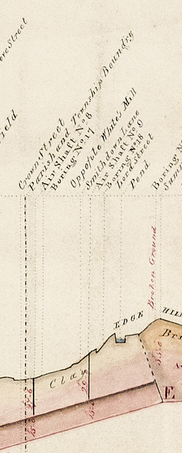
Quite when the mill was built is unclear. It is not shown on Horwood's map of 1803 but does appear on Gregory's map of 1806 which shows a cluster of buildings, one characteristically circular in outline, at the junction of Smeatham (sometimes Smedons and later Smithdown) Lane and Crabtree Lane. In Swire's map of 1823/4 the mill is definitively represented by a windmill-like symbol. The total area occupied by the mill parcel was about 5300 sq m. The mill at this time was about 100 m from the junction of Smithdown Lane and Falkner Street and it remained at this location until at least 1864.

Gage's map of 1836 shows the complex of buildings around the mill. At the foot of the triangular mill parcel is the L&MR's Millfield works where wagons and carriages were built and maintained. The boundary with the mill parcel may have been marked by an embankment and high retaining wall that subsequently marked the boundary of one of the merchant coalyards. There is a curious bulge midway along the wall that coincides with one of the gridlines on later maps and hence may have had some cartographic significance. Alternatively it may represent a structure such as a chimney that was part-located on land leased from the mill.

On the mill side of the boundary is a row of small sheds . These could be stables, perhaps some rented out to the L&MR and hence the proximity although noise and smoke from heavy metalworking would have been disturbing for animals. The mill itself appears skirted by buildings, presumably for reception of wheat and storage of grain pending collection. There appears to be a driveway emanating from Falkner Street with separate entry and exit. This was presumably hardened in some fashion to cope with the frequent passage of carts.

Behind the mill are two rectangular structures with similar edge-hatching that might have been water reservoirs. The mill is known to have pumped water and supplied it to the station (Thomas, 1980).

Moving further towards the road junction, there are a number of houses on Falkner Street. White lived at number 8 so his may have been the one nearest the mill. There is a much larger building at the junction itself as well as a possible short terrace. It is possible that these were also residential, owned by White but rented out.

The building on Smithdown Lane is shown in subsequent maps as a smithy. The presence of numerous horses working in the locality would have meant steady business for a farrier on top of any work done for the mill or railway.

The mill parcel in the mid-1840s

By the mid-1840s the mill parcel appears to have lost several buildings, including the reservoirs but this may presage further development. The railway notably makes its first incursion onto the mill parcel. There are now four tunnels under Smithdown Lane besides the original Stephenson tunnel (which was too small for locomotives) and track from one snakes across the northern edge of the mill parcel and into or up to the side of the entrance building for the Millfield yard. A siding forks back off towards Smithdown Lane and towards the expanding smithy on the mill parcel, presumably delivering coal and iron.

The mill parcel in the late 1840s

The Town Plan of 1849 shows the mill now enmeshed in a complex of sidings with at least 6 visible turnplates. It now had a substantial reservoir to its north. The presence of a weighing machine suggests that there might be an adjacent hut under a raised reservoir. There were large numbers of buildings of differing sizes as well as an augmented complex associated with the mill itself.

There is no definitive visual representation of the windmill in this location other than a very distant appearance in the 1847 panoramic view published by Ackermann. This suggests the tower format (rather than post) with perhaps a hemispherical cap. It appears to have a warehouse to its south fully within the boundaries of the combined railway and mill yards. By this time there were already quite a few buildings on Falkner Street interspersed with walls and presumably gates.

There is a large 5-6 storey warehouse on Falkner Street that appears at this time and which persisted until the yard was decommissioned. The convoluted nature of the mill sidings suggests that rail traffic was segregated, inward movements to the east of the large warehouse and outward to the west.

On the eastern side, although no entrance or interior track is visible on the map, there may be track into the mill from a complex of sidings, perhaps used for prioritising wagons. Alternatively the mill buildings adjacent to the siding may have had unloading bays. In either case movement of wagons away from the mill would appear to interfere with inbound wagons unless rakes were relatively short in which case half the wagons could back up past the turnplate while the second half took their place. [UPDATED 04/04/18]

There may also be track from the mill into the warehouse. This could be entirely separate or linked by two turnplates within the building. It is also possible that this is a chute rather than track. In either case it raises the possibility that the warehouse was used to store flour, at least while it was in close proximity to the mill. Later yard plans made after the mill had relocated eastwards (see below) indicate use of the warehouse as stables although other roles would clearly be possible for the upper storeys of such a large building. An aerial photograph from 1922 shows that there are exits from the warehouse to Falkner Street. There is also a siding on the eastern side of the building which does not run adjacent to the warehouse and is presumably for direct transfer of goods to carts. A weighing machine is provided close to the gate. [UPDATED 04/04/18]

On the western corner of the parcel adjacent to Falkner Street is a building with track inside. This may be an engine house. The adjacent building might be offices and overnight accommodation for enginemen. The locomotive could belong (or be leased to) the mill but several branchlines were operated to a large extent on behalf of collieries with the Bolton & Leigh, for example, purchasing Edward Bury's Liverpool engine. The locomotive shown here is based on Bury's later tank shunter delivered to the Chester & Shrewsbury in 1847. Bury had a successful business in Liverpool producing small, simple and inexpensive locomotives such as this coupled 0-4-0. Most likely, however, local shunting would be carried out by horses, typically drawing a maximum of three wagons at a time.

There is a siding that runs close to the mill buildings and this could house a loading bay, most likely outbound.

Grain shipment by rail to Crown Street for milling might reflect changes in agricultural practices around this time. As the city expanded into the countryside with loss of adjacent farms and fields so the railway enabled more distant farms to send grain for milling in the city. These may even have included reclaimed areas such as Chat Moss where William Reid grew wheat in the early 1830s.

Grain would typically be in sacks stacked on low-sided wagons, perhaps covered with a tarpaulin secured by rope. A wagon likely carrying sacks can be seen in one of Shaw's 1831 train prints with a rider apparently in repose on top. In the OpenSim build the wagons have a bar to simplify coverage with the tarpaulin.

In due course Liverpool would also import grain from the Americas. This came in bulk, mostly into Waterloo docks. In 1849 these were connected to Edge Hill, and thence Crown Street, by the Victoria and Waterloo tunnels. While there is obviously a danger of reading too much into the model, it would appear that the mill and warehouse may have been part of an operation that both produced flour and distributed grain, indicative perhaps of the corn merchant-cum-miller that White became. One can imagine encouragement for such an enterprise coming from L&MR-associated corn merchants such as Sandars and Booth. In time, however, large grain warehouses and modern mills were built close to the northern docks and this may have impinged on White's business strategy and led to increased coal traffic.

Braithwaite Poole, writing in 1849 on behalf of the LNWR, had predicted that the weight of coal passing through Crown Street would double over the next 5 years to 1849 and recommended that space for coal at Crown Street be expanded by removing the buildings of the old Millfield Yard. There is no mention of the mill parcel itself apart perhaps from an oblique reference to subletting land on which they are presently tenants (the comment could equally apply to yards on the opposite side of Crown Street). It is possible therefore that such sidings as there were on the mill estate were leased to the railway who would now expand the coal operation to third-parties via the Wigan Coal & Iron Company and their agents.

The mill parcel in the 1860s

smithdown lane junction with falkner st.png
Fig: The windmill has moved and now has a steam-powered mill alongside it

By this time there had been a radical change as shown in Herdman's 1859 watercolour. The mill has moved to about 30 m from the junction and the chimney on the right belonging to the smithy is now accompanied by another chimney, probably one serving a boilerhouse driving a steam-powered mill built in the mid-1850s. [UPDATE: SEE COMMENT AT END; APPARENTLY THE MILL DID NOT MOVE]

There has been a suggestion that the chimneys belong to the Windsor Foundry (pdf) associated with pioneer socialist John Finch. However, while the smithy may have been a subsidiary site, the main Windsor Foundry location developed from one previously owned by Smith & Willey further along Smithdown Lane (opposite to the direction shown in Herdman's picture). Later still this would become Milner's Phoenix Safe Works.

The Herdman print shows a standard tower mill with a pitched roof cap that rotates to face the wind by means of a small fantail rotor to the rear. The structure is also shown in the distance in an 1865 panoramic view although the roof does not appear conventionally pitched, more an ogee with a finial.

The buildings to the left in Herdman's print may be residential and/or office spaces and probably include the earliest cluster at the junction. The building with the facing gable end is presumably the warehouse seen to the right in View 1 (below) and used in preference to the original warehouse.

The chimney to the left appears in Ackermann's 1847 panoramic view of Liverpool, probably associated with Millfield Yard. It no longer appears in the 1865 panorama of Jackson & Sulman. The spire just to the right of the mill may be that of the Church of the Holy Innocents on Myrtle Street although this only opened in 1861.

The 1865 panorama by Jackson & Sulman again shows the windmill dominating the coalyard but, as with Herdman's print, significantly closer to Smithdown Lane. There is again a warehouse to the south but the slightly different angle makes it hard to resolve buildings along Falkner Street and beyond.

Lancashire Archives has a map of the coalyards by William Culshaw that probably dates to this period but it excludes the mill parcel. Other maps show that there were three main yards on the mill parcel, one belonging to Bathgate, one to Bradley (both Liverpool coal merchants) and probably one ultimately to the Wigan Coal & Iron Company who were responsible for track at the entrance to the mill estate and may have supplied the two merchants in the meantime.

There is a useful guide to the development of Liverpool warehouses.

The mill parcel in the 1890s

Although the circular outline of the mill is no longer evident on maps from 1891, there is still a cluster of buildings at the junction of Smithdown Lane and Falkner Street. It was only from 1908 that both mills had disappeared completely.

Three photographs of the Falkner Street mill c1900 are available in Liverpool Archives. Assuming they relate to the mill in question (UPDATE: THEY DON'T; SEE COMMENT AT END), they are potentially very useful albeit that they show the mill as largely derelict, roofless and possibly fire-damaged. This is consistent with the eventual disappearance of the mill from maps around this time.

View 1: 352 PSP/120/5/1: This shows a view across a lawn with the derelict mill behind a wall with a gate. This suggests that the garden is part of the complex or, alternatively, that the road, probably Falkner Street, lies between the gate and mill. There is a large warehouse to the right with two ladders leaning against it. It seems to have space below to receive or store vehicles (carts, etc). There is a cluster of smaller buildings to the left together with two gable ends of a much larger building. In the background is a large chimney, possibly a replacement for the two in Herdman's print. Looking north?

View 2: 352 PSP/120/5/2: This shows a related view with a house in the background, possibly the one with the garden seen in the earlier photo or, perhaps more likely, on the other side of Falkner Street where there were numerous pubs and hotels fronting densely packed court-style housing. The smaller buildings to the left include steps leading to what appears to be the mill entrance although the previous view shows it as largely self-standing. The building looks relatively new by comparison with its surrounds; perhaps it has just been painted and hence the ladder. Looking south, east or some point between?

View 3: 352 PSP/120/5/3: This image is more difficult to place and may represent a different mill or an earlier view of the same mill with a water jet being used to dampen down buildings after a fire. While the mill looks equally derelict and fire-damaged, it is possibly less squat, less sullied and has remnants of sails. No other buildings from the previous photos are clearly visible. An intriguing possibility is that this is a much earlier photo of the original windmill which is still apparent on maps dating to 1864 but gone by 1896. The building may represent the loading bay previously mentioned or an access point for track into the mill complex.

Lancashire Archives have plans by Culshaw for extensions to the mill (warehouse, reservoir; mentions of stables and offices). Unfortunately all but the one mentioned above were unavailable for inspection due to their poor condition. The one that was available references a small building adjacent to a large area for horse manure suggesting proximity to the stables.

William Fairbairn's steam mill

Dependence on wind as a source of motive power for milling meant that productivity was low during periods of low winds. As these often happened during summer when watermills might also be suffering from dried up streams, the promise of continuous operation via steam must have been very attractive.

The steam mill was based on engineer and millwright William Fairbairn's design of a ship-borne mill supplied to the Royal Navy during the Crimean War (Fairbairn incidentally is best remembered in the context of the L&MR for his role in the design of the Water Street Bridge in Manchester). The mill was installed in HMS Bruiser (1855; originally built in 1854 as HMS Robert Stephenson) and routinely ground some 20 tons of locally sourced wheat per day, the flour being used to make bread by a companion vessel HMS Abundance. Although the components were not unusual apart from being adapted to work at sea, Fairbairn comments on the excellent reliability of the mechanism, its highly automated operation and the good quality of the product from sometimes indifferent sources, all attractive propositions for the Liverpool millowner. An overview of mills operating in Liverpool comments on the high quality of the product from the steam mill, at least while White supervised operations personally.

It follows that construction by Fairbairn at Liverpool likely occurred sometime after 1855 but probably before Herdman's print dated 1859. Indeed, the juxtaposition of the old and new mills may have inspired the painting.

There is further information on Liverpool mills, including "Crabtree/White's" mill at the Mills Archive in Reading.

The OpenSim model
Windmill 1849 from west with engine.png
Reimagining the windmill parcel of 1849: view from the west. The engine house is on the extreme right, just out of sight. The proposed loading platform for the mill is just to its right. To the left of the mill is a raised reservoir and in front of that a refuelling/watering station. Wagons for the smithy and adjacent coalyard approach via the entrance on the extreme left and pass around the mill complex. The smithy's chimney can be seen in the distance. This is the reverse view to the one at the top of the page.

The 1849 Town Plan was used to inform an OpenSim build. Very much a work in progress, the build is intended to support a narrative consistent with the Plan.

Thus far little has been done to incorporate topographic features. As the coalyard expanded so the associated land would need to be levelled. It may be that the mill and its environs were at a slightly higher level than the coalyard and that retaining walls were built at the changing boundary. These perimeter walls may have been retained after land on both sides was made level. Three are evident on the 1890s map. The initial entrance was probably on Falkner Street so it is possible that the land was levelled at 166 feet as opposed to the 172 feet at the junction. This may explain the sunken appearance of one of the buildings in Herdman's print. Subsequently another entrance was made on Smithdown Lane but it is not clear how the disparity in height was managed other than by, of course, a slope. The same issue would apply if coal was supplied to the smithy from the early sidings.

The last days of the mill

In 1880 the Crabtree Lane Flour Mills were advertised in the Liverpool Mercury as being for sale in working order when, presumably, Stephen White and family decided to cease operations there. By this time the technology had in any case moved on to roller-based milling. According to the advertisement, the parcel of some 7293 square yards had a plentiful supply of well water and included coalyards, houses, shops (presumably the offices of coal merchants as well as workshops) and a wheelwright's yard (possibly part of the smithy). This appears to confirm that Stephen White had not sold land to the railway but had instead consolidated his business activities in one corner of the parcel and converted the remainder to coalyards that were sub-let. Over the years he had actively engaged with the opportunities the railway afforded him.

A plan dating to 1916 still fails to show the mill parcel as assigned to LNWR although its tenants Bradley and Bathgate are indicated. Another, probably later but still LNWR so pre-LMS merger (in 1923), now shows the LNWR boundary as extending around the mill parcel and only Bathgate is cited as merchant (thanks to the Liverpool & Manchester Railway Trust for posting these). The best guess then is that the LNWR finally acquired the site sometime between 1916 and 1923. The interim owner is unknown but presumably worked with the LNWR to clear the remaining buildings and extend the coal sidings.

Although starting as a miller and working the mill parcel creatively, Mr White subsequently developed a parallel business as a corn merchant. In 1875 he was based at 3 Fenwick Street (conveniently situated for the Corn Exchange in Brunswick Street). Although he kept his interest in the mills, he moved away from what had doubtless become an industrial rather than pastoral location (his original house was probably demolished) to less polluted areas of, variously, Edge Hill, Fairfield (Beech Terrace) and ultimately Wavertree (Derwent Lodge). He was probably quite successful and his name appears emboldened in the trade directory as well as featuring in newspapers as a generous benefactor to local good causes. By this time, however, he had presumably passed on operation of the mill to a manager.

He died at Derwent Lodge on August 7th 1883, aged 82.

IMG_20180221_132725.jpg
Fig: Crown Street Park in 2018 at junction of Falkner Street (left, hidden) and Overbury Street (right). Smithdown Lane followed the line of the path leading into the park so the lefthand part of the photo roughly equates to the view in the Herdman picture.

[UPDATE from Gareth Williams: unfortunately the three photos in Liverpool Archives have all been miscatalogued. The first two are Wellington Mills, Wavertree, photographed about 1895 just before they were demolished, and the third is Woolton Mill, on fire in 1898. Herdman's painting is probably the most reliable image of the windmill as it appeared when working (it matches what is known about the characteristics of tower mills in the Mersey area, having a gabled cap, cloth-spread sails and a chain-and-wheel system instead of a fantail, to turn the cap into the wind) The windmill wasn't moved after 1851 but was always in the same location.]

The other station at Liverpool Crown Street

liverpool crown street goods station 7.jpg

Fig: Liverpool Crown Street goods station as it may have looked in the late nineteenth century.

People who look at old maps of Liverpool are sometimes confused by the presence of a station east of Smithdown Lane. They think that this must be a remnant of the 1830 Crown Street passenger terminus of the Liverpool & Manchester Railway (L&MR). It isn't, it's the less famous but much longer lived goods station.

By the time the goods station was built, probably sometime 1843-6, the passenger station was already history. The goods station may have arisen from an attempt to boost freight traffic coming out of the economic depression in 1840-41. Donaghy (1972) also mentions enhanced competition with the canals for freight during this period. The L&MR appointed a special agent to encourage Manchester businesses to make more use of rail for freight. On the other hand the Crown Street station was small by comparison with the facilities at Wapping unless there were, as with coal, specific advantages in shipping to a relatively elevated location where carters had gravity to help them on their way. Providing a parcels service to residents local to the station, including shops and light industry, would be more in keeping with its size and increased economic activity in the neighbourhood.

What little we know of the early goods station comes via Braithwaite Poole, northern traffic manager of the LNWR (London & NorthWestern Railway) who first appears on the scene with the Grand Junction Railway (GJR) into which the L&MR merged in 1845. In that year Poole wrote a rule book for operation of the Liverpool goods services at Wapping, Edge Hill and Crown Street. It would appear from the guidance that the goods focus at Crown Street was on steam packet ships and sailing vessels, perhaps particularly bulky luggage and parcels beyond the remit of both Wapping and Lime Street (which was supposedly passengers only). Whatever the niche, the business does not appear to have thrived and Crown Street goods station became an empty package depot sometime before 1849 when Poole made a further pronouncement. Note that there is no mention in the rule book of a building, just a yard, although the existence of one does seem likely if only for security reasons.

In 1846 the GJR merged into the LNWR and a second (southern) tunnel to Crown Street was opened up from the Chatsworth Street (Wapping) cutting. This allowed locomotives to access Crown Street for the first time, the roof of the Stephenson tunnel being too low. Presumably part of the goods yard had already been levelled by this stage and was accessible from Crown Street via a tunnel under Smithdown Lane; ultimately there would be a total of four tunnels added, three of which are shown in Jackson and Sulman's panoramic view of 1865.

In 1849, Braithwaite Poole, now with the LNWR, wrote a report proposing a renewed focus on coal in Crown Street and Liverpool more generally; the empty package depot had been transferred to Liverpool Waterloo goods station by this time as most of the packages were due for return to Ireland or Scotland by ship. Apparently a difference in level with the adjacent coalyards precluded the yard's incorporation into mainstream coal activity (further excavation was considered too expensive). Instead, the Crown Street goods station was to specialise in potatoes. Whether the change took place is unclear as the company subsequently developed a separate agricultural depot for potato merchants at the northern end of its estate, possibly because the activity proved so popular. Coal, of course, became the mainstay of the remainder of the estate once the buildings of the old Millfield works were demolished.

Appearance and types

In general the appearance of the goods station building can only be guessed at as no detailed plans or images are readily available. In some ways this seems surprising given that the building was demolished within living memory but this area was overshadowed in terms of heritage interest by the main Crown Street yards and, in particular, the Stephenson tunnel. The one image found to date shows the 1849 tunnel in the distance (this tunnel is still visible today) and the foreshortened northern and truncated western aspects of the goods station on the right. The goods station can also be glimpsed briefly (00:43) in a video of the excellent model of the yards in their latter years although little detail is evident apart from the gabled roof.

According to Minnis & Hickman (M&H; pdf), however, such buildings tended to be of a limited range of types and the Crown Street station appears to fit one of the types reasonably well. Thus it seems to have had a through track on the northern side with three loading bays at the rear under small canopies (at least from the 1860s) plus an external office (as shown in M&H Fig.21.c).

UPDATE (27/03/18): Although I have yet to view high resolution copies, there are two aerial images from the early 1970s that show the yard. One is rather distant but the other shows a little detail of the roof (the station as-was is bottom right and now accompanied by other buildings on the same parcel). It confirms that there are skylights but suggests four rather than three sets per side (presumably, and more logically, above areas not adjacent to the loading doors). There is a possible chimney at the junction of the two buildings as expected. The extension (see below) appears to be single storey and have a flat roof.

UPDATE (30/03/18): There is a much better aerial photo dating to 1922. It suggests that the individual canopies may differ from the style shown in the model, that the larger canopy was pitched and that the extension continued the main roof with a second gabled roof in parallel, both with single skylights and three windows on the south side. The office also has a pitched roof (mono or dual unclear) and the chimney is probably adjacent to the door with a window on the oblique wall.

The sequence of development

The first development in this location preceded the goods station, however. A short spur ran down beside Smithdown Lane and across the road junction with Falkner Street to what became Mersey Works, a granite and quartzite specialist. Hence, when it came to build the goods station a compromise had to be made because of this track, resulting in an obliquely truncated office. As this makes a pitched roof awkward, I have assumed the roof to be flat even though the main roof is monopitched.

There was about 1.5 miles of track over 6 acres at Crown Street in 1849, the layout was fairly complex and access to the goods station would have required a certain amount of shunting although the odd wagon could be accommodated by means of a series of turnplates allowing lateral movement across the tracks at the eastern end. This track extended beyond the building so direct transfer to a cart from a single wagon would also be possible.

By the 1890s, however, perhaps as turnplates fell out of favour, this facility had disappeared and the through track terminated in a buffer at the eastern end. Canopies were also added to the loading bays by this time.

In the early 1900s, the through track was removed and the internal platform likely extended over the space vacated with a narrow external platform now reaching out to the track beyond (a hybrid with M&H Fig.21.g). A much larger canopy covering two of the external loading doors was added together with an extension to the building at the eastern end to Overbury Street (the extra canopy did not last for very long). The extension is not obvious in the photograph suggesting it was probably single storey though it is perhaps suggestive of a dual purpose goods station and warehouse facility. M&H suggests that this type of arrangement typically had large sliding doors leading onto the platform. One door is evident on the photograph.

The goods station building may have fulfilled various roles over the years, including a return of the empty package depot in the 1890s, an affiliation with Warrington brewery Walker's in the early twentieth century and in the 1970s as a bottling store, probably for a nearby soft drinks manufacturer.

Further expansion may have been constrained by the presence of the track running to Mersey Works. When such traffic ceased (by the 1920s), additional buildings appeared to both east and west. However, by the 1980s the map shows the complex simply as "Works". Of course, some people may be familiar with the original building and it would be interesting to hear how much the actual structure diverged from that proposed here.

The OpenSim build

As ever, this is a scratch build, conjectural and a work-in-progress.

The distant photographic view of the goods station suggests that it had a monopitch roof, a rectangular opening for the through track (with a jack arch) and a single opening midway along the northern facade, at least in its later modified form. The jack arch suggests that the building might have followed the LNWR house style of the 1880s with arches forming a blind arcade on the north and south sides except where doors were present.

There are relatively few extant warehouses of comparable size and period in the north-west although Earlestown (Google Maps) has one from the turn of the century and some features (continuity of roof and canopy, skylights, flat roof to office) have been copied although some may, of course, have been later modifications. For comparison, the Crown Street building (less office and extension) was about 40x11 m while the Earlestown equivalent is slightly larger at about 45x17 m. The Earlestown office lacks an obvious chimney which may have been removed at the same time as its pitched roof. A chimney has been added at the interface of the office and main building in the Crown Street build inspired by the cutaway drawing in M&H (p.24). Presumably this would have provided a modicum of heat to the main building as well. According to M&H, LNWR was slow to standardise its house styles so the three louvred ventilation windows on the gable typical of later buildings have been omitted (they are also absent from the Earlestown structure). It would be unusual, however, not to have had some form of decorative brickwork on the gable ends.

Lost and largely forgotten

It is a strange paradox that the goods station survived so long, over a century, when the passenger station lasted just six years. The latter, of course, was ultimately a victim of its own success while the goods station seems to have often been a building in search of a purpose. Its simplicity, and hence versatility, may have been a virtue in that regard.

Although some attention has been paid to other railway heritage assets on Merseyside, the goods station has understandably been neglected. Its loss, however, is regrettable given its age (built c.1846-9) as there appear to be no comparable LNWR buildings dating to that era. Of course, it would in any case have remained in the shadow of the large 1830 warehouse at Manchester Liverpool Road but its size and location might have been appropriate for a small railway heritage museum associated with Crown Street, the tunnels and the cutting (the same applies, of course, to Edge Hill station).

The site is now a children's playground within Crown Street park.

Liverpool and the Great Exhibition of 1851

A recent update on the Great Exhibition of the North piqued my interest in Liverpool's contribution to the original Great Exhibition of 1851.

I previously blogged the model of Edge Hill at the National Railway Museum that was built for the 1886 "Shipperies" exhibition; the large building housing the exhibition is also an OpenSim work-in-progress. The Shipperies was Liverpool's first foray into the major league of international exhibitions promoting trade and industry and the inspiration for this was the Great Exhibition of 1851 held in London in the immense Crystal Palace designed by Joseph Paxton and built in Hyde Park. It turns out that there was a Liverpool model there as well and many of the contractors and engineers who started out in Georgian Liverpool would meet once more in London.

The Great Exhibition of 1851

As with the Shipperies, the name was a shortened form, the full name being The Great Exhibition of the Works of Industry of All Nations (it was sometimes called the World's Fair as well). It was championed by the royal consort Prince Albert but nevertheless was a hard sell, not least because those local to the park were loathe to see their tranquility disrupted by an international exhibition. Finance was an issue as well and the organisers resorted to the Victorian equivalent of crowdfunding, public subscription.

The form of the exhibition hall was also problematic. A design competition was held and there were some 240 entries, including one from Liverpool-based architect William Raffles Brown. Unfortunately, none of the entries satisfied the eminent Building Committee which included both architects and engineers, most notably Stephenson and Brunel. In the absence of a clear winner, the Committee opted to create their own design based where appropriate on elements from competition entries. The end-product unsurprisingly looked as if it had indeed been designed by a committee and, being brick-based, looked more permanent than temporary, much to the dismay of locals. The project was in trouble.

Rescue came from an unexpected quarter. Noted gardener and greenhouse designer Joseph Paxton mocked up the outline for a glass-based building that would eventually become known as the Crystal Palace. Plans were completed in 8 days and were popular with the public, one benefit being that the elm trees in Hyde Park could be accommodated by the high roof in the transept (legend has it that Brunel gave Paxton the necessary measurements). Championed by Stephenson, the new design was adopted and the building completed within 9 months ready for the opening on 1st May.

Samuel Holme of Liverpool (builder for St George's Hall and part of the original Lime Street station) was invited to bid for the building contract but declined. Instead, the Birmingham firm of Fox, Henderson & Co. took on construction of the modular design (they had already done Birkenhead Market and Liverpool Exchange Station) with many of the operations semi-automated using machines devised by Paxton. William Cubitt acted as Principal Engineer. Most of the sheet glass was produced by Chance & Co. in Birmingham but some was also made in St Helens by Pilkington Brothers, presumably to help meet a tight deadline.

The finished design was based on modules comprising 24 foot squares with 36 in the west nave and 38 in the east. The two were separated by a transept running north-south. This was 3 squares wide so the final length was probably 1848 feet (563.3 m) rather than the more symbolic 1851 widely quoted. The naves were tiered such that there were additional galleries and courts running alongside the main nave with a second storey of galleries above.

Liverpool at the Exhibition

As might be expected, Liverpool was well-represented at the exhibition, not least by a large (15 x 2.5 m) model of the docks and commercial quarter. The image below comes from the exhibition catalogue (just one of three volumes). Liverpool also had a large display of the raw materials imported through its docks with copious details listed in the official catalogue (Hull had a similar display but no listing).

These displays were coordinated via the a local committee working out of the Town Hall but in common with other towns and cities, Liverpool's citizens had individual displays of manufactured goods as well as tools and raw materials. Joseph Mayer (subsequently a benefactor to the Liverpool museum) had a large and expensive display of decorative items including tableware, inkstands and jewellery, and Milner's of Smithdown Lane had a display of their fire-resisting safes in various stages of manufacture. Other artefacts with a Liverpool connection included the architect's model of St Georges's Hall, a model of the Lime Street station train shed, a model of a railway bridge in Chepstow made by the Windsor Foundry to Brunel's design and an invention by noted local artist WG Herdman to assist the novice with perspective drawing.

Liverpool model at Great Exhibition of the Works of Industry.png

Fig: Case and map of the Liverpool model displayed at the Great Exhibition

The model was displayed in the West (British) Nave and can be seen on the left in the print published by Dickenson below as well as in a similar view by Joseph Nash in the Royal Collection. It is readily recognised by the model elephants supporting alternate legs of the case.

Dickinsonscompr1_0219c.jpg
Fig: The west (British) Nave at the Great Exhibition on opening day. The case containing the Liverpool model is on the left.

Liverpool exhibit at Royal Exhibition (c) Victoria and Albert Museum 2011EU2401_2500.jpg

Fig: Closeup of the model case in painting by Edmund Walker (c) Victoria & Albert Museum.

Details of the model and its construction

The model represented 5 miles of dock frontage and a third of the town, a total in excess of 300 acres. The scale was 8 inches to the mile. It included not only detailed models of buildings but also people, animals and vehicles. Doubtless the model would be of interest to those who already knew Liverpool as well as those who were aware of its commercial significance and wanted to know more. Of course, some would simply be impressed by the size and quality of the model. To ensure that the message got across, the model had an index map and a table reviewing the development of economic activity mediated by the docks.

The model cost £1000 to construct, about £100000 in present day terms. Its financing is a little obscure. In contrast to earlier state-sponsored events in France, the 1851 Great Exhibition was a private venture and hence neither politically partisan nor a drain on the public finances. Some Liverpool merchants were happy to contribute to the general cost of mounting the exhibition but were less enamoured of funding Liverpool's entry. In some quarters there was an expectation that the Corporation and Docks Committee would provide the bulk of the finance while others saw the whole project as ill-founded and refused to have anything to do with it. At one stage there was a shortfall in the monies required for construction of the Crystal Palace itself and hence doubt as to whether the project as a whole would come to fruition. A degree of evangelising by the central organising committee, some financial guarantees centrally plus advocacy locally by the liberal Liverpool Mercury newspaper eventually saw the Liverpool project funded.

Construction of the model was supervised on behalf of the local committee by engineer John Grantham. The designer and contractor was architect William Raffles Brown. Architectural and marine model builder David Graham was in charge of the 24-strong team doing the actual building variously in wood, cardboard and paper. Some 1500 sailing ships and 120 steam vessels were made. Water was modelled using St Helen's glass tinted green, unground on its upper surface to represent waves and silvered on the lower to permit reflection. The modellers included both men and women, the latter responsible in particular for fine detail (people in the model were the size of the very tip of a pen nib). The case was designed by Grantham and manufacture contracted to the firm of Samuel and James Holme (Samuel Holme would be elected Mayor in 1852-3).

While the major elements arrived in London in good time for assembly and last-minute modifications, construction of the model ships, including the Great Eastern, continued in a (rent-free) room on Liverpool's Lord Street above Milner's. Completion must have been close to the opening itself. This was probably not unusual as there was a general feeling among exhibitors that the opening would have to be postponed until, of course, a tremendous panic ensued when it proved not to be the case.

Visiting the Exhibition

Locomotive Liverpool as displayed at the Great Exhibition 1851.png

Fig: Full-size LNWR locomotive Liverpool was also on display. It won a prestigious Council Medal in its section. The class came into service in 1847 and was credited with speeds up to 78 mph although at the cost of some damage to the track.

Railways played a prominent role in the success of the exhibition, both in terms of transport of exhibits and visitors. Unsurprisingly locomotives were among the exhibits as was ancillary railway equipment. Even the Liverpool docks model showed multiple railway stations. One limitation of the Hyde Park site, however, was the absence of a convenient railway station!

Although the Great Exhibition opened on the 1st May 1851, the doors had been temporarily opened some weeks previously to those curious to see the building before exhibits were installed; monies from this went to workers injured during construction. When it opened, the exhibition and associated events proved highly popular and attracted some 6 million visits (including multiple visits using a season ticket). Of these, probably 4 million originated from outside of London, many arriving by train. Although excursions had been an early feature of the Liverpool & Manchester Railway back in 1830, the success of the Great Exhibition was founded not only on subscription clubs mounting special excursions but also on low return fares as a result of cut-throat competition (5 shillings for a return adult fare travelling Third Class from York, equivalent to about £25 now) as well as low entry prices on selected days (1 shilling or £5 now). Enlightened employers would provide assistance to their employees to enable them to attend.

Travel agent Thomas Cook also organised visits to the Great Exhibition. Some 350,000 people travelled from Yorkshire and the Midlands on his rail excursions and he published his own newspaper, Cook's Exhibition Herald and Excursion Advertiser, which ran through to 1939 as the (recently revived) Excursionist.

The exhibition experience

The exhibits were organised in four major groups (Raw Materials, Machinery, Manufactures, Sculpture and the Fine Arts) subdivided into some 30 classes. As far as possible exhibits were arranged geographically although those from Great Britain & Ireland (as it was then) were joined in the West Nave with their colonies, supposedly according to ambient temperature.

There were some 100000 exhibits and 14000 exhibitors so a description is beyond this blog even if those numbers are subject to a degree of "interpretation". Many books were published both at the time of the exhibition and after but a partwork (incomplete) gives a good impression of the exhibits and visitor experience.

One aspect worth noting, however, is that the exhibits included the first ever photographic exhibition and, of course, many photographs and daguerrotypes were taken both of the building and exhibits. These included stereotypes that incorporated two images and hence gave a 3D effect when seen using a handheld viewer. Nevertheless, the lithographs and watercolours, some based on daguerrotypes, remain invaluable in terms of detail and colour. Despite the reference to Fine Arts, paintings themselves were excluded from the Great Exhibition and a separate private initiative, the General Exhibition, attempted to form a gallery of contemporary international art in Lichfield House.

Setting for the Liverpool exhibits

The Liverpool model was at the far end of the Nave adjacent to the west entrance and hence a good distance from the principal entrance on the southern end of the transept. The imports exhibit of some 2000 items was in the gallery above the Nave and was estimated to require five display cases each 40x5 feet. Whether this was forthcoming is unknown but there may have been constraints on floorspace in the galleries. Photographs of the vegetable product display in the Scottish gallery show a vertical case being used.

The role of the east and west entrances is unclear although they appear to have supported paid entry so were not confined to season ticket holders (there was a separate entrance queue at the main entrance for this group of visitors). Presumably the entrance would at times have provided a welcome draft in what was frequently a hothouse atmosphere. The fountains may also have contributed to a cooling effect.

Walker's painting suggests that seating adjacent to the model case was very popular. One (possibly over-enthusiastic) estimate suggests that there were some 21 miles of aisles to negotiate with daily attendances often of the order of 50000 (maxima 110000 per day, 93000 concurrently). Calico linings to some of the roof would moderate the greenhouse effect but clearly the occasional break would be welcome (there were refreshment areas to the north as well). Of interest would be the two mirrors attached to the western end of the Nave, said to be the largest in the world at that time. There was also an organ above the entrance so on occasion there was an opportunity to listen to music (each entrance was similarly equipped).

The impact of the Liverpool model is hard to gauge but its size and subject likely guaranteed a good audience with positive coverage in guidebooks and newspaper reports. The importance of the topic and city merited the model's inclusion as part of an activity for young people in an educational tour of the exhibition. On the other hand a series of lectures to accompany the exhibition petered out for lack of audience.

Did the exhibits garner further trade for Liverpool? The economic impact of the exhibition overall is frequently held to be slight. Although it made a profit (and put pressure on hotel accommodation), it drained other aspects of London's economy, the theatres being especially hard hit. Selling in the exhibition was expressly forbidden but the prints suggest exhibitors were present to answer questions. There is no record of an attendant supervising the Liverpool stands but presumably someone must have been responsible for polishing the glass on the display cases if nothing else.

Both Liverpool exhibits won Prize Medals at the end of the exhibition. Originally there had been some suggestion that monetary prizes would be awarded but this mostly fell by the wayside, presumably in the interests of economy. Companies winning medals used the information in advertisements. Doubtless the Liverpool local committee could see them as an index of a job well done.

The impact of the Exhibition in Liverpool

For those unable to attend in person, there were opportunities during the summer to see a model of the Crystal Palace (at 34 Church Street) and to experience "being there" by means of a panoramic picture of the inside of the building at the Zoological Gardens. Newspaper adverts encouraged prospective visitors to buy new clothes before going to London and exhibitors sold their display wares at the end of the run (or copies thereof).

The exhibition ends

The exhibition closed on 11th October. It subsequently opened for two further days gratis to exhibitors only and then for the formal announcement of prizes. The good news was that it had made a significant profit and this was invested in the establishment of a set of permanent museums in Kensington which continue to the present day. There was some deliberation on the fate of the Crystal Palace itself but the intention had always been that it would not stay in Hyde Park. Ultimately it relocated to Sydenham (actually Penge) where it remained in a somewhat modified albeit much larger form until 1936 when it sadly burned down. There have been suggestions that a copy of the original Crystal Palace might be built at Sydenham or as part of a national capital of culture bid at Coventry. Not everyone thought this a good idea.

The fate of the Liverpool model may have followed similar lines. Part of the rationale behind investing in its construction was that the model later be used in a museum to illustrate the commercial importance of the city. Accordingly, when it came back to Liverpool, the model was displayed in the newly opened Derby museum (pdf) at the corner of Slater Street and Parr Street. Nearby was a smaller model of Liverpool in the mid-C17. Its provenance is unclear although there were early suggestions that such a model would be a useful complement to the model displayed in London. It is possible that there was insufficient space allocated for both to be on show in London.

union library with museum.jpg

Fig: The former Union Newsroom by John Foster Snr (centre). The first city museum was in the building to the right behind it on the corner of Parr and Slater Streets.

The current museum opened to the public in 1861 on William Brown Street (named after the principal benefactor). The models were supposedly assigned to two rooms in the new venue but the museum history is obscure as to their eventual fate, much being lost as a result of bomb damage during the Second World War.

The present day

The excellent museums in Liverpool continue to make excellent use of models similar to that displayed in London and in many cases they are interactive. One of the most recent and engaging is the digital city model at the RIBA North.

IMG_20170623_163539.jpg

Fig: The interactive Liverpool model at RIBA North

The OpenSim model

This simple build used a script to replicate a transverse section 35 times (there is some variation in section width to the north side that is not modelled). The result would need extensive editing to generate the courts and staircases but even without content, decoration and precise measurements (beyond the 24x24 ft unit), the model still gives some idea of the environment and adds additional context to some of the lithographs.

Great Exhibition west nave from south gallery.jpg

Fig: OpenSim model of the West Nave showing the Liverpool model in situ. The transept would be in the far distance with the nave then continuing beyond.

Clearly some of lithographs were made looking from the gallery (which extended across the nave above the west entrance). It would appear that the gaps the courts inserted into the upper floor also improved lighting in areas otherwise overshadowed. The weather vane above the model had the city's name on it.

There is a venerable VRML model of the 1851 Crystal Palace from the University of Virginia that includes downloads and some nice renderings. The University of Bristol has a model of the Sydenham Crystal Palace in Second Life(TM).

Time and trains

There are a couple of nice blogs on the Museum of Science & Industry blog site about the sundial at Liverpool Road station. It has been scanned and will be available in some kind of 3D app the BBC is using to accompany its new Civilization series. I've been in equal measures impressed and perplexed by this early relic of the Liverpool & Manchester Railway which seems to pre-date the railway age. The display label passes no comment on its role so speculation duly follows!

sundial outside.jpg
Fig.1: The plinth and sundial were located above the first-class entrance from 1833.

A digression about time

Firstly, the usual caveat: I am not a physicist, astronomer, engineer or horologist.

Historically time was measured relative to the meridian, the highest point of the sun in the sky. This defined midday, the basis for apparent solar time and readily ascertained by a sundial, at least on a sunny day. It transpires, however, that the actual time of the meridian varies somewhat according to the time of year, at one time or another being 15 or so minutes faster or slower than solar time averaged across the year, so-called mean time (as in Greenwich Mean Time, GMT). The two systems are related by the Equation of Time.

Solar time varies with location and the Liverpool Road station sundial accordingly has its latitude and longitude engraved on its face. Most likely it measures the local time in Manchester although this differed by only a couple of minutes from Liverpool local time, not a big deal when trains were relatively infrequent as was the case in 1833.

Nevertheless, as lines elsewhere grew longer, busier and more interconnected, so senior railway staff started to see problems that might lead to missed connections and even collisions. Timetables (first introduced c.1838) were more complicated than they need be and mistakes by passengers were common where different parts of the journey were conducted under, say, Liverpool and London times. One possible remedy was to have two clocks, one for local and one for London time (effectively GMT), or one clock with two distinct minute hands (one perhaps with the emblem of a sun on it to denote solar).

The most sensible solution, however, was to get everyone to use the same time, i.e. GMT. Engineer John Walker raised this as an issue with government as early as 1843, recommending general adoption of GMT to regularise communications with Ireland. Henry Booth went one step further by petitioning Parliament (unsuccessfully) on behalf of the L&MR in 1844, by raising the issue within the newly merged L&NWR and by writing the pamphlet The Uniformity of TIme in 1847, the same year that GMT in the guise of "railway time" was adopted as standard by many of the principal railway companies and the cities they served.

The Great Western had in fact led the way on this by unilaterally adopting GMT in 1840. There was, however, resistance in some quarters to having this change foisted on towns by the new fangled railways and it required an Act of Parliament in 1880 to put an end to the confusion of having multiple time standards operating both within and between cities.

The significance of the sundial was that it gave a measure of time against which clocks and watches could be set although other astronomical approaches were actually more accurate. In ports such as Liverpool the availability of reliable timepieces in the form of marine chronometers was vital to sailors for navigation purposes. Quite how distribution of this time was managed in Liverpool is a little obscure prior to the establishment of an Observatory at the Waterloo Docks in 1845. Historically buildings with external clocks, e.g. churches, were the visible standard but there were also synchronizing signals such as the one o'clock gun fired in the Morpeth Dock in Birkenhead from 1866. This was triggered by receipt of an electrical signal from nearby Bidston Observatory. From the early 1850s onwards the telegraph would play an important role in broadcasting time signals across the growing railway network.

That sundial

sundial inside.jpg
Fig.2: The (substitute) sundial seen from the waiting-room.

All of which brings us back to that sundial above the first class passenger entrance at Liverpool Road station (the actual sundial is now on display inside). This was installed in 1833, three years after the L&MR opened. What was it for?

Three possibilities:

  1. It was functional, i.e. it was used either by staff or passengers to determine the time of day. This seems unlikely. According to Thomas, the termini at Liverpool and Manchester both had clocks as of 1830 (one can be seen in Bury's print of Crown Street though that might arguably be a residual sundial now in the shade of the verandah) as did Newton as of 1831 (its location is unclear but suggests that there was a building there at the time). There is no mention of the other two stations having had sundials, just Manchester. The sundial is located outside the first floor window of the first-class passenger waiting-room at Liverpool Road. While this may give good access to the sun, it must surely have made it awkward to read. The wealthy individuals travelling first class would in any case have had pocket watches set in advance of travel and have no need of station sundials (a sundial adjacent to the second class waiting-room might make more sense). Likewise the railway senior staff would presumably have had recourse to chronometers as and when a degree of precision became necessary. That is not to say that the Directors were indifferent to time. They paid £5 p.a. to the nearby church of St John's in order that the tower clock be properly maintained and show the correct time. The nearby church of St Matthew also had a public clock although apparently it only had a minute hand added in 1833.

  2. It was symbolic. It showed that the railways were effectively causing time to contract by enabling people, especially businessmen, to achieve more in a day than had previously been possible. The sundial was already a relic from a slower, now bygone, age. It may also have been an homage to George Stephenson who resigned from the L&MR in 1833. It is part of the Stephenson legend that George set his son Robert to make a sundial that was then mounted above the door of his childhood home in Killingworth, Dial Cottage.

  3. It was decorative. The early railway buildings had a relatively simple neoclassical appearance. The low key design may have been an attempt to normalise the railway travel experience for nervous passengers and at the same time an economy measure to reassure investors. Its lack of ostentation may also have reflected the non-conformist religious sensibilities of many Directors as well as the Principal Engineer. With Stephenson's departure the Directors or station superintendent may have felt a little additional ornamentation was in order.

IMG_20160524_123649.jpg
Fig.3: The original sundial now on display in the second-class booking office.

Conclusions?

Alas, I have no special insights to offer; my guess would be either 2 or 3 or a mixture thereof with a slight preference for 3. If nothing else, the sundial may have served as a talking-point for passengers waiting to board their train!