Telford's section

The archives of the Institution of Civil Engineers (ICE) contain the longitudinal section of the Liverpool & Manchester Railway (L&MR) used by Thomas Telford in his report to the Exchequer when the L&MR attempted to release the final tranche of its funding. On his recent visit to London Paul of the L&MR Trust digitised and reconstructed the section into a single enhanced image file.

I thought it would be interesting to render this in 3D using OpenSim so resized the image and then split it into 18 pieces and used these to texture 18 14x14 m panels mapped roughly onto a CC BY-NC-SA licensed 2D map of Lancashire from University of Manchester Archives. The 30-odd miles from the Mersey to Salford (the original intended terminus) were thus condensed into a virtual wall some 252 virtual metres in length.

I then adjusted the virtual terrain so that it followed the course denoted by the red line on the section (discussed below) except where embankments were to be constructed in which case red-shaded prims were added to show these.

telford1
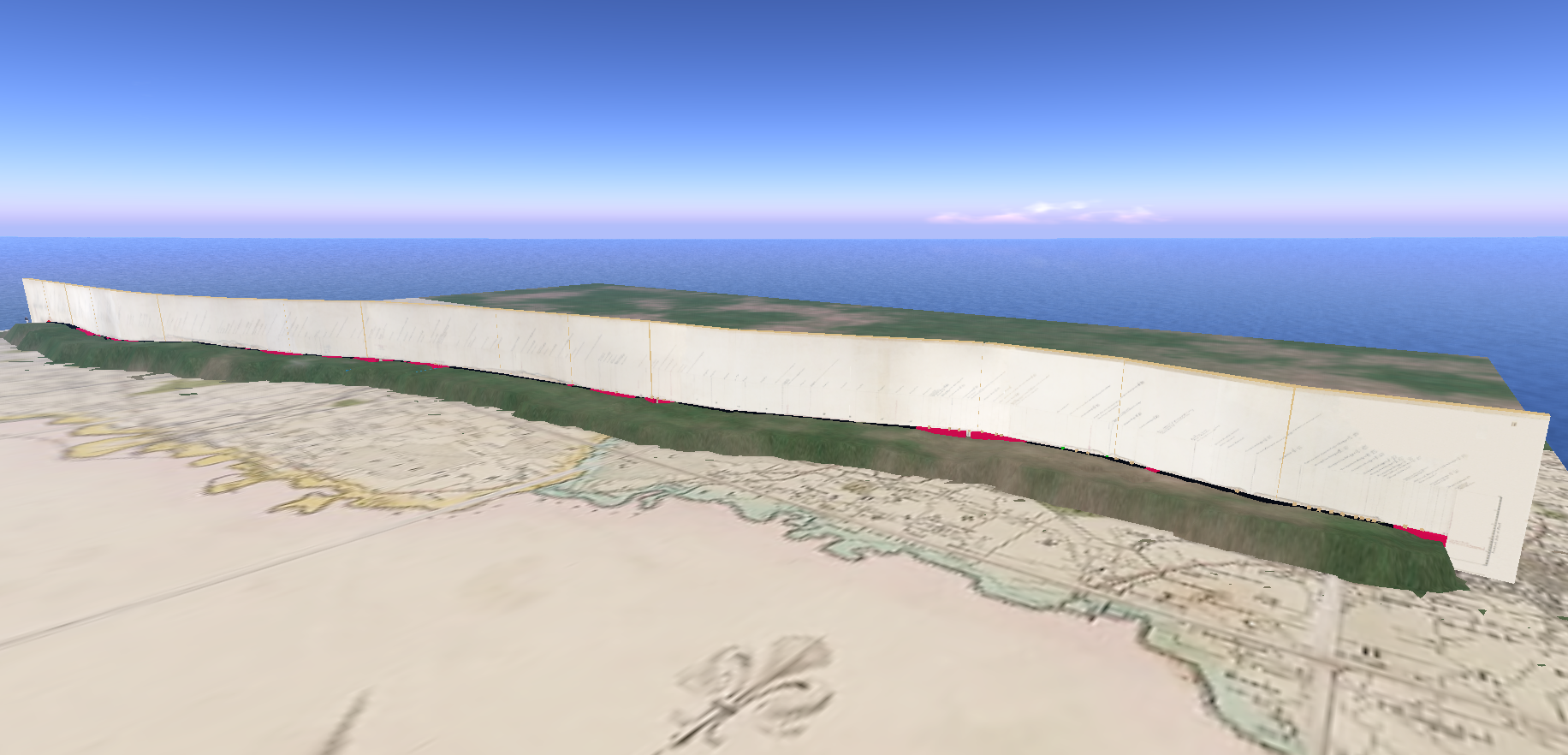
Fig: General view of the OpenSim display which spans the breadth of a single region. The track is displayed at the foot of the vertical panels, either in black or, for embankments and bridges, in red.

The origin of the section

According to Thomas (1980), Telford's assistant, James Mills, found that the only section available in Liverpool during his inspection in December 1828 was the one drawn up by CB Vignoles for the Rennies in 1825 following Stephenson's dismissal. Mills therefore employed a draughtsman to make the copy now with ICE.

There is an immense amount of data in the section but I have no specialist technical knowledge so, as usual, some conjecture…

The Wapping tunnel

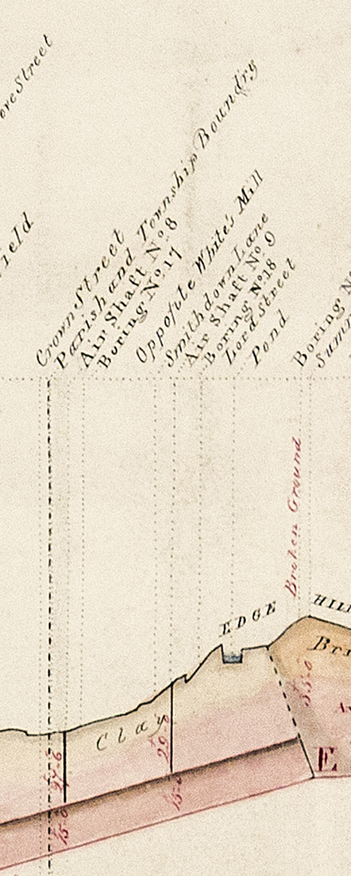
The section starts in Liverpool with the ascent of the Wapping tunnel from the goods station near the docks to Edge Hill. The small tunnel to the passenger terminus at Crown Street is not included (carriage of passengers was a secondary consideration) but there are some potentially interesting sidelights on the tunnel construction at that location.

Firstly, there is an air shaft in close proximity to the extant vent so there is support for the commonly supposed notion that a pre-existing shaft formed the basis for the vent.

telford2
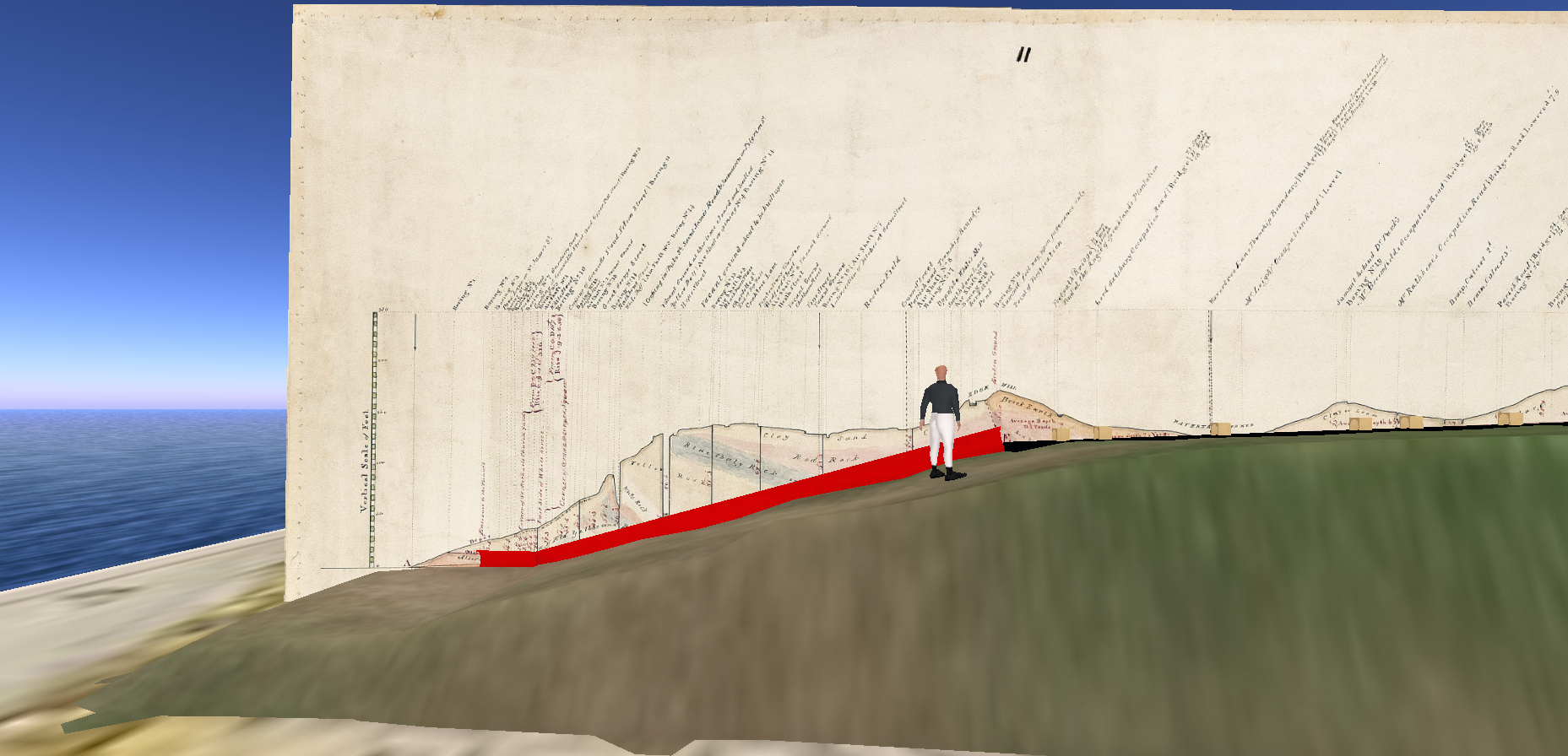
Fig: The ascent of the Wapping tunnel (shown in red). Annotations on the panel above can be seen by manipulating the avatar camera.

However, there is also a "boring" roughly in the middle of the Crown Street field that may have been reused as part of the eye for construction of the tunnel as proposed previously. Note that the majority of borings were presumably carried out for geological purposes prior to construction. The assumption that some were subsequently reused seems reasonable but does not automatically follow. Indeed, the presence of nine air shafts covering the length of the tunnel is in much better agreement with the eight eyes originally put out to contract. The two shafts at Millfield are both specified at 20 feet although the section shows the air vent as 27.5 ft (the adjacent boring is similar) while at Edge Hill ("top of the tunnel") the depth of the boring is in closer agreement (35 ft vs 36 ft in the specification). The section lacks an air shaft at this site, the nearest being east of Smithdown Lane at the top of the current headshunt. Of course, extending the tunnel eastwards would lead into the Chatsworth Street cutting although much of the work there was completed relatively late.

The specification mentions one eye on "vacant ground east of Bedford Street" which presumably equates to an air shaft on the section, both at a depth of about 60 ft. The female penitentiary is also indicated and this is often cited as the location of a drift.

Blackburne Place, the site of a surviving ventilation shaft, is absent from the original specification but the location of both a boring and an air shaft.

In some cases borings and air shafts were in close proximity such as at the White Delf. The section confirms that these were at the level of the bottom of the quarry rather than the adjacent street. In this instance the proximity of the two shafts may have been a response to the limited space available either in a busy quarry or adjacent streets. Alternatively it may have signalled that the site was dual purpose.

Indeed, it is possible that the air shafts are highlighted on the section because they were intended to persist after the remaining sites had been closed up. Although the passage of trains might have been transient, staff would have had to undertake maintenance work on the track and haulage system. We also know from an account by the composer Felix Mendelssohn that staff had fires lit within the tunnel and that the tunnel was lit by gas, both observations supporting the ongoing presence of air shafts. [UPDATED 03/11/2019]

The red route

The section appears to map out two routes through Rainhill, the original (red) mapped by Vignoles and approved in the 1826 Act and an alternative subsequently adopted by the re-appointed Stephenson (black) with support from the Board of Directors but against the advice of the L&MR consulting engineer Josias Jessop.

The red route delivered a more level (and hence operationally cost-effective) railway but required a substantial cutting at Rainhill. The black route on the other hand follows the extant route which was originally to have required stationary engines at the Whiston and Sutton inclined planes which flanked the Rainhill Level. However, the subsequent Rainhill Trials suggested that travelling locomotives would suffice, if necessary either by splitting trains at the inclines or through assistance from a banking engine, i.e. locomotive.

Thomas (1980) suggests that Stephenson's adoption of the inclined planes may have been a strategem to prevent the use of horses for passenger services as specified by the Rennies. Stephenson, of course, had a vested interest in the use of locomotives as well as a profound belief in their being the best option for the future.

telford3
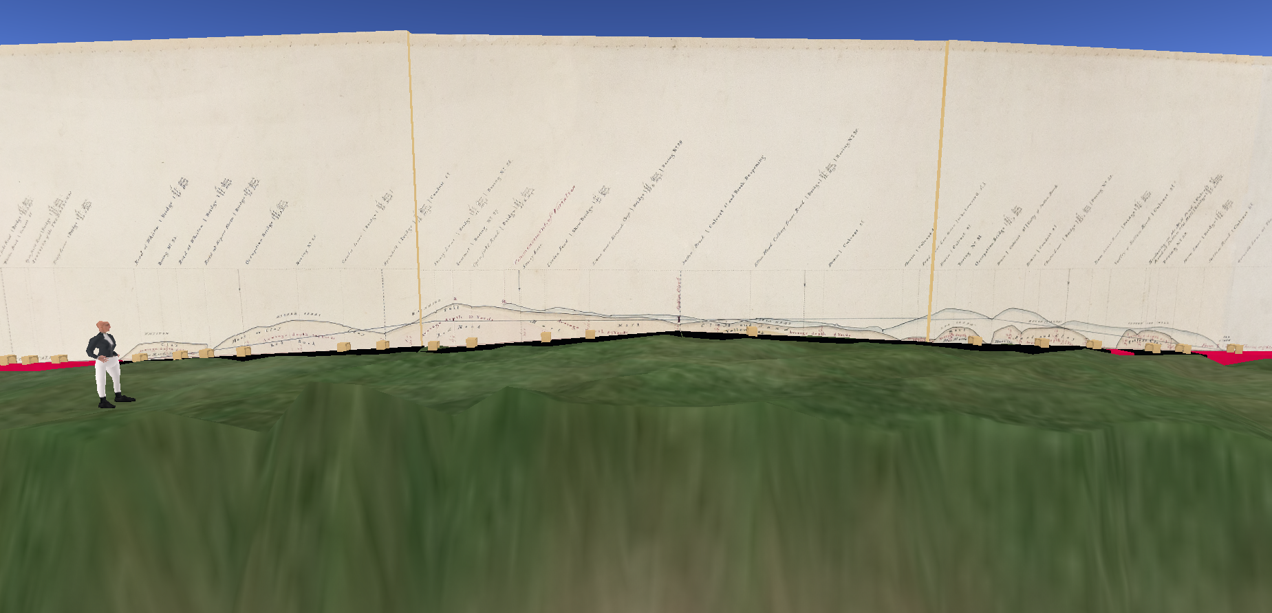
Fig: The track on the display follows the red route favoured by the Rennies. However, the costs of the construction of the huge cutting were such that the black route was adopted as can be seen on the display rising, reaching a level and subsequently falling again.

For the purposes of the display I have used the red route as it is historically interesting and leaves the black route visible above.

Bridges

There are some 91 bridges on the section, both over and under the railway, which are currently represented in the display by bridge icons on the track. Bridges were a significant cost element so it is possible that not all were built if alternative arrangements could be made. On the other hand footbridges were largely omitted from Booth's published list of 63 bridges. One footbridge that features early in the section is visible in the Bury prints of the Moorish Arch.

telford4
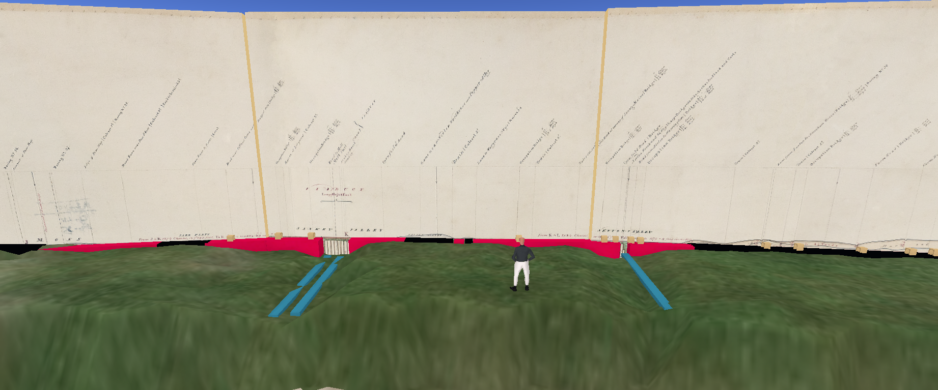
Fig: The embankments are shown in red leading to and from the viaducts as shown on the section for the Sankey valley (only 8 arches!) and at Newton. Note that bridges on the embankments will almost certainly be under-bridges.

Conclusion

The Telford section is a very valuable resource although some care needs to be taken in its interpretation as it represents an intermediate phase in development of the L&MR.

telford5
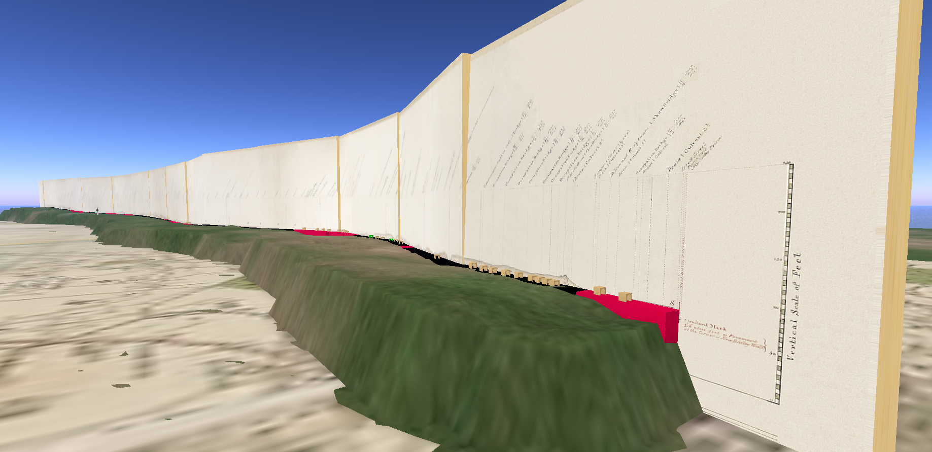
Fig: The section finishes at Salford. Passage across the Irwell and Water Street was a relatively late development.

The OpenSim display was put together in a few hours (terraforming was done manually and thus the principal time sink). The low resolution of the OpenSim terrain was a limiting factor but might be mitigated by building on a larger scale. The ability to program terrain height dynamically makes it feasible to consider simulation of the construction of the railway over time, at least at a gross level.

Acknowledgements

Many thanks to ICE and Paul of the L&MR Trust for access to the section.

The eye at White delf and the Wapping tunnel

When Thomas Talbot Bury visited in Liverpool in 1831, he sketched not only the new railway for his famous Ackermann prints but also St James's cemetery (in the old usage) for ladies journal La Belle Assemblée. The better known of the two cemetery prints shows a man pointing at the tomb of Mr Huskisson, the Liverpool MP who died on the opening day of the Liverpool & Manchester Railway in September the previous year. A public subscription was raised to provide a mausoleum and statue but this came into effect only in 1834 for the mausoleum and 1836 for the statue. An additional melancholy feature not mentioned by the journal is that the cemetery, if not the grave, would have been visible to George Stephenson from his house on Upper Parliament Street.

Liverpool St James bury 2.png
Fig: St James's cemetery in 1831 by Thomas Talbot Bury. Hope Street above left with inclined planes and catacombs. Stephenson's house on Upper Parliament Street is third from left in distance. The lodge on far right is part of Foster's design and extant. The man in the centre is pointing at Huskisson's grave.

The cemetery, along with the earlier non-denominational Necropolis, was a significant innovation and mentioned in contemporary guidebooks to the city. Legend has it that Mrs Huskisson visited it prior to the opening of the railway. It would become invaluable with the cholera pandemics that would commence from 1832.

Liverpool St James bury 1r.png
Fig: Same artist, this time looking towards Hope Street with unfinished Gambier Terrace (possibly by Foster) and, beyond, St Bride's (by Rowlands). Part of the Oratory (mortuary chapel) by Foster to right.

The Mount Quarry and gardens

The cemetery was created to a design by Corporation Surveyor John Foster Jnr when the quarry became exhausted of stone in 1825. However, the quarry situated on a roughly north-south ridge above Liverpool had been active since Norman times and is believed to have been the source of stone for Liverpool castle. In Stuart times there were prosecutions for unauthorised removal of stone. In late Georgian times streets to the east would have been laid out but largely unbuilt with the ridge itself flanked by windmills on either side. In 1767 mayor Thomas Johnson established a public garden and walk at the top of what became known as Mount Sion as a means of generating employment during a harsh winter. With wonderful views of Wales and Cheshire, it became a popular spot for recreation and a bowling green and tavern/coffee shop were established nearby.

liverpool st james mount litho.png
Fig: The Mount by Troughton in Corry's The History of Liverpool, 1810. Nightime scene but probably looking north towards Duke Street across the ridge with the original quarry on the right. The gardens were closed on Sundays which suggests that they were fenced as seen here. Maps (see below) suggest the possible presence of a large house, again as seen here to the right.

The site only became known as St James's Quarry when the church of that name opened off Parliament Street in 1775 (the church also had its own graveyard). In 1800 permission was given for the quarry to be connected to the docks by a "railed road" with wagons taking stone down Parliament Street for use or onward distribution. Unfortunately little is known of its operation and much stone destined for the city was also carted down Duke Street on the opposite side of the ridge.

The British Geological Survey has published a useful analysis of building stone in Liverpool. The stone from the quarry is known as Toxteth Park sandstone. While yellow and soft when first cut, it hardens subsequently and the strong yellow colour diminishes on working. It was used for construction of many of Liverpool's docks, churches and other prominent public buildings such as the Exchange. Curiously it was not used for buildings now on the site such as the Oratory, the mortuary chapel. This as well as the nearby Custom House were made of Storeton stone from the Wirral. Movement of stone from the quarries there took as long as three weeks just to reach the coastal jetty with significant cost in terms of damage to roads. Eventually, as at Liverpool and Helsby, a tramway was established, now long gone.

The small quarries

When the quarry east of the mount was about to run out of stone, two smaller quarries were established to the west off Rathbone Street. Two letters in proceedings of the Liverpool Geological Society provide some useful context. The quarries were operated from Rathbone Street by John Tomkinson Snr and a Mr L(e)atham. Excavation took place from Rathbone Street and reached a maximum depth of 50 feet under the Mount. Notable product included stone for Great George Street Congregational Chapel (the Blackie). The pillars at the front of the church were placed on trolleys in the quarry and lowered by rope down the street under gravity.

liverpool st james cemetery map with 2nd quarry.png
Fig: Undated map, probably c1825, showing the small stone quarry now on opposite side of mount (the adjacent parcel on Washington Street may have been the site of the second quarry). The original quarry was in the blank area below the ropery on Hope Street. The windmills originally on either side of the ridge are no longer evident. Duke Street is just off the map on the left.

It is conceivable that Crown Street station (probably built 1828-9) also used stone from this quarry. The Moorish Arch looks a similar colour in Bury's print but was actually brick and stucco, stone being in short supply when construction commenced in 1829 (it was still unfinished at the opening).

The White Delf eye

Update 24/04/19: Paul from the L&MR Trust has digitised Telford's section which includes details of the Wapping tunnel. It supports the view that the eye and an accompanying air shaft were in the base of the quarry and not at the level of Duke Street.

The 1826 tender document for the Wapping tunnel (which carried freight down to the docks) mentions the White Delf and I suspect this is the northernmost of the two small quarries. It seems unlikely that the old and new quarries were connected as the letters make it clear that the new quarries were served by Rathbone Street and worked progressively from there. However, the old quarry has three tunnels and my guess is that one may have played a subsidiary role in excavation of the Wapping tunnel. Tunnel numbering is consistent with that used on the St James's Cemetery website.

liverpool st james opensim 1.jpg
Fig: Rough OpenSim model of small quarry with eye in quarry and horse gin on land parcel on Duke Street. Grey track leads to tunnel 3 (red) under St James's Row and perhaps then into tunnel 3 under the mount. The position of the Oratory is marked by the windmill although this would likely have been demolished by this stage. Although the quarry is shown fully excavated, it continued to operate for some years subsequently (it is absent from Gage's 1836 map) so this is unlikely. The present-day cathedral is off to the right.

liverpool st james cemetery tunnel herdman.png.jpg
Fig: Herdman sketch looking from tunnel 3 into the original quarry. Looking up, Hope Street would be above the rock face in the distance, a windmill to the left (site now occupied by the Oratory) and to the right pleasure gardens (site now largely occupied by the cathedral).

Tunnel 3: The exit to Duke Street

This may be the oldest tunnel and is the setting for the Herdman sketch above. The present site of the Oratory on the left above the quarry was occupied by a windmill as shown in a lithograph from 1821 by S & G Nicholson. Tunnel 3 ran throught to Duke Street and provided reasonably level access to the quarry for carts and workers and also separated quarry traffic from those coming to enjoy the view and gardens on the Mount. Later, as the website suggests, the tunnel may have been used for funeral processions, perhaps where a horse-drawn hearse would be unable to negotiate the narrower tunnel 1 that visitors continue to use to the present day.

Liverpool St James tunnel 3.jpg
Fig: Tunnel 2 (left) heading on the skew under the mount and tunnel 3 (right, behind tree) heading to Duke Street. Note that the ground level now is much higher than in 1830.

However, the tunnel may have had another use in the meantime, namely to remove spoil from the eye at White Delf. The land parcels on Duke Street appear to have been preserved on the edge of the new quarry and the vacant central parcel may have been the exit point for tunnel 3 from the original quarry.

The eye was in the quarry and 30 feet above the intended tunnel roof. However, one possibility is that some of the material excavated from the tunnel was removed from the site on a light railway that ran through tunnel 3 and into the large quarry where it was used for construction of the catacombs or landscaping of the new cemetery. Accordingly, the lifting machinery (probably a horse gin) may also have been located on the Duke Street parcel.

Under the conditions of the tender the Liverpool & Manchester Railway (L&MR) company was required to provide both the lifting machinery and railed access for the removal of stone and spoil. We know that stone from the tunnel was of inferior quality as contracts had to be renegotiated on the basis of diminished value (tunnel contractors had the rights to the stone). Of course, for other uses the stone and spoil could simply have been carted via Rathbone Street or, if the parcel was used, Duke Street. Use of the parcel may also have reduced interference with normal operation of the remainder of the quarry.

Liverpool St James litho oratory duke st detail.jpg
Fig: The Oratory by John Foster Jnr. To the right could these be the two buildings at the top of Duke Street between which Tunnel 3 may have emerged?.

Tunnel 2: Under the mount

Liverpool St James tunnels 1 and 2.jpg
Fig: Tunnel 1 (above) for access on foot to the gardens/former cemetery and tunnel 2 (below), skewed and leading under the mount.

According to the cemetery website (citing the book "The Building of Liverpool Cathedral"), Tunnel 2 was built in the C18 to provide access to the quarry. It is not visible in the Nicholson lithograph although it may be obscured by an outcrop of rock. Its exit point is, however, unknown although it appears to have an upward slope and may have emerged onto a terrace, now landscaped, partway up the mount and facing the Huskisson mausoleum. This seems not especially useful unless perhaps there was a site office or residence there. The precarious walkway in the Herdman sketch may have had a similar destination and, as maps and Troughton's sketch show, there was at least one building on the Mount and later a terrace called Mount View with subsidiary burial plots beyond.

Plans on the cemetery website seem to suggest that the tunnel originally followed a channel in the rock, the later brick-built tunnel being subsequently covered with spoil. During construction of the cemetery and Wapping tunnel it may have provided access to a useful tipping point for spoil brought through Tunnel 2. The possibility of a continuous tramway up to the terrace would explain the pronounced skew towards the exit from Tunnel 2.

The Wapping tunnel was completed in 1828 and the cemetery opened in early 1830 (Huskisson was not the first burial).

The role of John Foster Jnr

Corporation surveyor Foster was the lynchpin of Liverpool's development during this period. He was architect both of the cemetery and the nearby Custom House. Although best known for classical designs such as the Oratory, he was also appointed by the L&MR as engineer with immediate responsibility for the entire Wapping tunnel (the actual work was done by contractors). This was, however, a post he held for only a short time, his resignation coinciding with the arrival of the very young Joseph Locke as his immediate superior. While there is some suggestion that he may have seen this as an insult, it is just as likely that he had too many other projects underway to be able to give sufficient attention to issues concerning the Wapping tunnel.

The present day

If the hypothesis above is correct, the exit from Tunnel 2 onto Duke Street would nowadays be under the LIPA primary school and the eye possibly in its courtyard to the rear. Both tunnels supposedly supporting the light railway are now bricked up.

Aerial photographs from 1949 show how exploiting the small quarry levelled that part of the hillside; by 1836 it was the site of a cooperage but now it is landscaped and occupied by student accommodation. The eye (and quarry) are on the opposite side of Rathbone Street from the ventilation shaft introduced in the late 1890s to permit working of the Wapping tunnel by locomotives. Rathbone Street, named for the family of philanthropic merchants, has itself disappeared.

Liverpool St James aerial photo 1949.jpg
Fig: The flattened area to the bottom left is presumably the floor of the small quarry. The Anglican cathedral can be seen under construction on the right and the Oratory overlooking the cemetery is top right. Rathbone Street runs diagonally across bottom left, Duke Street is on the far side of the quarry. Thanks to Britain from Above for the 1949 image which has been cropped to highlight the pertinent area. Fun fact: the former quarry features in 1950 film The Magnet as the scene of an informal cricket match.

Plausible exit point for tunnel from St James' cemetery as of 1924 annotated.png
Fig: Arrows show plausible exit point for tunnel 3 and associated gate from St James' cemetery as of 1924. The ornaments atop either side of the gate are likely carved lions. Thanks to Britain from Above for the 1924 image which has been cropped to highlight the pertinent area. (Updated: 20/10/18)

The cemetery finally closed to burials in 1936 by which time almost 58000 burials had taken place. It became a public garden c.1962 and present-day visitors to the Anglican cathedral on the mount above may also follow a path via Tunnel 1 through the rock down to the gardens below.

The Eye at Millers Close

Liverpool Crown Street station was the western terminus of the Liverpool & Manchester Railway (L&MR) which opened in 1830, arguably the first modern railway. While looking for parch marks at Crown Street recently, an intriguing depression was noted that raised the possibility that this was the site of the shaft or eye used to construct this section of the Wapping Tunnel. This famous tunnel took wagons down to the Park Lane goods station close to the Mersey docks. The start of the tunnel was in the Cavendish cutting east of Crown Street where the stationary engine in the Moorish Arch was used to pull the wagons back up.

Liverpool Crown St depression (3).jpg
Fig: Crown Street park looking towards the entrance on Crown Street and the adjacent ventilation tower which stands above a shaft down to the Wapping tunnel. The depression is highlighted and a curved parch mark can be seen between the depression and the tower.

The tunnel

There were some eight shafts (or eyes) used to construct the Wapping tunnel and conventional wisdom suggests that the LNWR reused five of these when they built the ventilation towers in the late 1890s so that locomotives could work the tunnel. The ventilation tower at Crown Street was built in 1899 and is one of the few visible reminders of Crown Street's connection with the early railway. On the opening day on 15th September 1830, the trains started at Crown Street but on their return went down the Wapping tunnel.

The tunnel was built by contractors working in either direction from each eye, normally some 200-300 m distant. The call for tenders went out on 23 August 1826 and closed just over a week later on 2nd September. However, purchase of the field at Crown Street was not agreed by the Board until 15 Jan 1827 so there may have been some delay in starting there unless special arrangements were made with the owner of the field and nearby mill, Stephen White. .

Work had, however, started some time before 19th Feb 1827 as at the Board meeting that day the Principal Engineer George Stephenson recommended that the price of most contracts be increased due to the poor quality of the stone extracted (contractors were allowed to sell the stone they quarried and the return was presumably lower than anticipated). Stephenson listed six shafts particularly affected rather than the eight in the tender document:

White Street
White Delf
Yellow Delf
Mosslake Fields (Copelands [the contractor])
Millers Close
Penitentiary Drift

They appear, however, to be in the same numerical order with the former White Street shaft being closest to Park Lane/Wapping. Millers Close presumably refers to the parcel purchased from White.

Penitentiary Drift may refer to an additional shaft required to correct for an error of 13 feet made in surveying by Vignoles or, more specifically, to the person he delegated to do the poling while busy elsewhere. In 1824 the Liverpool Female Penitentiary was located at the corner of Mulberry Street (which extended much further than now) and Crabtree Lane/Falkner Street (27 on map) which is on the general line of the tunnel and presumably close to the site of the supplementary shaft. The source of the error was discussed at some length in a letter from Vignoles to his sponsor Riddle. Stephenson made a considerable fuss and, disregarded, Vignoles reluctantly resigned on 2nd February 1827 although he subsequently went on to a distinguished career in civil engineering.

The eye at Crown Street

The tender document specifies that the shaft should be "at the centre of the lot they contract for" and, although unstated, close to the line of the tunnel. Even allowing for a less well defined boundary, the Crown Street ventilation tower is decidedly off-centre while the candidate eye is in the expected location. Of course, the definition of a specific "lot" might have a bearing, in this case it simply being "field E(ast) of Crown Street".

If Gage's 1836 map is accurate, then the Wapping tunnel runs roughly parallel to the station with its western edge coinciding with the wall dividing the passenger station from the adjacent Millfield station as seen in Bury's print. If we assume that the northern face of the eye was 30 feet from this dividing wall and the tunnel below, it would place the eye close to the station platform/verandah.

Two consequences arise. Firstly, the eye may have been contiguous with a basement level in the station building. Perhaps more significantly, it makes it less likely that the station was built at the same time as the tunnel excavation was taking place or, indeed, at the same time as the workshops, stores and stables. The latter were completed by July 1827 when payment of the roofer was agreed by the Finance Committee. This may in turn make it less likely that Stephenson and Gooch designed the station as part of the first tranche of buildings (there is no specific mention of it) although the general position of the station was necessarily determined at an early stage.

The LNWR plans for the Crown Street ventilation shaft and tower make no obvious mention of a preexisting shaft but do provide interesting data. The depth of the shaft above the tunnel is of the order of 18 feet which, when added to the height of the tunnel (16 feet), gives a total of 34 feet compared to the 30 feet mentioned in the tender document. This difference may be accounted for in part by the distance between the two and the gradient of the tunnel (1 in 48); there may also have been some exploratory work in advance of the tender. In any event it does suggest that the ground had been levelled by this stage instead of sloping up to Smithdown Lane and adding to the depth of shaft required. The tender document refers to the use of wagons and rails to move the stone, clay and spoil away from the eye which also suggests that the ground would need to be reasonably level.

The eye itself was only 6 feet x 10 feet in cross-section. The depression in the ground at Crown Street has an oval shape elongated towards the tunnel suggesting that the passage to the tunnel, some 20 feet away, was only 6 feet wide although Engineering Timelines suggests a passage nearer 8 feet square. Even so, it is possible that there might have been "rooms" off this passage way, most notably stables for the ponies responsible for hauling wagons on the temporary narrow gauge railroad extending into the tunnel. According to Thomas (1980), these animals only emerged into daylight once passage to the surface via the tunnel was possible. Proximity to the air intake might have made their situation marginally easier to bear.

Although stone and clay had some value, general spoil was carted either for immediate use to fill holes or make embankments or for temporary storage prior to such use. R Gladstone in the Board minutes of 8 Oct 1827 suggested that stone etc from the Millfield shaft be transported by a temporary railroad in front of the Botanic Garden to the low ground between the front of the Botanic Garden and Abercromby Square.

Telford's cross-section (Update 23/04/2019)

Paul from the L&MR Trust recently posted a cross-section from Telford's survey of the tunnel as it passed under Liverpool. Although subject to interpretation, it appears to suggest that there were TWO shafts at Crown Street, an air shaft roughly in the position of the existing vent and which may have been reused in its construction and a shaft termed "boring #17" which presumably represents the location of the eye. The latter appears to be roughly 48 m east of the then Liverpool boundary which is roughly the position of the depression/candidate eye discussed above. The section suggests that the top of the tunnel was 27.5 ft below the surface although it erroneously states the tunnel was 15 ft high (16 ft is more commonly accepted).

liverpool manchester section telford crown st
Fig: The relevant part of Telford's section courtesy of ICE and Liverpool & Manchester Railway Trust.

The Close

liverpool crown street eye with vent2.png
Fig: Schematic model built in OpenSim looking through the Crown Street gates towards Smithdown Lane at the top of the escarpment. Part of the surface has been made semi-transparent so that the eye and connecting passage can be seen. The tunnel can be seen at the bottom right. The tower is shown in grey and would not have been present at this time.

In the schematic I have interpreted the Close as being a cul-de-sac. Although the majority of notable parch marks oriented with known sidings, there was one curved mark that is not readily explained from known configurations of track and paths. While there may have been additional unknown features, it is also possible that it marks the location of the pathway into the close or alternatively was used during construction of the nearby tower.

Liverpool Crown St station opensim model with eye highlighted.png

Fig: The approximate position of the shaft highlighted on the OpenSim model

Conclusions

The tunnels from the Millers Close/Millfield and Mosslake Fields eyes met on 26 November 1827 and completion of the tunnel as a whole was reported to the board on 9 June 1828. At that stage the eye would have been superfluous and presumably backfilled and bricked up. It would be interesting to know whether there is any trace in the tunnel itself.

A case can be made for the depression seen in today's Crown Street park being the site of the original eye, albeit with its connection to the tunnel bricked up once it was no longer needed. Engineering Timelines suggests that the eyes were positioned south of the tunnel rather than north as here. However, a northerly location at Crown Street would afford a slightly shorter distance to the gates for removal of spoil.

The question then arises as to why the LNWR chose to ignore the eye rather than having it form the basis of the shaft for the ventilation tower. The answer here may be unique to Crown Street which by the end of the century had become a busy depot for coal and agricultural goods. Putting a tower in the centre of the plot would simply be too disruptive in terms of blocking track from the tunnels going to more distant parts of the site. The situation would be different at the other sites.

An alternative possibility alluded to by Thomas (1980) is that the depression was the result of a widely reported collpase of the tunnel due to use of too few props. However, it seems odd that it should have survived landscaping of the station and subsequently the park as well as being some distance from the tunnel itself.

If the depression could be proven to be the eye, it would form the sole surface feature presently visible in Crown Street that derives from the 1830 railway, albeit only from its construction phase. Even so it would be a testament to the courage of the men who built the first railway tunnel to pass under a major town and which played a significant role in the industrial revolution in the north-west of England. It also forms a valuable marker for the station itself.

Thanks to the Liverpool & Manchester Railway Trust for making available the tunnel tender document and tower plans

Last updated 23/04/19